Opal Lake Topo Map Idaho
To zoom in, hover over the map of Opal Lake
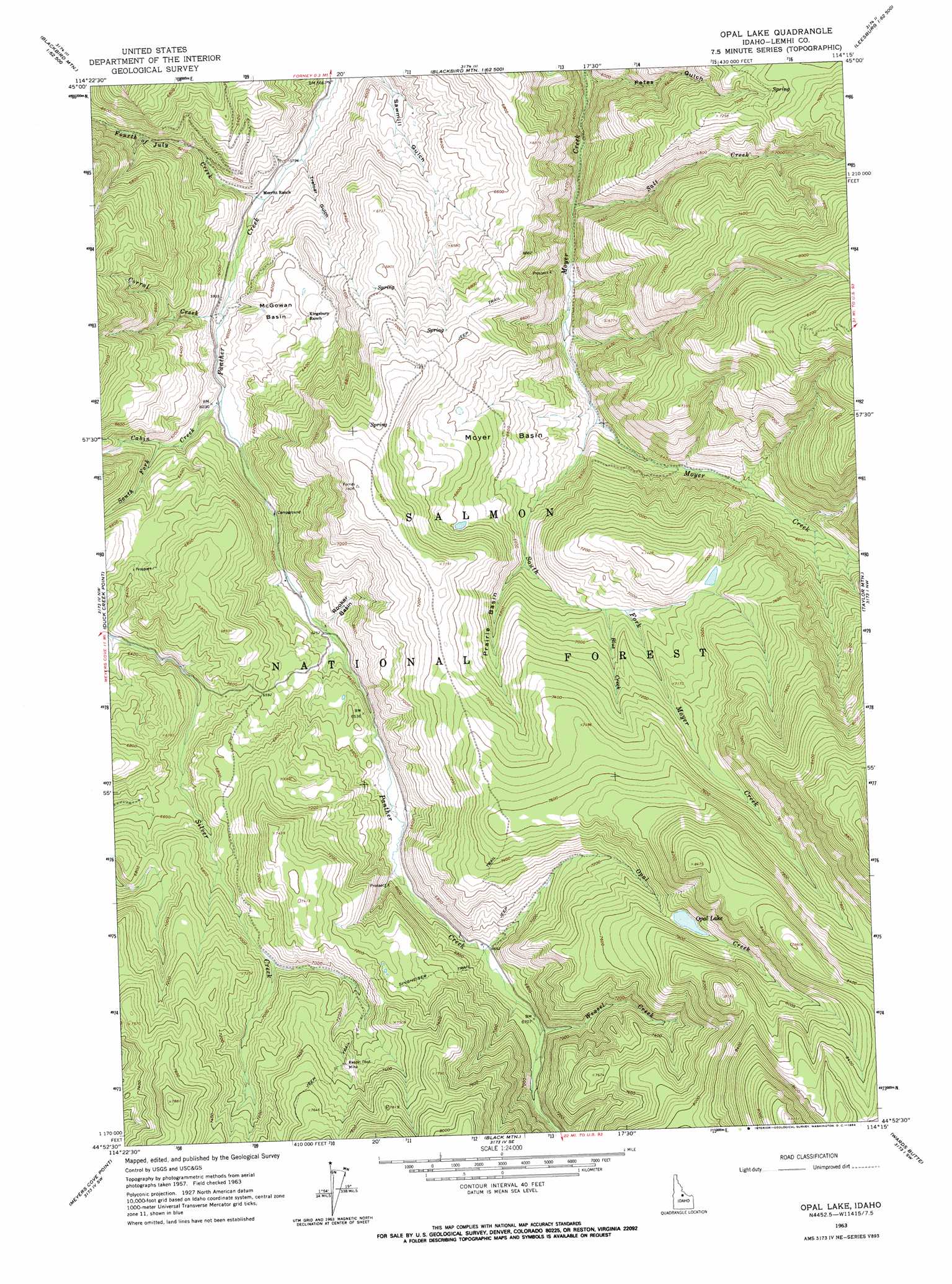
USGS Topo Quad 44114h3 - 1:24,000 scale
| Topo Map Name: | Opal Lake |
| USGS Topo Quad ID: | 44114h3 |
| Print Size: | ca. 21 1/4" wide x 27" high |
| Southeast Coordinates: | 44.875° N latitude / 114.25° W longitude |
| Map Center Coordinates: | 44.9375° N latitude / 114.3125° W longitude |
| U.S. State: | ID |
| Filename: | o44114h3.jpg |
| Download Map JPG Image: | Opal Lake topo map 1:24,000 scale |
| Map Type: | Topographic |
| Topo Series: | 7.5´ |
| Map Scale: | 1:24,000 |
| Source of Map Images: | United States Geological Survey (USGS) |
| Alternate Map Versions: |
Opal Lake ID 1963, updated 1964 Download PDF Buy paper map Opal Lake ID 1963, updated 1964 Download PDF Buy paper map Opal Lake ID 2011 Download PDF Buy paper map Opal Lake ID 2013 Download PDF Buy paper map |
| FStopo: | US Forest Service topo Opal Lake is available: Download FStopo PDF Download FStopo TIF |
1:24,000 Topo Quads surrounding Opal Lake
Mount Mcguire |
Gant Ridge |
Gant Mountain |
Jureano Mountain |
Leesburg |
Hoodoo Meadows |
Blackbird Mountain |
Blackbird Creek |
Cobalt |
Lake Mountain |
Yellowjacket |
Duck Creek Point |
Opal Lake |
Taylor Mountain |
Degan Mountain |
Meyers Cove |
Meyers Cove Point |
Black Mountain |
Wards Butte |
Hat Creek |
Sheldon Peak |
White Goat Mountain |
Blowfly Creek |
Gooseberry Creek |
Ellis |
> Back to 44114e1 at 1:100,000 scale
> Back to 44114a1 at 1:250,000 scale
> Back to U.S. Topo Maps home
Opal Lake topo map: Gazetteer
Opal Lake: Basins
McGowan Basin elevation 1861m 6105′Moyer Basin elevation 2023m 6637′
Rooker Basin elevation 1956m 6417′
Opal Lake: Lakes
Opal Lake elevation 2300m 7545′Opal Lake: Mines
Rabbit Foot Mine elevation 2245m 7365′Opal Lake: Populated Places
Forney elevation 1725m 5659′Opal Lake: Streams
Blue Creek elevation 2076m 6811′Cabin Creek elevation 1833m 6013′
Corral Creek elevation 1805m 5921′
Fourth of July Creek elevation 1761m 5777′
Opal Creek elevation 2026m 6646′
Salt Creek elevation 1790m 5872′
South Fork Cabin Creek elevation 1875m 6151′
South Fork Moyer Creek elevation 1865m 6118′
Weasel Creek elevation 2047m 6715′
Opal Lake: Trails
Singheiser Trail elevation 2150m 7053′Opal Lake: Valleys
Petes Gulch elevation 1802m 5912′Prairie Basin elevation 1985m 6512′
Treloar Gulch elevation 1760m 5774′
Opal Lake digital topo map on disk
Buy this Opal Lake topo map showing relief, roads, GPS coordinates and other geographical features, as a high-resolution digital map file on DVD: