Edaho Mountain Topo Map Idaho
To zoom in, hover over the map of Edaho Mountain
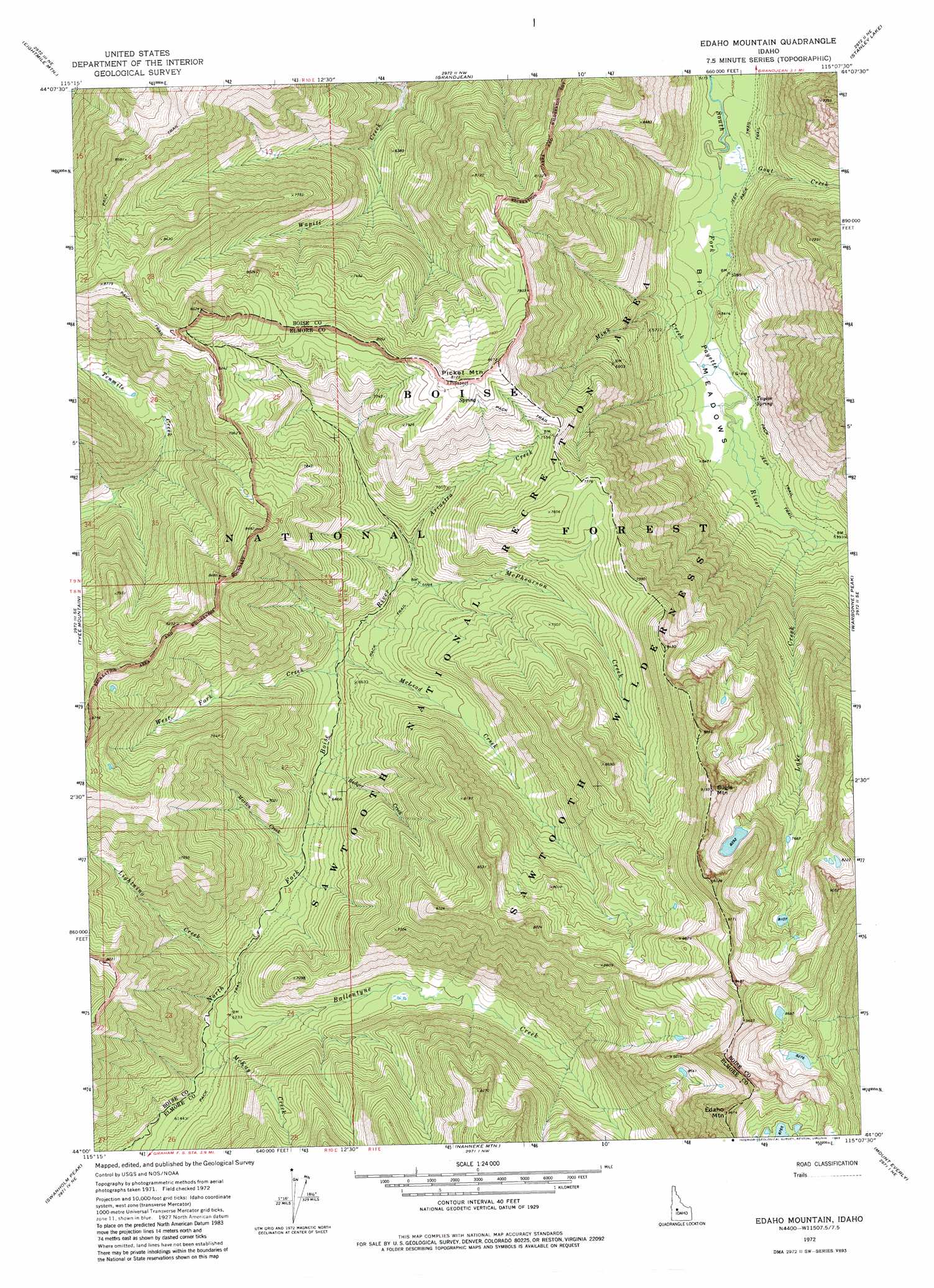
USGS Topo Quad 44115a2 - 1:24,000 scale
| Topo Map Name: | Edaho Mountain |
| USGS Topo Quad ID: | 44115a2 |
| Print Size: | ca. 21 1/4" wide x 27" high |
| Southeast Coordinates: | 44° N latitude / 115.125° W longitude |
| Map Center Coordinates: | 44.0625° N latitude / 115.1875° W longitude |
| U.S. State: | ID |
| Filename: | o44115a2.jpg |
| Download Map JPG Image: | Edaho Mountain topo map 1:24,000 scale |
| Map Type: | Topographic |
| Topo Series: | 7.5´ |
| Map Scale: | 1:24,000 |
| Source of Map Images: | United States Geological Survey (USGS) |
| Alternate Map Versions: |
Edaho Mountain ID 1972, updated 1976 Download PDF Buy paper map Edaho Mountain ID 1972, updated 1983 Download PDF Buy paper map Edaho Mountain ID 2011 Download PDF Buy paper map Edaho Mountain ID 2013 Download PDF Buy paper map |
| FStopo: | US Forest Service topo Edaho Mountain is available: Download FStopo PDF Download FStopo TIF |
1:24,000 Topo Quads surrounding Edaho Mountain
Cache Creek |
Bull Trout Point |
Banner Summit |
Elk Meadow |
Basin Butte |
Miller Mountain East |
Eightmile Mountain |
Grandjean |
Stanley Lake |
Stanley |
Jackson Peak |
Tyee Mountain |
Edaho Mountain |
Warbonnet Peak |
Mount Cramer |
Bear River |
Swanholm Peak |
Nahneke Mountain |
Mount Everly |
Snowyside Peak |
Grand Mountain |
Phifer Creek |
Atlanta West |
Atlanta East |
Marshall Peak |
> Back to 44115a1 at 1:100,000 scale
> Back to 44114a1 at 1:250,000 scale
> Back to U.S. Topo Maps home
Edaho Mountain topo map: Gazetteer
Edaho Mountain: Flats
Big Meadows elevation 1617m 5305′Edaho Mountain: Springs
Taylor Spring elevation 1622m 5321′Edaho Mountain: Streams
Arrastra Creek elevation 2055m 6742′Badger Creek elevation 1944m 6377′
Ballentyne Creek elevation 1854m 6082′
Goat Creek elevation 1595m 5232′
Lake Creek elevation 1633m 5357′
Lightning Creek elevation 1889m 6197′
Marten Creek elevation 1922m 6305′
McKay Creek elevation 1853m 6079′
McLeod Creek elevation 1981m 6499′
McPhearson Creek elevation 2190m 7185′
Mink Creek elevation 1604m 5262′
West Fork Creek elevation 1972m 6469′
Edaho Mountain: Summits
Bugle Mountain elevation 2796m 9173′Edaho Mountain elevation 2921m 9583′
Picket Mountain elevation 2478m 8129′
Edaho Mountain digital topo map on disk
Buy this Edaho Mountain topo map showing relief, roads, GPS coordinates and other geographical features, as a high-resolution digital map file on DVD: