Jackson Peak Topo Map Idaho
To zoom in, hover over the map of Jackson Peak
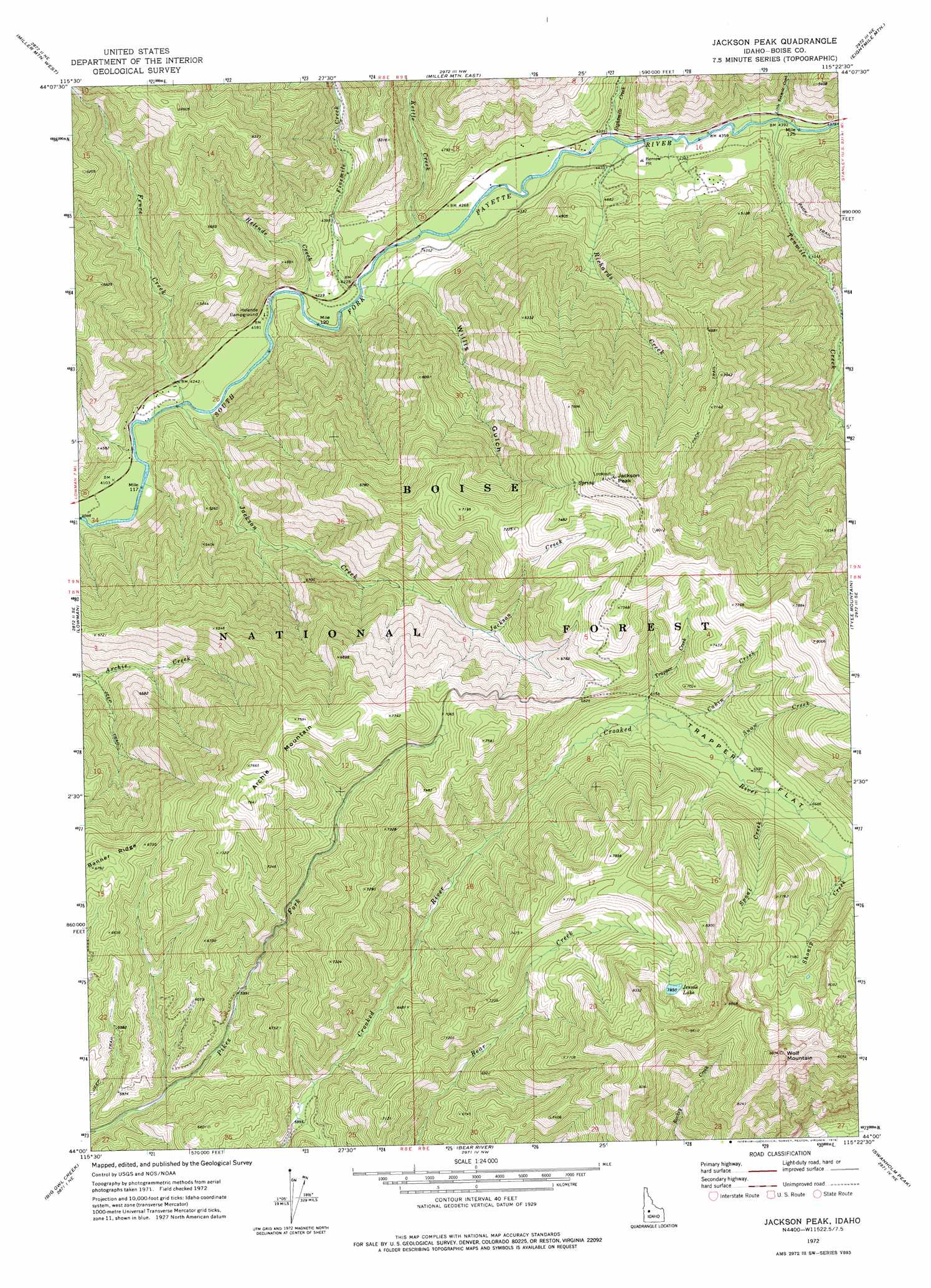
USGS Topo Quad 44115a4 - 1:24,000 scale
| Topo Map Name: | Jackson Peak |
| USGS Topo Quad ID: | 44115a4 |
| Print Size: | ca. 21 1/4" wide x 27" high |
| Southeast Coordinates: | 44° N latitude / 115.375° W longitude |
| Map Center Coordinates: | 44.0625° N latitude / 115.4375° W longitude |
| U.S. State: | ID |
| Filename: | o44115a4.jpg |
| Download Map JPG Image: | Jackson Peak topo map 1:24,000 scale |
| Map Type: | Topographic |
| Topo Series: | 7.5´ |
| Map Scale: | 1:24,000 |
| Source of Map Images: | United States Geological Survey (USGS) |
| Alternate Map Versions: |
Jackson Peak ID 1972, updated 1976 Download PDF Buy paper map Jackson Peak ID 2011 Download PDF Buy paper map Jackson Peak ID 2013 Download PDF Buy paper map |
| FStopo: | US Forest Service topo Jackson Peak is available: Download FStopo PDF Download FStopo TIF |
1:24,000 Topo Quads surrounding Jackson Peak
Deadwood Reservoir |
Whitehawk Mountain |
Cache Creek |
Bull Trout Point |
Banner Summit |
Scott Creek |
Miller Mountain West |
Miller Mountain East |
Eightmile Mountain |
Grandjean |
Pine Flat |
Lowman |
Jackson Peak |
Tyee Mountain |
Edaho Mountain |
Sunset Mountain |
Big Owl Creek |
Bear River |
Swanholm Peak |
Nahneke Mountain |
Rabbit Creek Summit |
Barber Flat |
Grand Mountain |
Phifer Creek |
Atlanta West |
> Back to 44115a1 at 1:100,000 scale
> Back to 44114a1 at 1:250,000 scale
> Back to U.S. Topo Maps home
Jackson Peak topo map: Gazetteer
Jackson Peak: Flats
Trappers Flat elevation 2011m 6597′Jackson Peak: Lakes
Jennie Lake elevation 2400m 7874′Jackson Peak: Streams
Cabin Creek elevation 1973m 6473′Eightmile Creek elevation 1315m 4314′
Fence Creek elevation 1258m 4127′
Fivemile Creek elevation 1289m 4229′
Helende Creek elevation 1273m 4176′
Jackson Creek elevation 1256m 4120′
Kettle Creek elevation 1297m 4255′
Little Tenmile Creek elevation 1330m 4363′
Richards Creek elevation 1317m 4320′
Shonip Creek elevation 2049m 6722′
Snow Creek elevation 2000m 6561′
Spout Creek elevation 2013m 6604′
Tenmile Creek elevation 1330m 4363′
Trappers Creek elevation 1963m 6440′
Jackson Peak: Summits
Archie Mountain elevation 2335m 7660′Jackson Peak elevation 2471m 8106′
Wolf Mountain elevation 2699m 8854′
Jackson Peak: Valleys
Willis Gulch elevation 1286m 4219′Jackson Peak digital topo map on disk
Buy this Jackson Peak topo map showing relief, roads, GPS coordinates and other geographical features, as a high-resolution digital map file on DVD: