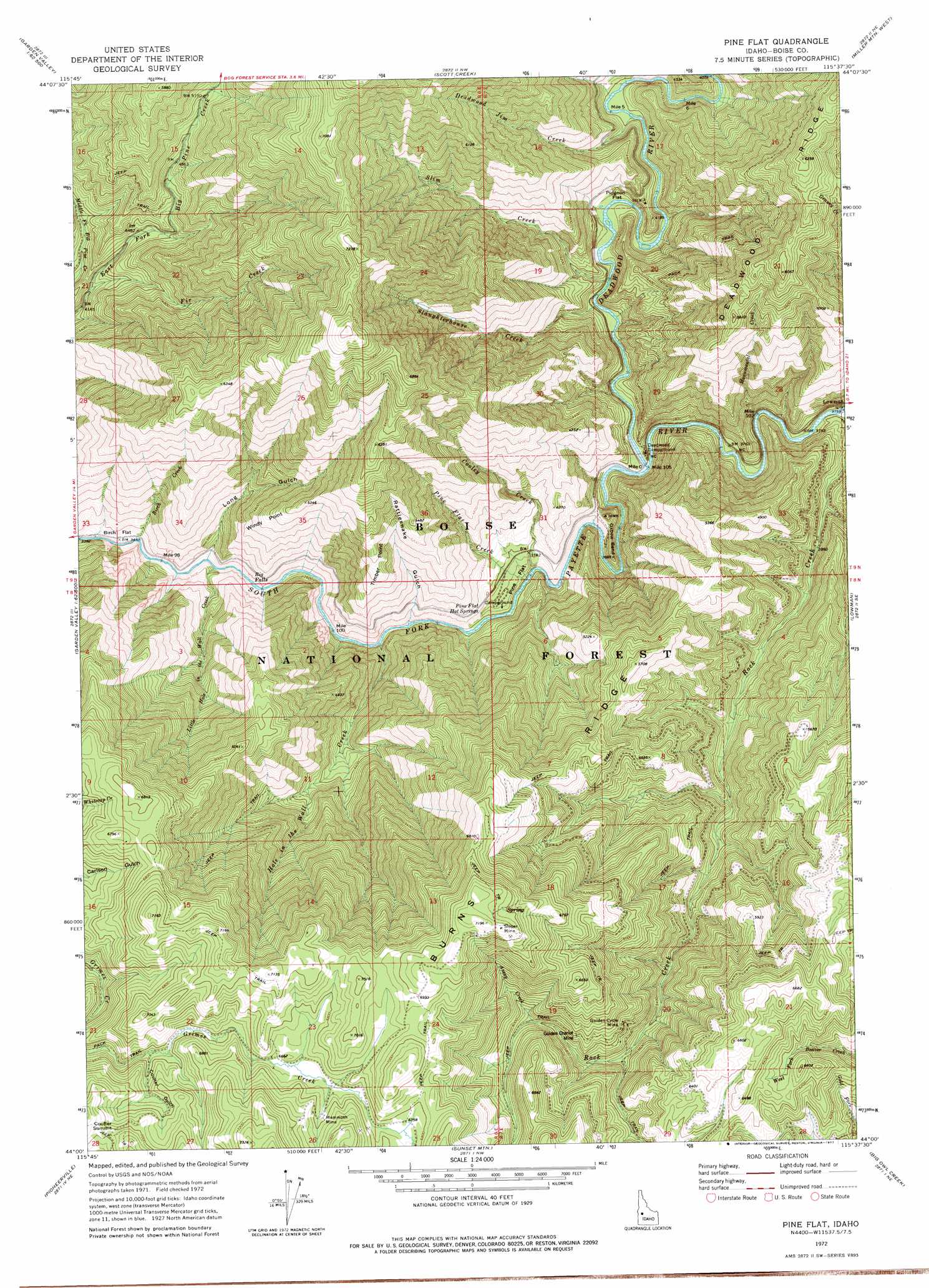
Pine Flat Topo Map Idaho
To zoom in, hover over the map of Pine Flat
USGS Topo Quad 44115a6 - 1:24,000 scale
| Topo Map Name: | Pine Flat |
| USGS Topo Quad ID: | 44115a6 |
| Print Size: | ca. 21 1/4" wide x 27" high |
| Southeast Coordinates: | 44° N latitude / 115.625° W longitude |
| Map Center Coordinates: | 44.0625° N latitude / 115.6875° W longitude |
| U.S. State: | ID |
| Filename: | o44115a6.jpg |
| Download Map JPG Image: | Pine Flat topo map 1:24,000 scale |
| Map Type: | Topographic |
| Topo Series: | 7.5´ |
| Map Scale: | 1:24,000 |
| Source of Map Images: | United States Geological Survey (USGS) |
| Alternate Map Versions: |
Pine Flat ID 1972, updated 1977 Download PDF Buy paper map Pine Flat ID 1972, updated 1977 Download PDF Buy paper map Pine Flat ID 2011 Download PDF Buy paper map Pine Flat ID 2013 Download PDF Buy paper map |
| FStopo: | US Forest Service topo Pine Flat is available: Download FStopo PDF Download FStopo TIF |
1:24,000 Topo Quads surrounding Pine Flat
Sixmile Point |
Boiling Springs |
Deadwood Reservoir |
Whitehawk Mountain |
Cache Creek |
Pyle Creek |
Lightning Ridge |
Scott Creek |
Miller Mountain West |
Miller Mountain East |
Garden Valley |
Grimes Pass |
Pine Flat |
Lowman |
Jackson Peak |
Placerville |
Pioneerville |
Sunset Mountain |
Big Owl Creek |
Bear River |
Warm Springs Point |
Idaho City |
Rabbit Creek Summit |
Barber Flat |
Grand Mountain |
> Back to 44115a1 at 1:100,000 scale
> Back to 44114a1 at 1:250,000 scale
> Back to U.S. Topo Maps home
Pine Flat topo map: Gazetteer
Pine Flat: Bends
Oxbow Bend elevation 1170m 3838′Pine Flat: Capes
Timber Point elevation 1622m 5321′Windy Point elevation 1489m 4885′
Pine Flat: Falls
Big Falls elevation 1062m 3484′Pine Flat: Flats
Birch Flat elevation 1068m 3503′Pidgeon Flat elevation 1189m 3900′
Pine Flat elevation 1126m 3694′
Pine Flat: Mines
Golden Chariot Mine elevation 1796m 5892′Golden Cycle Mine elevation 1789m 5869′
Mammoth Mine elevation 2070m 6791′
Sloper Mine elevation 2178m 7145′
Pine Flat: Ridges
Burns Ridge elevation 2071m 6794′Pine Flat: Springs
Pine Flat Hot Springs elevation 1174m 3851′Pine Flat: Streams
Assay Creek elevation 1781m 5843′Birch Creek elevation 1042m 3418′
Cooley Creek elevation 1097m 3599′
Deadwood Jim Creek elevation 1208m 3963′
Deadwood River elevation 1122m 3681′
Fir Creek elevation 1280m 4199′
Hole in the Wall Creek elevation 1083m 3553′
Little Hole in the Wall Creek elevation 1051m 3448′
Monumental Creek elevation 1141m 3743′
Pine Flat Creek elevation 1106m 3628′
Road Fork Creek elevation 1234m 4048′
Rock Creek elevation 1152m 3779′
Slaughterhouse Creek elevation 1159m 3802′
Slim Creek elevation 1174m 3851′
Stevens Creek elevation 1250m 4101′
Pine Flat: Summits
Coulter Summit elevation 2137m 7011′Pine Flat: Valleys
Coulter Gulch elevation 1998m 6555′Long Gulch elevation 1062m 3484′
Rattlesnake Gulch elevation 1134m 3720′
Pine Flat digital topo map on disk
Buy this Pine Flat topo map showing relief, roads, GPS coordinates and other geographical features, as a high-resolution digital map file on DVD: