Grimes Pass Topo Map Idaho
To zoom in, hover over the map of Grimes Pass
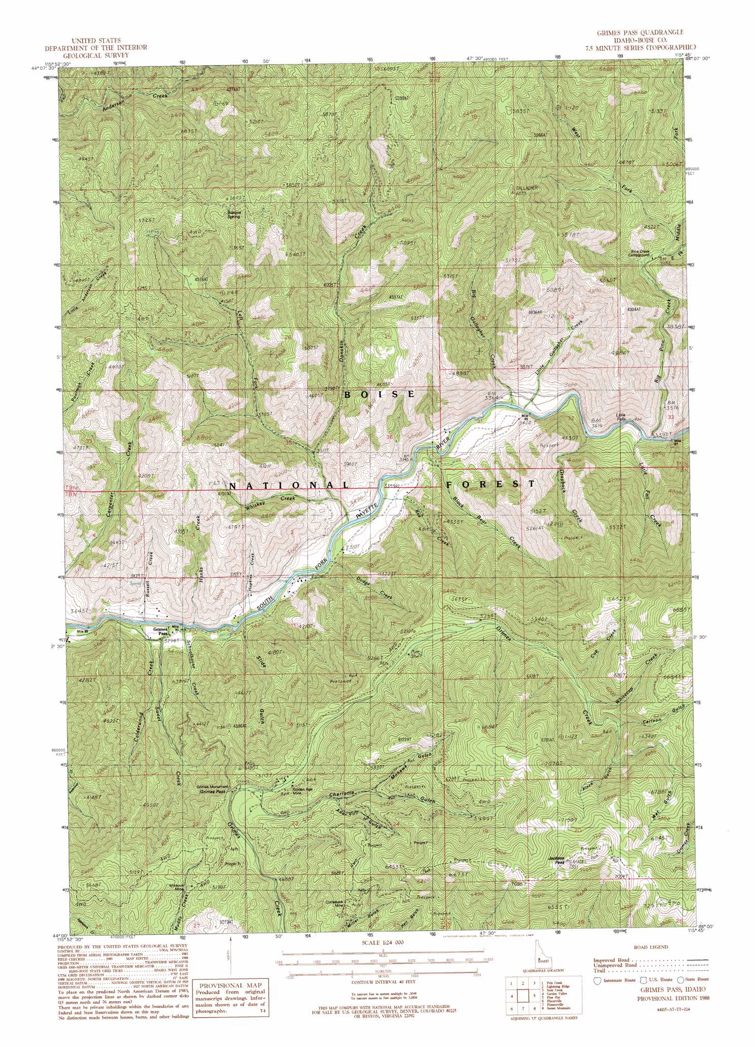
USGS Topo Quad 44115a7 - 1:24,000 scale
| Topo Map Name: | Grimes Pass |
| USGS Topo Quad ID: | 44115a7 |
| Print Size: | ca. 21 1/4" wide x 27" high |
| Southeast Coordinates: | 44° N latitude / 115.75° W longitude |
| Map Center Coordinates: | 44.0625° N latitude / 115.8125° W longitude |
| U.S. State: | ID |
| Filename: | o44115a7.jpg |
| Download Map JPG Image: | Grimes Pass topo map 1:24,000 scale |
| Map Type: | Topographic |
| Topo Series: | 7.5´ |
| Map Scale: | 1:24,000 |
| Source of Map Images: | United States Geological Survey (USGS) |
| Alternate Map Versions: |
Grimes Pass ID 1988, updated 1989 Download PDF Buy paper map Grimes Pass ID 2011 Download PDF Buy paper map Grimes Pass ID 2013 Download PDF Buy paper map |
| FStopo: | US Forest Service topo Grimes Pass is available: Download FStopo PDF Download FStopo TIF |
1:24,000 Topo Quads surrounding Grimes Pass
Smiths Ferry |
Sixmile Point |
Boiling Springs |
Deadwood Reservoir |
Whitehawk Mountain |
Packer John Mountain |
Pyle Creek |
Lightning Ridge |
Scott Creek |
Miller Mountain West |
Banks |
Garden Valley |
Grimes Pass |
Pine Flat |
Lowman |
Harris Creek Summit |
Placerville |
Pioneerville |
Sunset Mountain |
Big Owl Creek |
Shafer Butte |
Warm Springs Point |
Idaho City |
Rabbit Creek Summit |
Barber Flat |
> Back to 44115a1 at 1:100,000 scale
> Back to 44114a1 at 1:250,000 scale
> Back to U.S. Topo Maps home
Grimes Pass topo map: Gazetteer
Grimes Pass: Airports
Golden Age Mine Heliport elevation 1766m 5793′Grimes Pass: Falls
Little Falls elevation 1035m 3395′Grimes Pass: Flats
Gallagher Pasture elevation 1038m 3405′Grimes Pass: Gaps
Grimes Pass elevation 1467m 4812′Grimes Pass: Mines
Comeback Mine elevation 1656m 5433′Golden Age Mine elevation 1567m 5141′
Missouri Mine elevation 1439m 4721′
Oro Mine (historical) elevation 1555m 5101′
Grimes Pass: Parks
Grimes Monument elevation 1449m 4753′Grimes Pass: Populated Places
Grimes Pass elevation 969m 3179′Grimes Pass: Springs
Basque Spring elevation 1649m 5410′Grimes Pass: Streams
Bae Creek elevation 986m 3234′Big Gallagher Creek elevation 1001m 3284′
Big Pine Creek elevation 1037m 3402′
Black Bear Creek elevation 990m 3248′
Calderwood Creek elevation 970m 3182′
Cup Creek elevation 1670m 5479′
Danskin Creek elevation 987m 3238′
Dodge Creek elevation 980m 3215′
East Fork Big Pine Creek elevation 1210m 3969′
Grayback Creek elevation 1054m 3458′
Hanks Creek elevation 978m 3208′
Hopkins Creek elevation 967m 3172′
Left Fork Danskin Creek elevation 1078m 3536′
Little Fall Creek elevation 1029m 3375′
Little Gallagher Creek elevation 1001m 3284′
Middle Fork Big Pine Creek elevation 1213m 3979′
Rae Creek elevation 985m 3231′
Russell Creek elevation 972m 3188′
Schoolhouse Creek elevation 981m 3218′
Sweet Creek elevation 970m 3182′
West Fork Big Pine Creek elevation 1241m 4071′
Whiskey Creek elevation 1026m 3366′
Whitecap Creek elevation 1701m 5580′
Grimes Pass: Summits
Gallagher Peak elevation 1851m 6072′Jackson Peak elevation 2234m 7329′
Grimes Pass: Valleys
Ader Gulch elevation 1597m 5239′Carlson Gulch elevation 1745m 5725′
Charlotte Gulch elevation 1498m 4914′
Mohawk Gulch elevation 1666m 5465′
Pinch Gulch elevation 1784m 5853′
Slide Gulch elevation 982m 3221′
Wet Gulch elevation 1877m 6158′
Grimes Pass digital topo map on disk
Buy this Grimes Pass topo map showing relief, roads, GPS coordinates and other geographical features, as a high-resolution digital map file on DVD: