Bernard Mountain Topo Map Idaho
To zoom in, hover over the map of Bernard Mountain
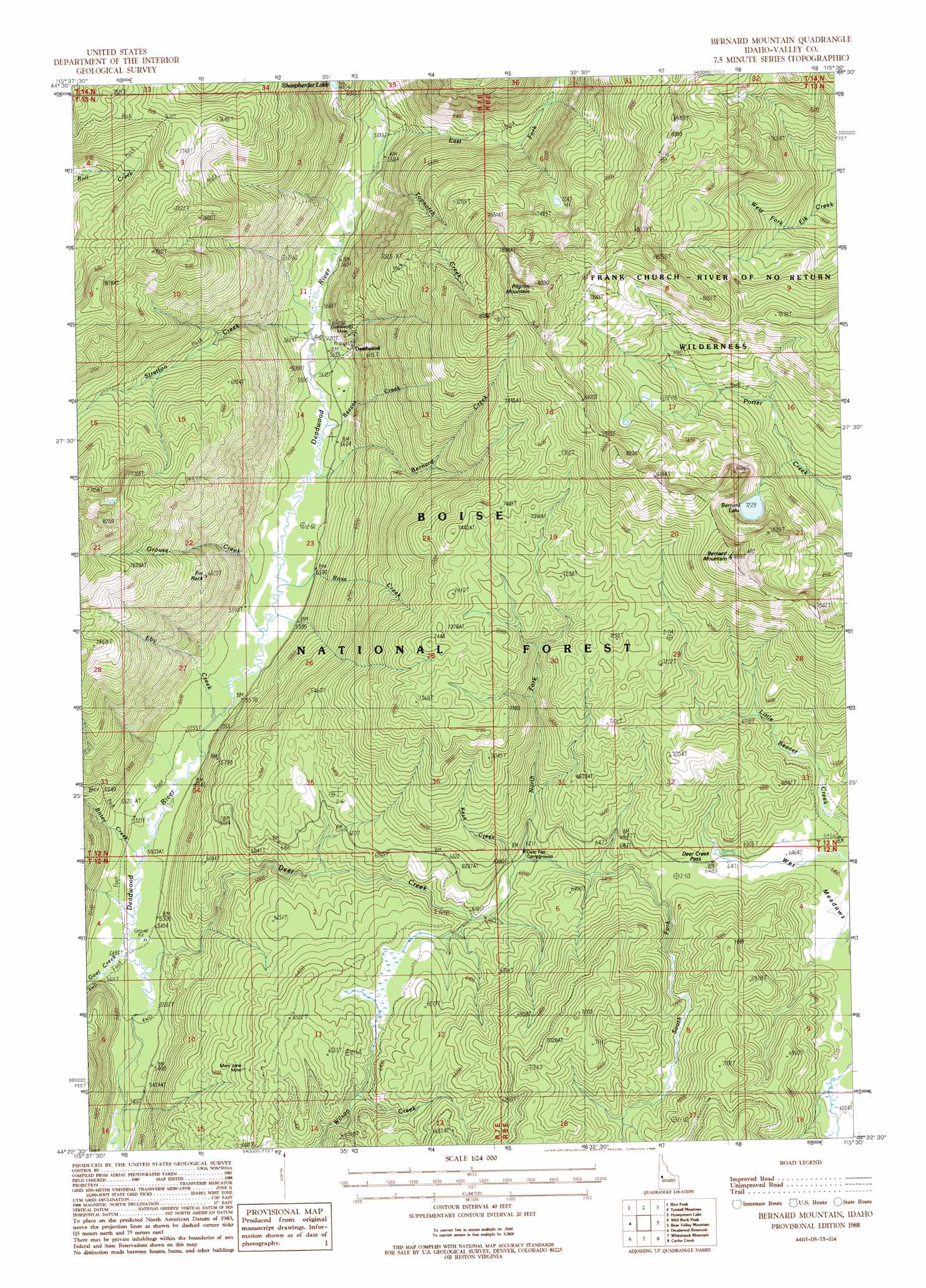
USGS Topo Quad 44115d5 - 1:24,000 scale
| Topo Map Name: | Bernard Mountain |
| USGS Topo Quad ID: | 44115d5 |
| Print Size: | ca. 21 1/4" wide x 27" high |
| Southeast Coordinates: | 44.375° N latitude / 115.5° W longitude |
| Map Center Coordinates: | 44.4375° N latitude / 115.5625° W longitude |
| U.S. State: | ID |
| Filename: | o44115d5.jpg |
| Download Map JPG Image: | Bernard Mountain topo map 1:24,000 scale |
| Map Type: | Topographic |
| Topo Series: | 7.5´ |
| Map Scale: | 1:24,000 |
| Source of Map Images: | United States Geological Survey (USGS) |
| Alternate Map Versions: |
Bernard Mountain ID 1988, updated 1988 Download PDF Buy paper map Bernard Mountain ID 2011 Download PDF Buy paper map Bernard Mountain ID 2013 Download PDF Buy paper map |
| FStopo: | US Forest Service topo Bernard Mountain is available: Download FStopo PDF Download FStopo TIF |
1:24,000 Topo Quads surrounding Bernard Mountain
Gold Fork Rock |
Warm Lake |
Landmark |
Pistol Lake |
Chinook Mountain |
Oro Mountain |
Rice Peak |
Tyndall Meadows |
Honeymoon Lake |
Big Soldier Mountain |
Bull Creek Hot Springs |
Wild Buck Peak |
Bernard Mountain |
Bear Valley Mountain |
Blue Bunch Mountain |
Boiling Springs |
Deadwood Reservoir |
Whitehawk Mountain |
Cache Creek |
Bull Trout Point |
Lightning Ridge |
Scott Creek |
Miller Mountain West |
Miller Mountain East |
Eightmile Mountain |
> Back to 44115a1 at 1:100,000 scale
> Back to 44114a1 at 1:250,000 scale
> Back to U.S. Topo Maps home
Bernard Mountain topo map: Gazetteer
Bernard Mountain: Flats
Crane Meadow elevation 2218m 7276′Wet Meadows elevation 1972m 6469′
Bernard Mountain: Gaps
Deer Creek Pass elevation 1983m 6505′Bernard Mountain: Lakes
Bernard Lake elevation 2205m 7234′Sheepherder Lake elevation 1834m 6017′
Bernard Mountain: Mines
Deadwood Mine elevation 1833m 6013′Mary Jane Mine elevation 1973m 6473′
Bernard Mountain: Streams
Bernard Creek elevation 1705m 5593′Bitter Creek elevation 1683m 5521′
Deer Creek elevation 1676m 5498′
East Fork Deadwood River elevation 1737m 5698′
Eby Creek elevation 1695m 5561′
Goat Creek elevation 1679m 5508′
Grouse Creek elevation 1707m 5600′
Kesh Creek elevation 1887m 6190′
North Fork Deer Creek elevation 1889m 6197′
Reeves Creek elevation 1706m 5597′
Ross Creek elevation 1707m 5600′
South Fork Deer Creek elevation 1919m 6295′
Stratton Creek elevation 1708m 5603′
Topnotch Creek elevation 1729m 5672′
Bernard Mountain: Summits
Bernard Mountain elevation 2495m 8185′Fin Rock elevation 2072m 6797′
Pilgrim Mountain elevation 2497m 8192′
Bernard Mountain: Trails
Little Beaver Creek Trail elevation 2199m 7214′Porter Creek Trail elevation 2368m 7769′
Rice Peak Trail elevation 2120m 6955′
Wild Buck Trail elevation 1679m 5508′
Bernard Mountain digital topo map on disk
Buy this Bernard Mountain topo map showing relief, roads, GPS coordinates and other geographical features, as a high-resolution digital map file on DVD: