Soldier Creek Topo Map Idaho
To zoom in, hover over the map of Soldier Creek
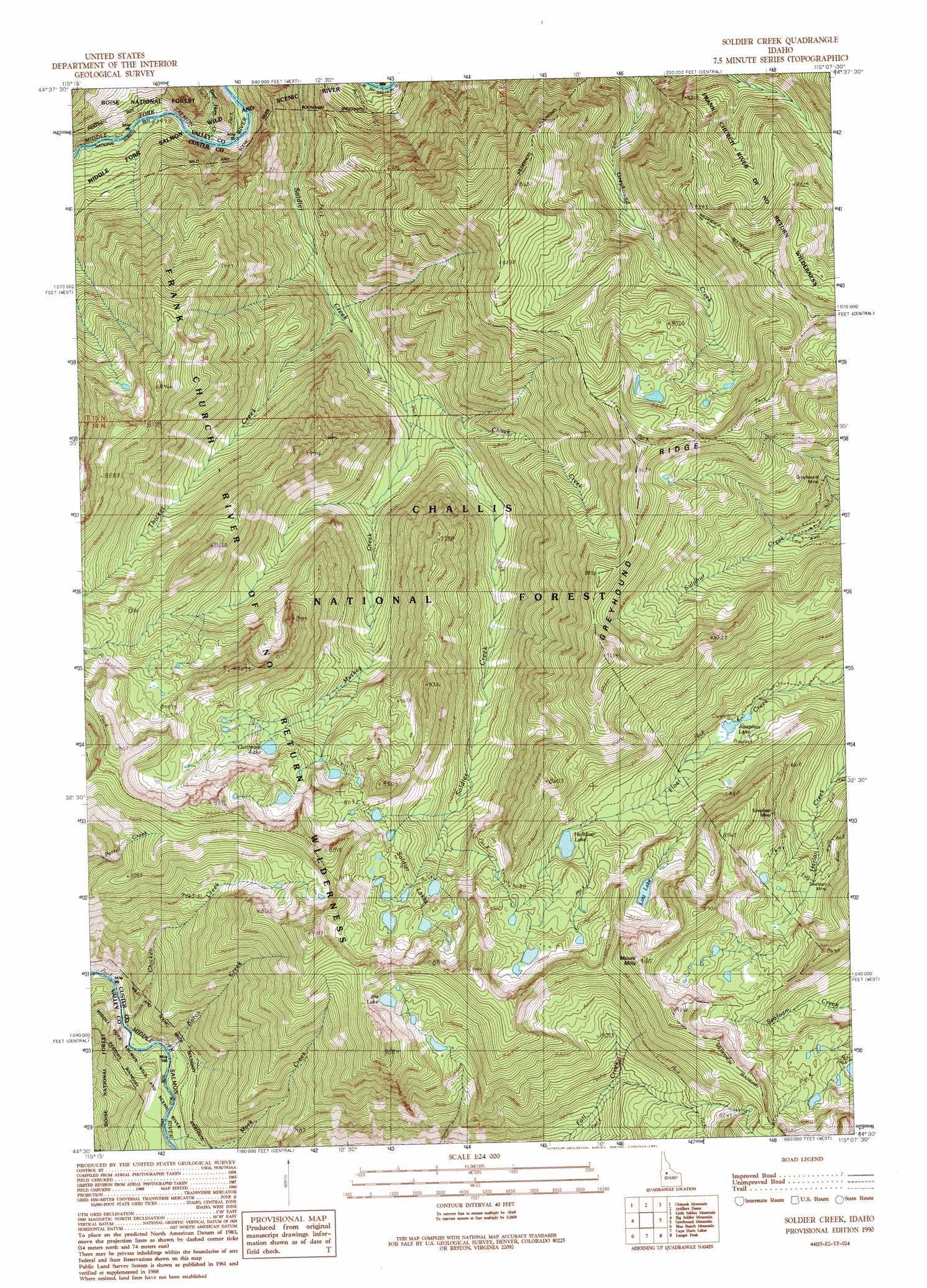
USGS Topo Quad 44115e2 - 1:24,000 scale
| Topo Map Name: | Soldier Creek |
| USGS Topo Quad ID: | 44115e2 |
| Print Size: | ca. 21 1/4" wide x 27" high |
| Southeast Coordinates: | 44.5° N latitude / 115.125° W longitude |
| Map Center Coordinates: | 44.5625° N latitude / 115.1875° W longitude |
| U.S. State: | ID |
| Filename: | o44115e2.jpg |
| Download Map JPG Image: | Soldier Creek topo map 1:24,000 scale |
| Map Type: | Topographic |
| Topo Series: | 7.5´ |
| Map Scale: | 1:24,000 |
| Source of Map Images: | United States Geological Survey (USGS) |
| Alternate Map Versions: |
Soldier Creek ID 1990, updated 1991 Download PDF Buy paper map Soldier Creek ID 1990, updated 1991 Download PDF Buy paper map Soldier Creek ID 2011 Download PDF Buy paper map Soldier Creek ID 2013 Download PDF Buy paper map |
| FStopo: | US Forest Service topo Soldier Creek is available: Download FStopo PDF Download FStopo TIF |
1:24,000 Topo Quads surrounding Soldier Creek
Chilcoot Peak |
Big Chief Creek |
Big Baldy |
Pungo Mountain |
Norton Ridge |
Pistol Lake |
Chinook Mountain |
Artillery Dome |
Little Soldier Mountain |
Sliderock Ridge |
Honeymoon Lake |
Big Soldier Mountain |
Soldier Creek |
Greyhound Mountain |
Pinyon Peak |
Bear Valley Mountain |
Blue Bunch Mountain |
Cape Horn Lakes |
Langer Peak |
Knapp Lakes |
Cache Creek |
Bull Trout Point |
Banner Summit |
Elk Meadow |
Basin Butte |
> Back to 44115e1 at 1:100,000 scale
> Back to 44114a1 at 1:250,000 scale
> Back to U.S. Topo Maps home
Soldier Creek topo map: Gazetteer
Soldier Creek: Lakes
Cutthroat Lake elevation 2341m 7680′Helldiver Lake elevation 2353m 7719′
Iris Lake elevation 2518m 8261′
Josephus Lake elevation 2152m 7060′
Lost Lake elevation 2446m 8024′
Soldier Lakes elevation 2417m 7929′
Soldier Creek: Mines
Greyhound Mine elevation 2277m 7470′Seafoam Mine elevation 2364m 7755′
Silverbell Mine elevation 2394m 7854′
Soldier Creek: Ridges
Greyhound Ridge elevation 2715m 8907′Soldier Creek: Streams
Chicken Creek elevation 1783m 5849′Chuck Creek elevation 1801m 5908′
Deer Horn Creek elevation 1609m 5278′
Kotch Creek elevation 1789m 5869′
Mack Creek elevation 1804m 5918′
Muskeg Creek elevation 1826m 5990′
Thicket Creek elevation 1699m 5574′
Soldier Creek: Summits
Mount Mills elevation 2775m 9104′Soldier Creek digital topo map on disk
Buy this Soldier Creek topo map showing relief, roads, GPS coordinates and other geographical features, as a high-resolution digital map file on DVD: