Little Soldier Mountain Topo Map Idaho
To zoom in, hover over the map of Little Soldier Mountain
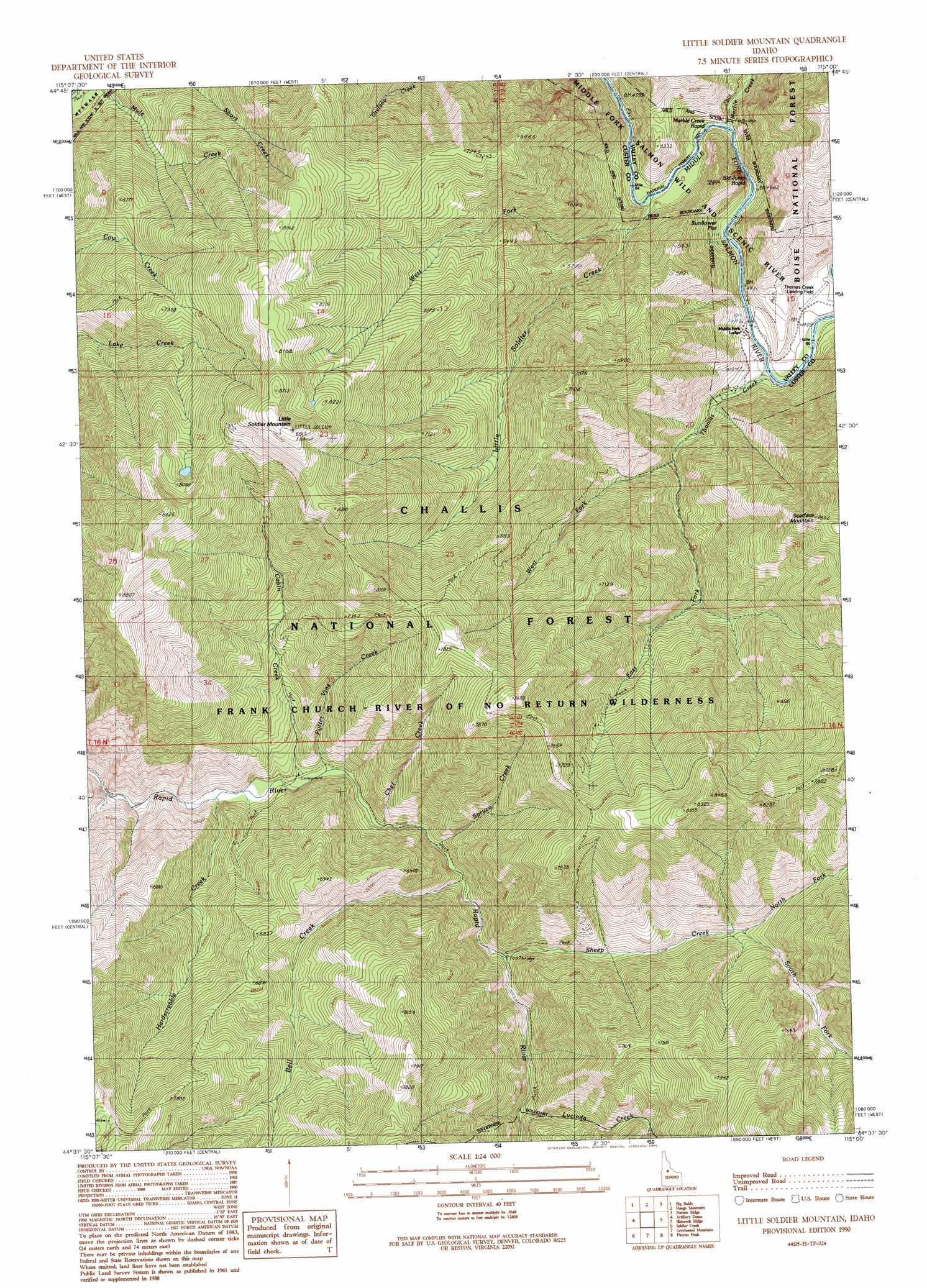
USGS Topo Quad 44115f1 - 1:24,000 scale
| Topo Map Name: | Little Soldier Mountain |
| USGS Topo Quad ID: | 44115f1 |
| Print Size: | ca. 21 1/4" wide x 27" high |
| Southeast Coordinates: | 44.625° N latitude / 115° W longitude |
| Map Center Coordinates: | 44.6875° N latitude / 115.0625° W longitude |
| U.S. State: | ID |
| Filename: | o44115f1.jpg |
| Download Map JPG Image: | Little Soldier Mountain topo map 1:24,000 scale |
| Map Type: | Topographic |
| Topo Series: | 7.5´ |
| Map Scale: | 1:24,000 |
| Source of Map Images: | United States Geological Survey (USGS) |
| Alternate Map Versions: |
Little Soldier Mountain ID 1990, updated 1991 Download PDF Buy paper map Little Soldier Mountain ID 2011 Download PDF Buy paper map Little Soldier Mountain ID 2013 Download PDF Buy paper map |
| FStopo: | US Forest Service topo Little Soldier Mountain is available: Download FStopo PDF Download FStopo TIF |
1:24,000 Topo Quads surrounding Little Soldier Mountain
Stibnite |
Rainbow Peak |
Safety Creek |
Shellrock Peak |
Bear Creek Point |
Big Chief Creek |
Big Baldy |
Pungo Mountain |
Norton Ridge |
Ramey Hill |
Chinook Mountain |
Artillery Dome |
Little Soldier Mountain |
Sliderock Ridge |
Falconberry Peak |
Big Soldier Mountain |
Soldier Creek |
Greyhound Mountain |
Pinyon Peak |
Casto |
Blue Bunch Mountain |
Cape Horn Lakes |
Langer Peak |
Knapp Lakes |
Mount Jordan |
> Back to 44115e1 at 1:100,000 scale
> Back to 44114a1 at 1:250,000 scale
> Back to U.S. Topo Maps home
Little Soldier Mountain topo map: Gazetteer
Little Soldier Mountain: Airports
Thomas Creek Airport elevation 1349m 4425′Little Soldier Mountain: Bridges
Sheep Creek Bridge elevation 1676m 5498′Little Soldier Mountain: Flats
Sunflower Flat elevation 1344m 4409′Little Soldier Mountain: Rapids
Ski Jump Rapid elevation 1349m 4425′Little Soldier Mountain: Streams
Bell Creek elevation 1641m 5383′Cabin Creek elevation 1609m 5278′
Chet Creek elevation 1629m 5344′
East Fork Thomas Creek elevation 1449m 4753′
Hardscrabble Creek elevation 1600m 5249′
Little Soldier Creek elevation 1359m 4458′
Lucinda Creek elevation 1695m 5561′
Marble Creek elevation 1352m 4435′
North Fork Sheep Creek elevation 1828m 5997′
Potter Vine Creek elevation 1615m 5298′
Sheep Creek elevation 1667m 5469′
South Fork Sheep Creek elevation 1829m 6000′
Spruce Creek elevation 1634m 5360′
Thomas Creek elevation 1335m 4379′
West Fork Little Soldier Creek elevation 1407m 4616′
West Fork Thomas Creek elevation 1446m 4744′
Little Soldier Mountain: Summits
Little Soldier Mountain elevation 2686m 8812′Scarface Mountain elevation 2322m 7618′
Little Soldier Mountain digital topo map on disk
Buy this Little Soldier Mountain topo map showing relief, roads, GPS coordinates and other geographical features, as a high-resolution digital map file on DVD: