Landmark Topo Map Idaho
To zoom in, hover over the map of Landmark
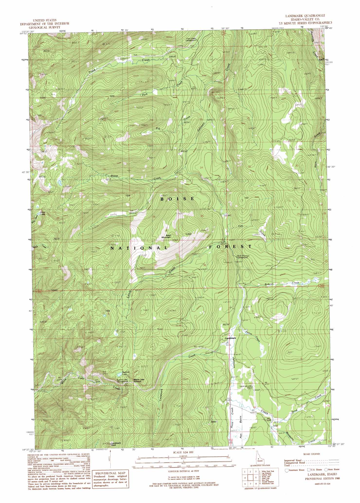
USGS Topo Quad 44115f5 - 1:24,000 scale
| Topo Map Name: | Landmark |
| USGS Topo Quad ID: | 44115f5 |
| Print Size: | ca. 21 1/4" wide x 27" high |
| Southeast Coordinates: | 44.625° N latitude / 115.5° W longitude |
| Map Center Coordinates: | 44.6875° N latitude / 115.5625° W longitude |
| U.S. State: | ID |
| Filename: | o44115f5.jpg |
| Download Map JPG Image: | Landmark topo map 1:24,000 scale |
| Map Type: | Topographic |
| Topo Series: | 7.5´ |
| Map Scale: | 1:24,000 |
| Source of Map Images: | United States Geological Survey (USGS) |
| Alternate Map Versions: |
Landmark ID 1988, updated 1988 Download PDF Buy paper map Landmark ID 2011 Download PDF Buy paper map Landmark ID 2013 Download PDF Buy paper map |
| FStopo: | US Forest Service topo Landmark is available: Download FStopo PDF Download FStopo TIF |
1:24,000 Topo Quads surrounding Landmark
Fitsum Peak |
Teapot Mountain |
Caton Lake |
Yellow Pine |
Stibnite |
Blackmare |
White Rock Peak |
Log Mountain |
Chilcoot Peak |
Big Chief Creek |
Gold Fork Rock |
Warm Lake |
Landmark |
Pistol Lake |
Chinook Mountain |
Oro Mountain |
Rice Peak |
Tyndall Meadows |
Honeymoon Lake |
Big Soldier Mountain |
Bull Creek Hot Springs |
Wild Buck Peak |
Bernard Mountain |
Bear Valley Mountain |
Blue Bunch Mountain |
> Back to 44115e1 at 1:100,000 scale
> Back to 44114a1 at 1:250,000 scale
> Back to U.S. Topo Maps home
Landmark topo map: Gazetteer
Landmark: Airports
Landmark-US Forest Service Airport elevation 2029m 6656′Landmark: Basins
Pen Basin elevation 2024m 6640′Landmark: Lakes
Knox Lake elevation 2326m 7631′Summit Lake elevation 2249m 7378′
Landmark: Pillars
Landmark Rock elevation 2556m 8385′Landmark: Populated Places
Landmark elevation 2021m 6630′Landmark: Streams
Bobcat Creek elevation 2016m 6614′East Fork Burntlog Creek elevation 1811m 5941′
Fan Creek elevation 1996m 6548′
Fulton Creek elevation 2015m 6610′
Landmark Creek elevation 2016m 6614′
Lunch Creek elevation 2000m 6561′
Mosquito Creek elevation 2030m 6660′
Park Creek elevation 1900m 6233′
Pid Creek elevation 1919m 6295′
Rock Creek elevation 2022m 6633′
Sand Creek elevation 2026m 6646′
Sheep Creek elevation 1960m 6430′
Landmark: Summits
Buck Mountain elevation 2364m 7755′Warm Lake Summit elevation 2224m 7296′
Landmark: Trails
Burnt Log Trail elevation 2104m 6902′Trout Creek Trail elevation 2257m 7404′
Landmark digital topo map on disk
Buy this Landmark topo map showing relief, roads, GPS coordinates and other geographical features, as a high-resolution digital map file on DVD: