Blackmare Topo Map Idaho
To zoom in, hover over the map of Blackmare
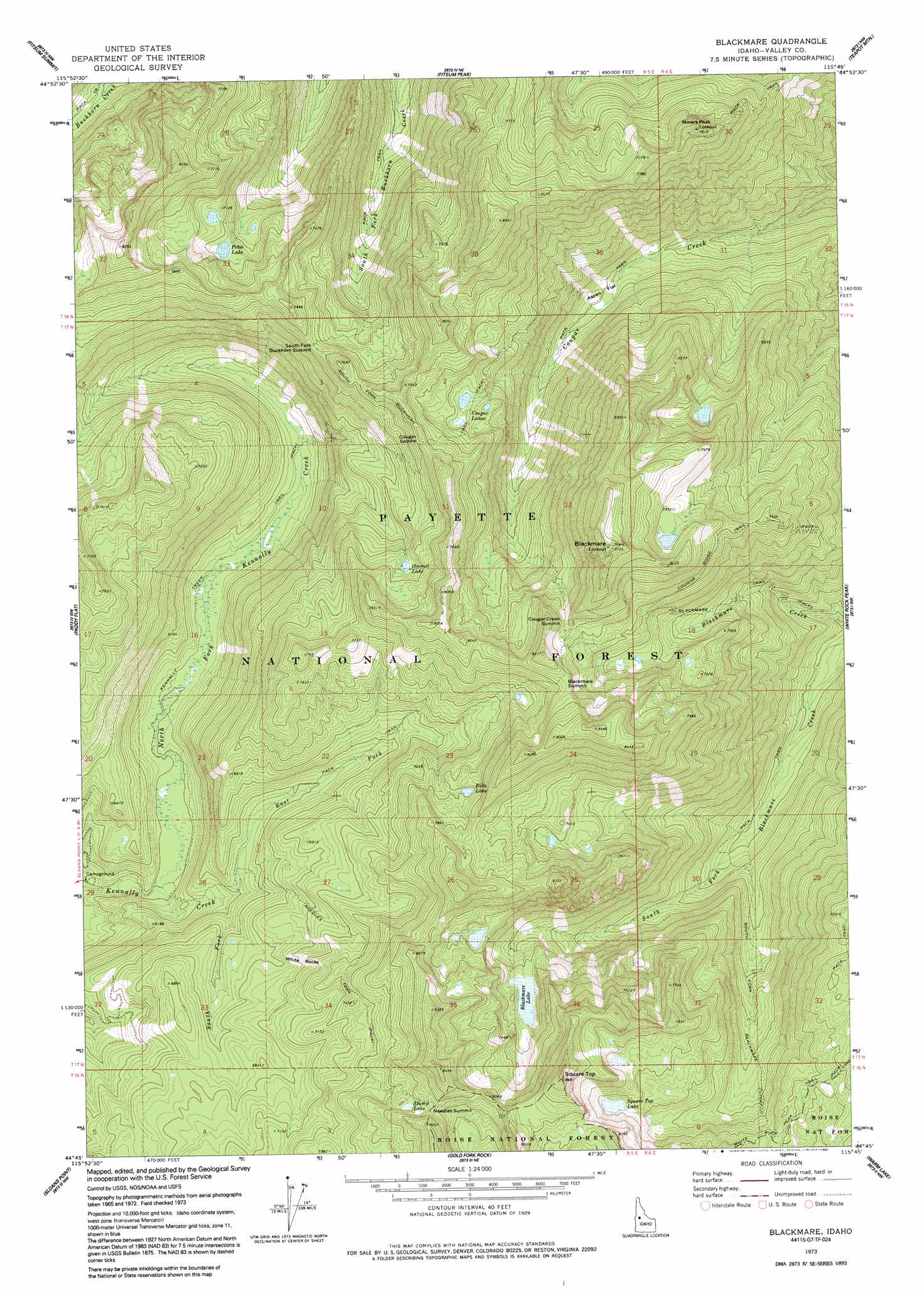
USGS Topo Quad 44115g7 - 1:24,000 scale
| Topo Map Name: | Blackmare |
| USGS Topo Quad ID: | 44115g7 |
| Print Size: | ca. 21 1/4" wide x 27" high |
| Southeast Coordinates: | 44.75° N latitude / 115.75° W longitude |
| Map Center Coordinates: | 44.8125° N latitude / 115.8125° W longitude |
| U.S. State: | ID |
| Filename: | o44115g7.jpg |
| Download Map JPG Image: | Blackmare topo map 1:24,000 scale |
| Map Type: | Topographic |
| Topo Series: | 7.5´ |
| Map Scale: | 1:24,000 |
| Source of Map Images: | United States Geological Survey (USGS) |
| Alternate Map Versions: |
Blackmare ID 1973, updated 1976 Download PDF Buy paper map Blackmare ID 1973, updated 1991 Download PDF Buy paper map Blackmare ID 2004, updated 2007 Download PDF Buy paper map Blackmare ID 2011 Download PDF Buy paper map Blackmare ID 2013 Download PDF Buy paper map |
| FStopo: | US Forest Service topo Blackmare is available: Download FStopo PDF Download FStopo TIF |
1:24,000 Topo Quads surrounding Blackmare
Granite Lake |
Box Lake |
Enos Lake |
Williams Peak |
Parks Peak |
Mccall |
Fitsum Summit |
Fitsum Peak |
Teapot Mountain |
Caton Lake |
Lake Fork |
Paddy Flat |
Blackmare |
White Rock Peak |
Log Mountain |
Donnelly |
Sloans Point |
Gold Fork Rock |
Warm Lake |
Landmark |
Cascade |
Eagle Nest |
Oro Mountain |
Rice Peak |
Tyndall Meadows |
> Back to 44115e1 at 1:100,000 scale
> Back to 44114a1 at 1:250,000 scale
> Back to U.S. Topo Maps home
Blackmare topo map: Gazetteer
Blackmare: Flats
Aspen Flat elevation 1772m 5813′Blackmare: Gaps
Blackmare Summit elevation 2409m 7903′Cougar Creek Summit elevation 2373m 7785′
Cougar Saddle elevation 2332m 7650′
Needles Summit elevation 2409m 7903′
South Fork Buckhorn Summit elevation 2233m 7326′
Blackmare: Lakes
Bills Lake elevation 2254m 7395′Cougar Lakes elevation 2173m 7129′
Dismal Lake elevation 2215m 7267′
Petes Lake elevation 2119m 6952′
Square Top Lake elevation 2229m 7312′
Stump Lake elevation 2375m 7791′
Blackmare: Pillars
White Rocks elevation 2122m 6961′Blackmare: Reservoirs
Blackmare Lake elevation 2141m 7024′Blackmare: Springs
Hot Spring elevation 2386m 7828′Blackmare: Streams
East Fork Kennally Creek elevation 1888m 6194′North Fork Kennally Creek elevation 1758m 5767′
South Fork Kennally Creek elevation 1860m 6102′
Blackmare: Summits
Blackmare elevation 2640m 8661′Miners Peak elevation 2378m 7801′
Square Top elevation 2634m 8641′
Blackmare: Trails
Kennally Creek Trail elevation 1814m 5951′Needles Trail elevation 2221m 7286′
South Fork Blackmare Cutoff elevation 1939m 6361′
South Fork Buckhorn Trail elevation 2287m 7503′
White Rock Peak Trail elevation 2287m 7503′
Blackmare digital topo map on disk
Buy this Blackmare topo map showing relief, roads, GPS coordinates and other geographical features, as a high-resolution digital map file on DVD: