Paddy Flat Topo Map Idaho
To zoom in, hover over the map of Paddy Flat
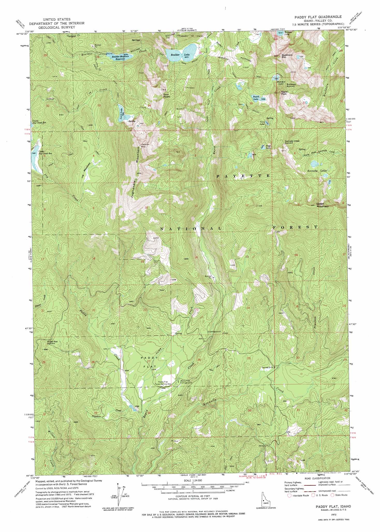
USGS Topo Quad 44115g8 - 1:24,000 scale
| Topo Map Name: | Paddy Flat |
| USGS Topo Quad ID: | 44115g8 |
| Print Size: | ca. 21 1/4" wide x 27" high |
| Southeast Coordinates: | 44.75° N latitude / 115.875° W longitude |
| Map Center Coordinates: | 44.8125° N latitude / 115.9375° W longitude |
| U.S. State: | ID |
| Filename: | o44115g8.jpg |
| Download Map JPG Image: | Paddy Flat topo map 1:24,000 scale |
| Map Type: | Topographic |
| Topo Series: | 7.5´ |
| Map Scale: | 1:24,000 |
| Source of Map Images: | United States Geological Survey (USGS) |
| Alternate Map Versions: |
Paddy Flat ID 1973, updated 1977 Download PDF Buy paper map Paddy Flat ID 1973, updated 1977 Download PDF Buy paper map Paddy Flat ID 2004, updated 2007 Download PDF Buy paper map Paddy Flat ID 2011 Download PDF Buy paper map Paddy Flat ID 2013 Download PDF Buy paper map |
| FStopo: | US Forest Service topo Paddy Flat is available: Download FStopo PDF Download FStopo TIF |
1:24,000 Topo Quads surrounding Paddy Flat
Brundage Mountain |
Granite Lake |
Box Lake |
Enos Lake |
Williams Peak |
Meadows |
Mccall |
Fitsum Summit |
Fitsum Peak |
Teapot Mountain |
No Business Mountain |
Lake Fork |
Paddy Flat |
Blackmare |
White Rock Peak |
Lone Tree |
Donnelly |
Sloans Point |
Gold Fork Rock |
Warm Lake |
Cold Spring Ridge |
Cascade |
Eagle Nest |
Oro Mountain |
Rice Peak |
> Back to 44115e1 at 1:100,000 scale
> Back to 44114a1 at 1:250,000 scale
> Back to U.S. Topo Maps home
Paddy Flat topo map: Gazetteer
Paddy Flat: Dams
Boulder Lake Dam elevation 2125m 6971′Boulder Meadow Dam elevation 1912m 6272′
Louie Lake Dam elevation 2137m 7011′
Paddy Flat: Flats
Jug Meadows elevation 1973m 6473′Paddy Flat elevation 1622m 5321′
Paddy Flat: Lakes
Fogg Lake elevation 2243m 7358′Kennally Lakes elevation 2207m 7240′
Malony Lake elevation 2200m 7217′
Rapid Lake elevation 2208m 7244′
Summit Lake elevation 2303m 7555′
Vics Lake elevation 2316m 7598′
Paddy Flat: Reservoirs
Boulder Lake elevation 2125m 6971′Boulder Meadows Reservoir elevation 1912m 6272′
Louie Lake elevation 2137m 7011′
Upper Jug Creek Reservoir elevation 1697m 5567′
Paddy Flat: Streams
Camp Creek elevation 1596m 5236′Paddy Creek elevation 1589m 5213′
Powelson Creek elevation 1657m 5436′
Sapphire Creek elevation 1608m 5275′
Paddy Flat: Summits
Buckhorn Mountain elevation 2578m 8458′Buckhorn Summit elevation 2392m 7847′
Green Mountain elevation 2444m 8018′
Jughandle Mountain elevation 2450m 8038′
Kennally Creek Summit elevation 2412m 7913′
Paddy Flat Summit elevation 1798m 5898′
Rapid Peak elevation 2517m 8257′
Twin Peaks elevation 2392m 7847′
Paddy Flat: Trails
Boulder Lake Trail elevation 2042m 6699′Buckhorn Trail elevation 2276m 7467′
Louie Lake Trail elevation 1937m 6354′
Paddy Flat Lake Fork Trail elevation 2117m 6945′
Paddy Flat digital topo map on disk
Buy this Paddy Flat topo map showing relief, roads, GPS coordinates and other geographical features, as a high-resolution digital map file on DVD: