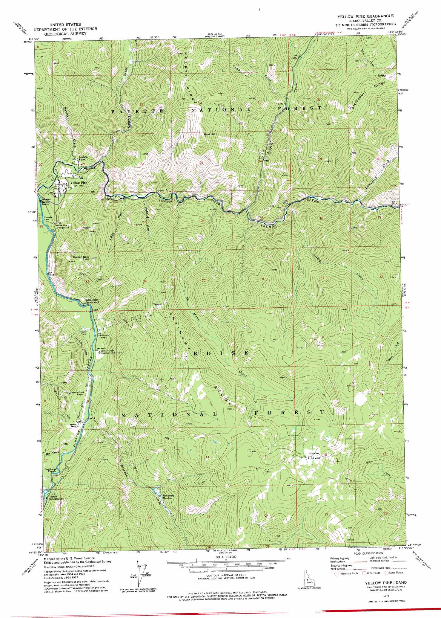
Yellow Pine Topo Map Idaho
To zoom in, hover over the map of Yellow Pine
USGS Topo Quad 44115h4 - 1:24,000 scale
| Topo Map Name: | Yellow Pine |
| USGS Topo Quad ID: | 44115h4 |
| Print Size: | ca. 21 1/4" wide x 27" high |
| Southeast Coordinates: | 44.875° N latitude / 115.375° W longitude |
| Map Center Coordinates: | 44.9375° N latitude / 115.4375° W longitude |
| U.S. State: | ID |
| Filename: | o44115h4.jpg |
| Download Map JPG Image: | Yellow Pine topo map 1:24,000 scale |
| Map Type: | Topographic |
| Topo Series: | 7.5´ |
| Map Scale: | 1:24,000 |
| Source of Map Images: | United States Geological Survey (USGS) |
| Alternate Map Versions: |
Yellow Pine ID 1973, updated 1976 Download PDF Buy paper map Yellow Pine ID 1973, updated 1976 Download PDF Buy paper map Yellow Pine ID 2004, updated 2007 Download PDF Buy paper map Yellow Pine ID 2011 Download PDF Buy paper map Yellow Pine ID 2013 Download PDF Buy paper map |
| FStopo: | US Forest Service topo Yellow Pine is available: Download FStopo PDF Download FStopo TIF |
1:24,000 Topo Quads surrounding Yellow Pine
Pony Meadows |
Pilot Peak |
Wolf Fang Peak |
Big Creek |
Bismark Mountain |
Williams Peak |
Parks Peak |
Profile Gap |
Edwardsburg |
Center Mountain |
Teapot Mountain |
Caton Lake |
Yellow Pine |
Stibnite |
Rainbow Peak |
White Rock Peak |
Log Mountain |
Chilcoot Peak |
Big Chief Creek |
Big Baldy |
Warm Lake |
Landmark |
Pistol Lake |
Chinook Mountain |
Artillery Dome |
> Back to 44115e1 at 1:100,000 scale
> Back to 44114a1 at 1:250,000 scale
> Back to U.S. Topo Maps home
Yellow Pine topo map: Gazetteer
Yellow Pine: Airports
Johnson Creek Airport elevation 1497m 4911′Yellow Pine: Flats
Hennessey Meadow elevation 1850m 6069′Yellow Pine: Lakes
Caton Lake elevation 2427m 7962′Yellow Pine: Populated Places
Abstein Place elevation 1510m 4954′Yellow Pine elevation 1452m 4763′
Yellow Pine: Post Offices
Yellow Pine Post Office (historical) elevation 1452m 4763′Yellow Pine: Rapids
Deadhorse Rapids elevation 1532m 5026′Yellow Pine: Ridges
Antimony Ridge elevation 2347m 7700′Yellow Pine: Streams
Bishop Creek elevation 1626m 5334′Boulder Creek elevation 1458m 4783′
Camp Creek elevation 1737m 5698′
Double A Creek elevation 1527m 5009′
Hot Creek elevation 1509m 4950′
No Mans Creek elevation 1573m 5160′
Olson Creek elevation 1536m 5039′
Profile Creek elevation 1593m 5226′
Quartz Creek elevation 1501m 4924′
Riordan Creek elevation 1504m 4934′
Tamarack Creek elevation 1668m 5472′
Vibika Creek elevation 1525m 5003′
Yellow Pine: Summits
Bald Hill elevation 2346m 7696′Golden Gate Hill elevation 2051m 6729′
Yellow Pine digital topo map on disk
Buy this Yellow Pine topo map showing relief, roads, GPS coordinates and other geographical features, as a high-resolution digital map file on DVD: