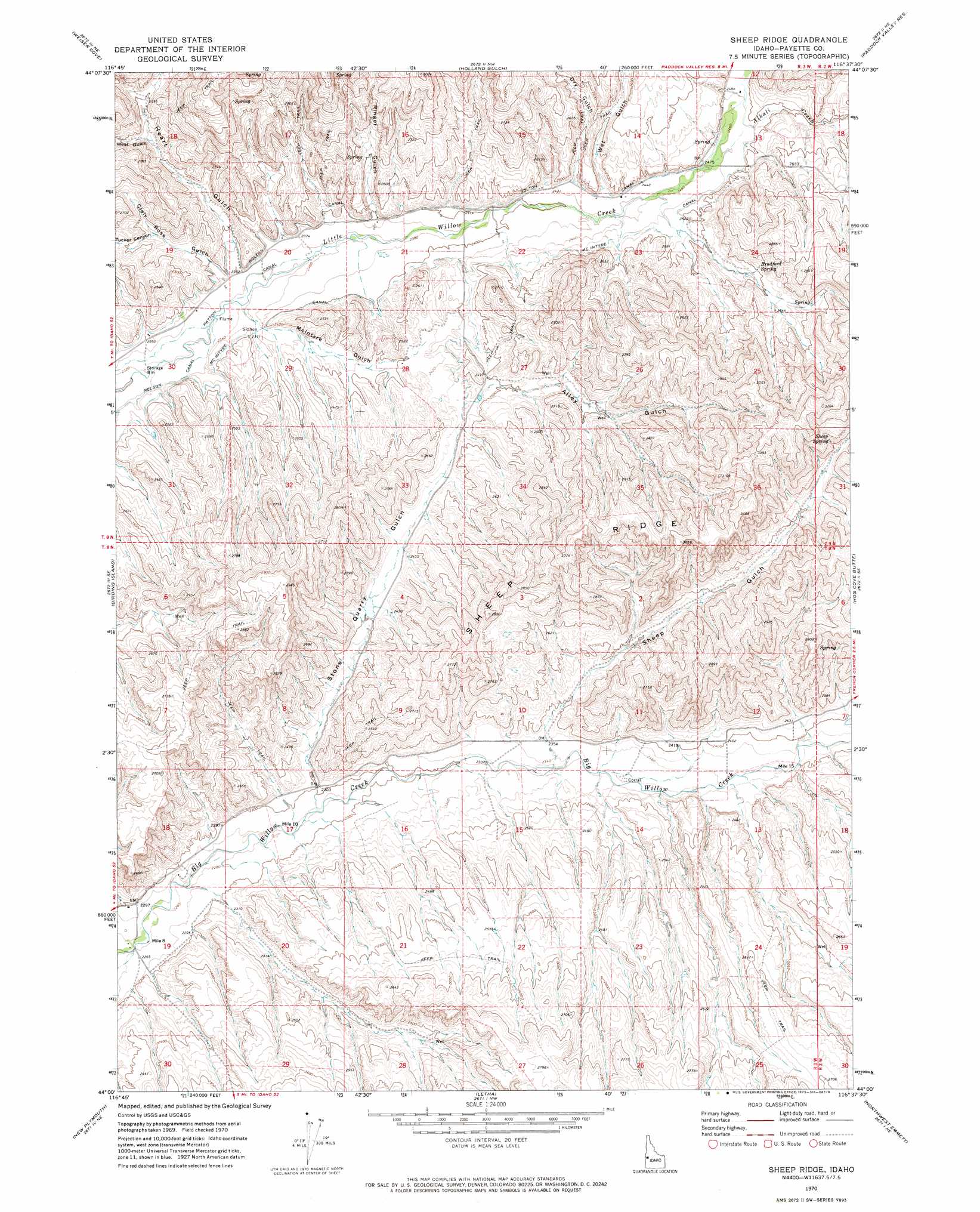
Sheep Ridge Topo Map Idaho
To zoom in, hover over the map of Sheep Ridge
USGS Topo Quad 44116a6 - 1:24,000 scale
| Topo Map Name: | Sheep Ridge |
| USGS Topo Quad ID: | 44116a6 |
| Print Size: | ca. 21 1/4" wide x 27" high |
| Southeast Coordinates: | 44° N latitude / 116.625° W longitude |
| Map Center Coordinates: | 44.0625° N latitude / 116.6875° W longitude |
| U.S. State: | ID |
| Filename: | o44116a6.jpg |
| Download Map JPG Image: | Sheep Ridge topo map 1:24,000 scale |
| Map Type: | Topographic |
| Topo Series: | 7.5´ |
| Map Scale: | 1:24,000 |
| Source of Map Images: | United States Geological Survey (USGS) |
| Alternate Map Versions: |
Sheep Ridge ID 1970, updated 1973 Download PDF Buy paper map Sheep Ridge ID 2010 Download PDF Buy paper map Sheep Ridge ID 2013 Download PDF Buy paper map |
1:24,000 Topo Quads surrounding Sheep Ridge
Weiser North |
Mann Creek Se |
Nutmeg Flat |
Crane Creek Reservoir |
Riley Butte |
Weiser South |
Weiser Cove |
Holland Gulch |
Paddock Valley Reservoir |
Coonrod Gulch |
Payette |
Birding Island |
Sheep Ridge |
Hog Cove Butte |
Squaw Butte |
Nyssa |
New Plymouth |
Letha |
Northwest Emmett |
Northeast Emmett |
Parma |
Parma Se |
Sand Hollow |
Southwest Emmett |
Southeast Emmett |
> Back to 44116a1 at 1:100,000 scale
> Back to 44116a1 at 1:250,000 scale
> Back to U.S. Topo Maps home
Sheep Ridge topo map: Gazetteer
Sheep Ridge: Canals
McIntyre Canal elevation 728m 2388′Sheep Ridge: Populated Places
French (historical) elevation 759m 2490′Sheep Ridge: Ridges
Sheep Ridge elevation 934m 3064′Sheep Ridge: Springs
Bradford Spring elevation 800m 2624′Sheep Spring elevation 872m 2860′
Sheep Ridge: Streams
Alkali Creek elevation 748m 2454′Sheep Ridge: Valleys
Alley Gulch elevation 781m 2562′Clair Rose Gulch elevation 727m 2385′
Dry Gulch elevation 752m 2467′
Heart Gulch elevation 729m 2391′
McIntyre Gulch elevation 715m 2345′
Ringer Gulch elevation 735m 2411′
Sheep Gulch elevation 720m 2362′
Stone Quarry Gulch elevation 696m 2283′
Tucker Canyon elevation 747m 2450′
West Gulch elevation 771m 2529′
Wet Gulch elevation 744m 2440′
Sheep Ridge digital topo map on disk
Buy this Sheep Ridge topo map showing relief, roads, GPS coordinates and other geographical features, as a high-resolution digital map file on DVD: