Smiths Ferry Topo Map Idaho
To zoom in, hover over the map of Smiths Ferry
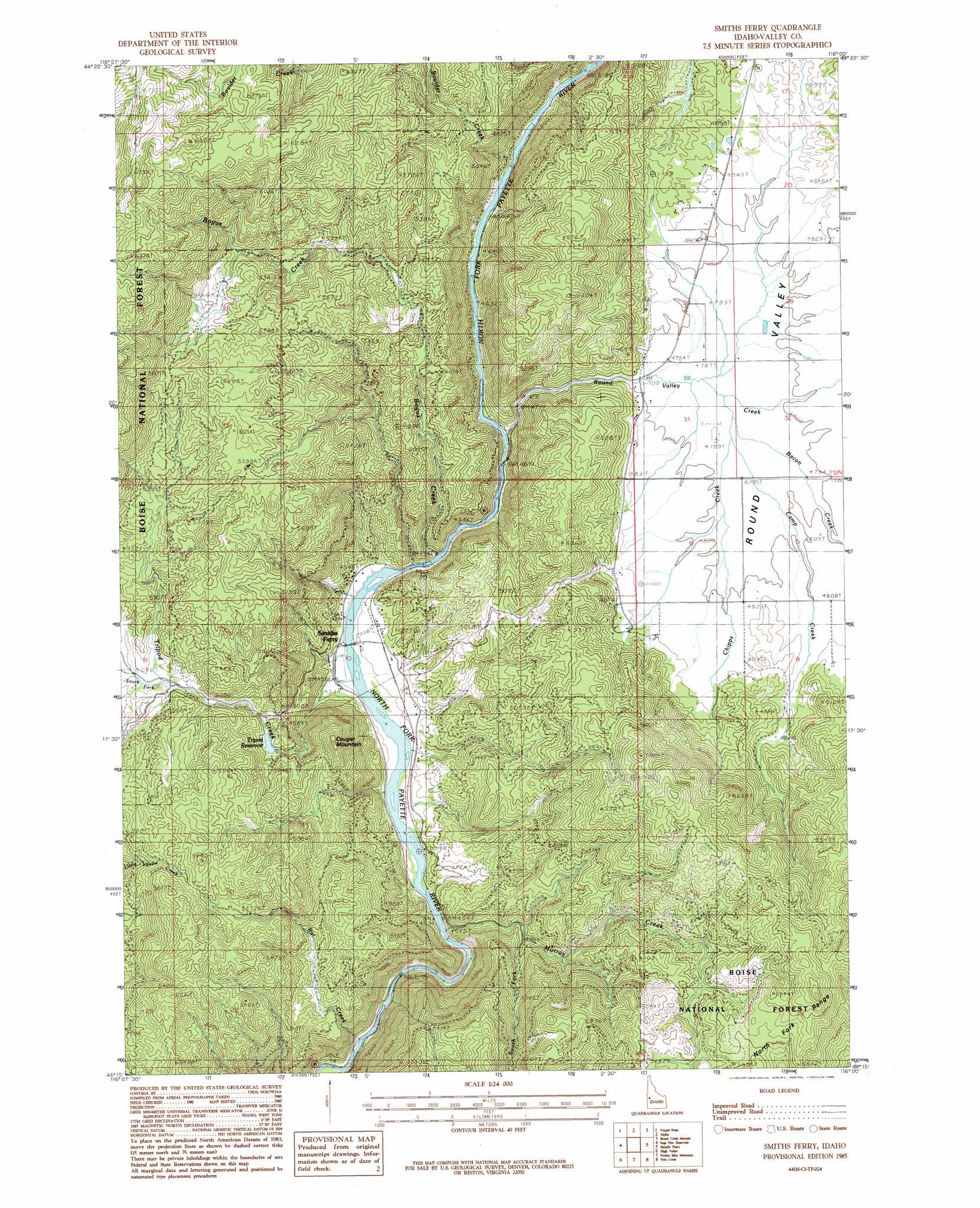
USGS Topo Quad 44116c1 - 1:24,000 scale
| Topo Map Name: | Smiths Ferry |
| USGS Topo Quad ID: | 44116c1 |
| Print Size: | ca. 21 1/4" wide x 27" high |
| Southeast Coordinates: | 44.25° N latitude / 116° W longitude |
| Map Center Coordinates: | 44.3125° N latitude / 116.0625° W longitude |
| U.S. State: | ID |
| Filename: | o44116c1.jpg |
| Download Map JPG Image: | Smiths Ferry topo map 1:24,000 scale |
| Map Type: | Topographic |
| Topo Series: | 7.5´ |
| Map Scale: | 1:24,000 |
| Source of Map Images: | United States Geological Survey (USGS) |
| Alternate Map Versions: |
Smiths Ferry ID 1985, updated 1986 Download PDF Buy paper map Smiths Ferry ID 2011 Download PDF Buy paper map Smiths Ferry ID 2013 Download PDF Buy paper map |
| FStopo: | US Forest Service topo Smiths Ferry is available: Download FStopo PDF Download FStopo TIF |
1:24,000 Topo Quads surrounding Smiths Ferry
King Hill Creek |
Cold Spring Ridge |
Cascade |
Eagle Nest |
Oro Mountain |
Twin Sisters |
Tripod Peak |
Alpha |
Skunk Creek Summit |
Bull Creek Hot Springs |
Dodson Pass |
Sage Hen Reservoir |
Smiths Ferry |
Sixmile Point |
Boiling Springs |
Ola |
High Valley |
Packer John Mountain |
Pyle Creek |
Lightning Ridge |
Webb Creek |
Dry Buck Valley |
Banks |
Garden Valley |
Grimes Pass |
> Back to 44116a1 at 1:100,000 scale
> Back to 44116a1 at 1:250,000 scale
> Back to U.S. Topo Maps home
Smiths Ferry topo map: Gazetteer
Smiths Ferry: Dams
Tripod Dam elevation 1517m 4977′Smiths Ferry: Populated Places
Smiths Ferry elevation 1388m 4553′Smiths Ferry: Reservoirs
Tripod Reservoir elevation 1517m 4977′Smiths Ferry: Streams
Bacon Creek elevation 1462m 4796′Bogus Creek elevation 1387m 4550′
Boulder Creek elevation 1415m 4642′
Camp Creek elevation 1463m 4799′
Chipps Creek elevation 1461m 4793′
Murray Creek elevation 1373m 4504′
Rat Creek elevation 1316m 4317′
Round Valley Creek elevation 1396m 4580′
South Fork Murray Creek elevation 1455m 4773′
South Fork Tripod Creek elevation 1555m 5101′
Tripod Creek elevation 1378m 4520′
Smiths Ferry: Summits
Cougar Mountain elevation 1634m 5360′Smiths Ferry: Valleys
Round Valley elevation 1466m 4809′Smiths Ferry digital topo map on disk
Buy this Smiths Ferry topo map showing relief, roads, GPS coordinates and other geographical features, as a high-resolution digital map file on DVD: