Mccall Topo Map Idaho
To zoom in, hover over the map of Mccall
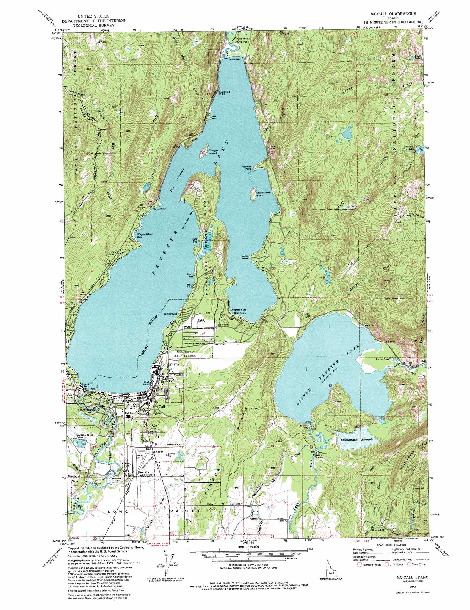
USGS Topo Quad 44116h1 - 1:24,000 scale
| Topo Map Name: | Mccall |
| USGS Topo Quad ID: | 44116h1 |
| Print Size: | ca. 21 1/4" wide x 27" high |
| Southeast Coordinates: | 44.875° N latitude / 116° W longitude |
| Map Center Coordinates: | 44.9375° N latitude / 116.0625° W longitude |
| U.S. State: | ID |
| Filename: | o44116h1.jpg |
| Download Map JPG Image: | Mccall topo map 1:24,000 scale |
| Map Type: | Topographic |
| Topo Series: | 7.5´ |
| Map Scale: | 1:24,000 |
| Source of Map Images: | United States Geological Survey (USGS) |
| Alternate Map Versions: |
McCall ID 1973, updated 1977 Download PDF Buy paper map McCall ID 1973, updated 1977 Download PDF Buy paper map Mc Call ID 1973, updated 1985 Download PDF Buy paper map Mc Call ID 1973, updated 1985 Download PDF Buy paper map McCall ID 1973, updated 1985 Download PDF Buy paper map McCall ID 2004, updated 2007 Download PDF Buy paper map McCall ID 2011 Download PDF Buy paper map McCall ID 2013 Download PDF Buy paper map |
| FStopo: | US Forest Service topo McCall is available: Download FStopo PDF Download FStopo TIF |
1:24,000 Topo Quads surrounding Mccall
Indian Mountain |
Hazard Lake |
Black Tip |
Victor Peak |
Loon Lake |
Bally Mountain |
Brundage Mountain |
Granite Lake |
Box Lake |
Enos Lake |
New Meadows |
Meadows |
Mccall |
Fitsum Summit |
Fitsum Peak |
Cold Spring Summit |
No Business Mountain |
Lake Fork |
Paddy Flat |
Blackmare |
Council Mountain |
Lone Tree |
Donnelly |
Sloans Point |
Gold Fork Rock |
> Back to 44116e1 at 1:100,000 scale
> Back to 44116a1 at 1:250,000 scale
> Back to U.S. Topo Maps home
Mccall topo map: Gazetteer
Mccall: Airports
McCall Airport elevation 1531m 5022′McCall Memorial Hospital Heliport elevation 1531m 5022′
Saint Josephs Regional Medical Center Heliport elevation 1531m 5022′
Mccall: Bays
Duck Bay elevation 1521m 4990′Huckleberry Bay elevation 1521m 4990′
Pilgrim Cove elevation 1521m 4990′
Wagon Wheel Bay elevation 1521m 4990′
Mccall: Beaches
North Beach elevation 1522m 4993′Sylvan Beach elevation 1525m 5003′
Mccall: Bridges
Sheep Bridge elevation 1500m 4921′Mccall: Canals
Stringer Ditch elevation 1533m 5029′Mccall: Capes
Lucks Point elevation 1525m 5003′Paradise Point elevation 1521m 4990′
Porcupine Point elevation 1570m 5150′
Mccall: Channels
The Narrows elevation 1521m 4990′Mccall: Cliffs
Lightning Point elevation 1555m 5101′Mccall: Dams
Knox Meadow Dam elevation 1556m 5104′Little Payette Lake Dam elevation 1560m 5118′
Rio Vista Dam elevation 1529m 5016′
Mccall: Islands
Cougar Island elevation 1540m 5052′Shellworth Island elevation 1528m 5013′
Mccall: Lakes
Black Lake elevation 2140m 7020′Blackwell Lake elevation 2011m 6597′
Payette Lake elevation 1521m 4990′
Squaw Lake elevation 2189m 7181′
Mccall: Parks
Ponderosa State Park elevation 1557m 5108′Mccall: Populated Places
Elo (historical) elevation 1554m 5098′McCall elevation 1528m 5013′
Mccall: Reservoirs
Cruickshank Reservoir elevation 1556m 5104′Little Payette Lake elevation 1560m 5118′
Mccall: Ridges
Timber Ridge elevation 1587m 5206′Mccall: Streams
Duston Creek elevation 1561m 5121′Fall Creek elevation 1521m 4990′
Jacks Creek elevation 1598m 5242′
Jumbo Creek elevation 1561m 5121′
Landing Creek elevation 1767m 5797′
Lemah Creek elevation 1521m 4990′
Ping Creek elevation 1521m 4990′
Sylvan Creek elevation 1525m 5003′
Tyee Creek elevation 1562m 5124′
Wagon Bay Creek elevation 1522m 4993′
Williams Creek elevation 1498m 4914′
Mccall: Swamps
Lily Marsh elevation 1529m 5016′Mccall digital topo map on disk
Buy this Mccall topo map showing relief, roads, GPS coordinates and other geographical features, as a high-resolution digital map file on DVD: