Juniper Mountain Topo Map Oregon
To zoom in, hover over the map of Juniper Mountain
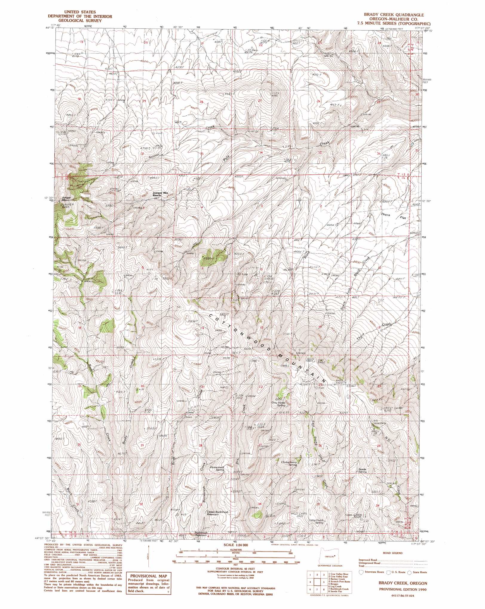
USGS Topo Quad 44117b6 - 1:24,000 scale
| Topo Map Name: | Juniper Mountain |
| USGS Topo Quad ID: | 44117b6 |
| Print Size: | ca. 21 1/4" wide x 27" high |
| Southeast Coordinates: | 44.125° N latitude / 117.625° W longitude |
| Map Center Coordinates: | 44.1875° N latitude / 117.6875° W longitude |
| U.S. State: | OR |
| Filename: | o44117b6.jpg |
| Download Map JPG Image: | Juniper Mountain topo map 1:24,000 scale |
| Map Type: | Topographic |
| Topo Series: | 7.5´ |
| Map Scale: | 1:24,000 |
| Source of Map Images: | United States Geological Survey (USGS) |
| Alternate Map Versions: |
Brady Creek OR 1990, updated 1990 Download PDF Buy paper map Brady Creek OR 2011 Download PDF Buy paper map Brady Creek OR 2014 Download PDF Buy paper map |
1:24,000 Topo Quads surrounding Juniper Mountain
Devils Heel |
Wendt Butte |
Bridgeport |
Mormon Basin |
Rye Valley |
Ironside |
Cow Valley West |
Cow Valley East |
Becker Creek |
Birch Creek Meadow |
Clover Creek Ranch |
Scratch Post Mountain |
Juniper Mountain |
Brogan |
Jamieson |
Little Juniper Spring |
Log Creek |
Buckbrush Creek |
Swede Flat |
Hope Butte |
Westfall Butte |
Little Black Canyon |
Westfall |
Little Valley |
Vines Hill |
> Back to 44117a1 at 1:100,000 scale
> Back to 44116a1 at 1:250,000 scale
> Back to U.S. Topo Maps home
Juniper Mountain topo map: Gazetteer
Juniper Mountain: Flats
Thorn Flat elevation 1299m 4261′Juniper Mountain: Ranges
Cottonwood Mountain elevation 1974m 6476′Juniper Mountain: Reservoirs
Buckbrush Reservoir elevation 1379m 4524′Upper Buckbrush Reservoir elevation 1437m 4714′
Juniper Mountain: Springs
Antelope Spring elevation 1555m 5101′Chokecherry Spring elevation 1677m 5501′
East Prong Spring elevation 1900m 6233′
Grey Horse Spring elevation 1808m 5931′
Homestead Spring elevation 1549m 5082′
Long Gulch Spring elevation 1597m 5239′
Swede Spring elevation 1829m 6000′
Juniper Mountain: Streams
Brady Creek elevation 1265m 4150′Brian Creek elevation 1260m 4133′
South Fork Pole Creek elevation 1168m 3832′
Suitter Creek elevation 1229m 4032′
Juniper Mountain: Summits
Juniper Mountain elevation 1942m 6371′Juniper Mountain digital topo map on disk
Buy this Juniper Mountain topo map showing relief, roads, GPS coordinates and other geographical features, as a high-resolution digital map file on DVD: