Cow Valley West Topo Map Oregon
To zoom in, hover over the map of Cow Valley West
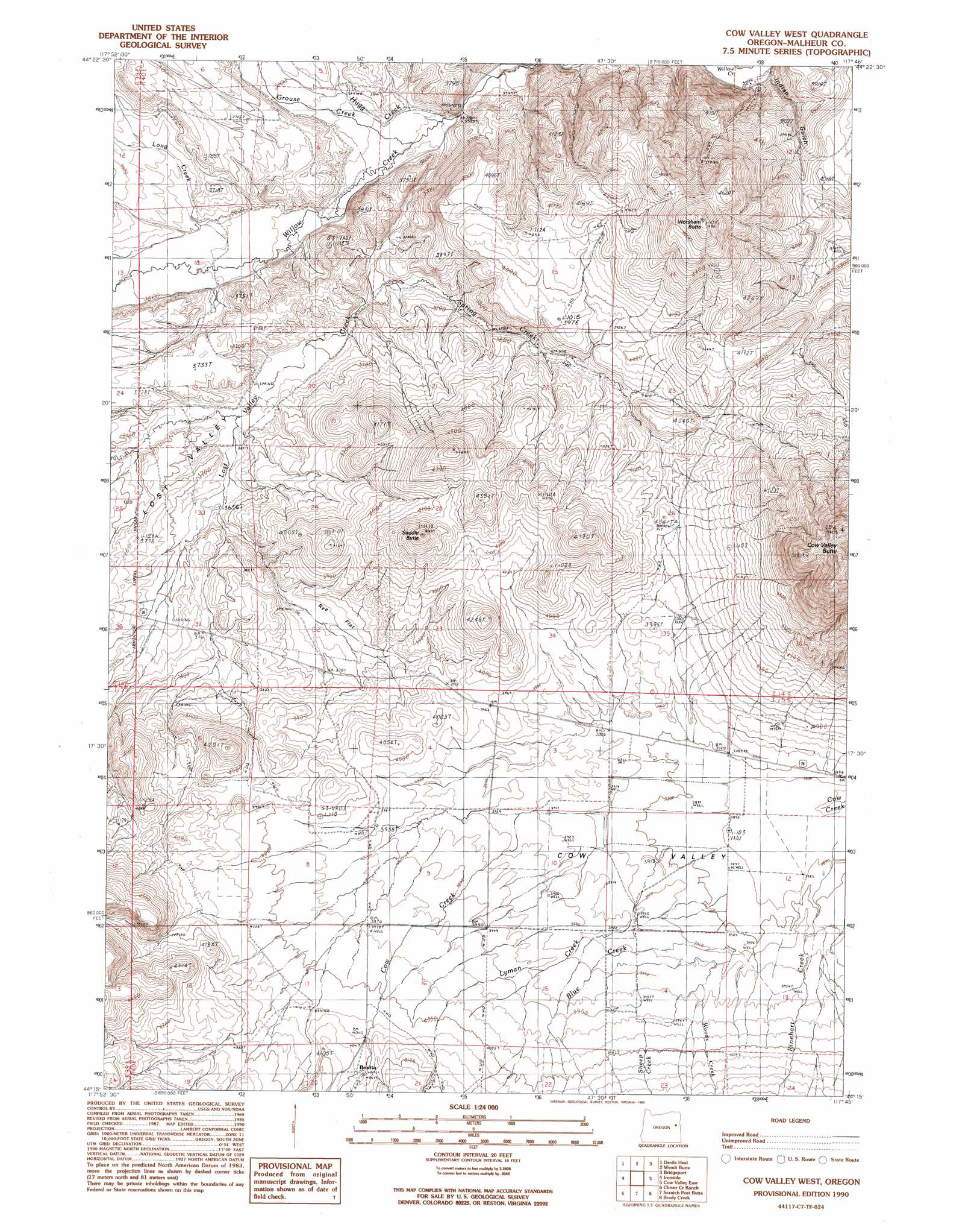
USGS Topo Quad 44117c7 - 1:24,000 scale
| Topo Map Name: | Cow Valley West |
| USGS Topo Quad ID: | 44117c7 |
| Print Size: | ca. 21 1/4" wide x 27" high |
| Southeast Coordinates: | 44.25° N latitude / 117.75° W longitude |
| Map Center Coordinates: | 44.3125° N latitude / 117.8125° W longitude |
| U.S. State: | OR |
| Filename: | o44117c7.jpg |
| Download Map JPG Image: | Cow Valley West topo map 1:24,000 scale |
| Map Type: | Topographic |
| Topo Series: | 7.5´ |
| Map Scale: | 1:24,000 |
| Source of Map Images: | United States Geological Survey (USGS) |
| Alternate Map Versions: |
Cow Valley West OR 1990, updated 1990 Download PDF Buy paper map Cow Valley West OR 2011 Download PDF Buy paper map Cow Valley West OR 2014 Download PDF Buy paper map |
1:24,000 Topo Quads surrounding Cow Valley West
Beaverdam Creek |
Brannan Gulch |
Dooley Mountain |
French Gulch |
Lost Basin |
Hereford |
Devils Heel |
Wendt Butte |
Bridgeport |
Mormon Basin |
Eldorado Pass |
Ironside |
Cow Valley West |
Cow Valley East |
Becker Creek |
De Bord Peaks |
Clover Creek Ranch |
Scratch Post Mountain |
Juniper Mountain |
Brogan |
Hunter Mtn |
Little Juniper Spring |
Log Creek |
Buckbrush Creek |
Swede Flat |
> Back to 44117a1 at 1:100,000 scale
> Back to 44116a1 at 1:250,000 scale
> Back to U.S. Topo Maps home
Cow Valley West topo map: Gazetteer
Cow Valley West: Flats
Rye Flat elevation 1146m 3759′Cow Valley West: Populated Places
Bonita elevation 1239m 4064′Cow Valley West: Post Offices
Bonita Post Office (historical) elevation 1239m 4064′Cow Valley West: Reservoirs
Moltham Reservoir Five elevation 1294m 4245′Cow Valley West: Springs
Hugg Spring elevation 1092m 3582′Cow Valley West: Streams
Blue Creek elevation 1192m 3910′Grouse Creek elevation 1074m 3523′
Hugg Creek elevation 1074m 3523′
Long Creek elevation 1098m 3602′
Lost Valley Creek elevation 1092m 3582′
Lyman Creek elevation 1187m 3894′
Rinehart Creek elevation 1185m 3887′
Sheep Creek elevation 1222m 4009′
Spring Creek elevation 1093m 3585′
Woods Creek elevation 1193m 3914′
Cow Valley West: Summits
Cow Valley Butte elevation 1641m 5383′Saddle Butte elevation 1336m 4383′
Worsham Butte elevation 1465m 4806′
Cow Valley West: Valleys
Indian Gulch elevation 1117m 3664′Lost Valley elevation 1108m 3635′
Cow Valley West digital topo map on disk
Buy this Cow Valley West topo map showing relief, roads, GPS coordinates and other geographical features, as a high-resolution digital map file on DVD: