Bridgeport Topo Map Oregon
To zoom in, hover over the map of Bridgeport
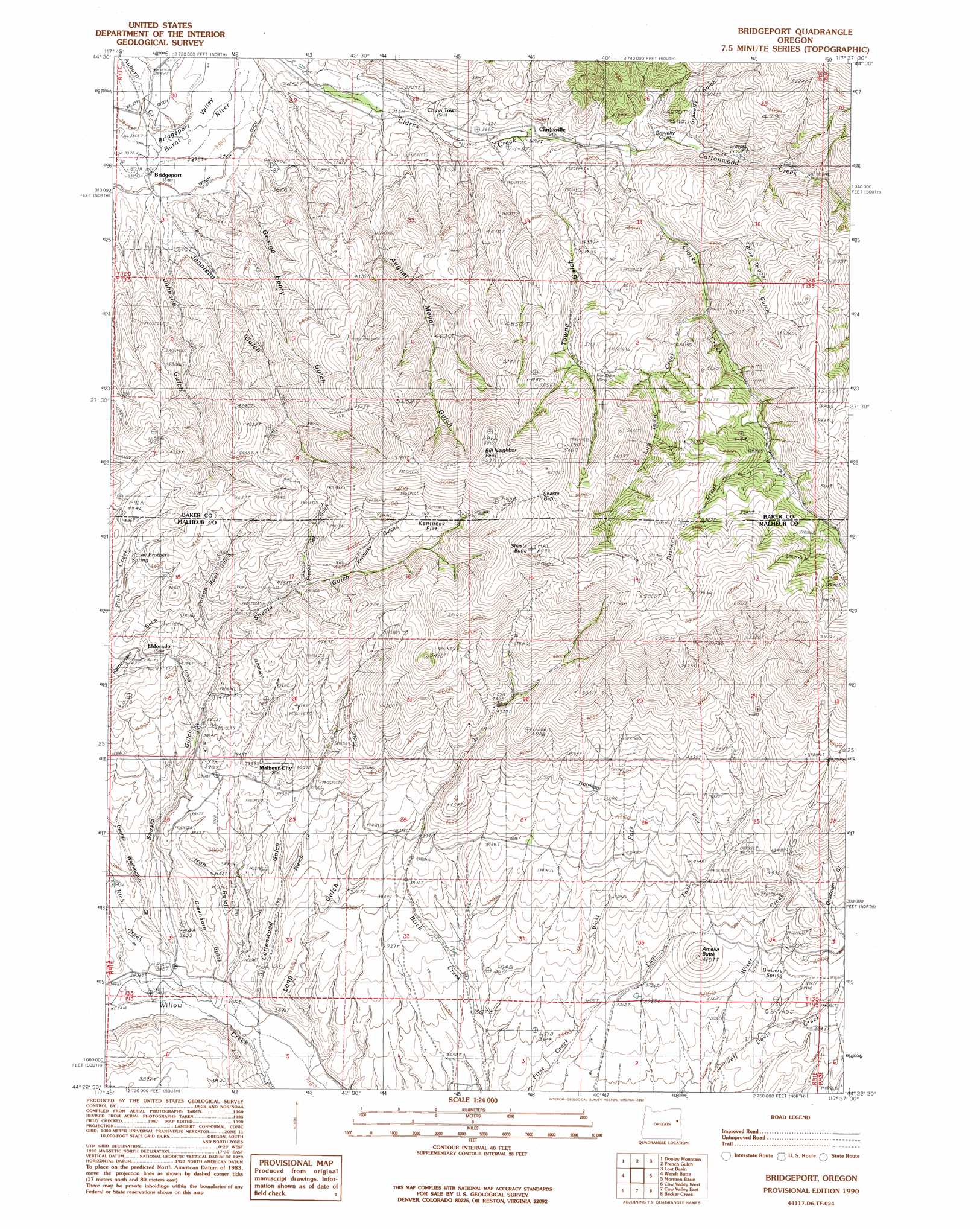
USGS Topo Quad 44117d6 - 1:24,000 scale
| Topo Map Name: | Bridgeport |
| USGS Topo Quad ID: | 44117d6 |
| Print Size: | ca. 21 1/4" wide x 27" high |
| Southeast Coordinates: | 44.375° N latitude / 117.625° W longitude |
| Map Center Coordinates: | 44.4375° N latitude / 117.6875° W longitude |
| U.S. State: | OR |
| Filename: | o44117d6.jpg |
| Download Map JPG Image: | Bridgeport topo map 1:24,000 scale |
| Map Type: | Topographic |
| Topo Series: | 7.5´ |
| Map Scale: | 1:24,000 |
| Source of Map Images: | United States Geological Survey (USGS) |
| Alternate Map Versions: |
Bridgeport OR 1990, updated 1990 Download PDF Buy paper map Bridgeport OR 2011 Download PDF Buy paper map Bridgeport OR 2014 Download PDF Buy paper map |
| FStopo: | US Forest Service topo Bridgeport is available: Download FStopo PDF Download FStopo TIF |
1:24,000 Topo Quads surrounding Bridgeport
Blue Canyon |
Bowen Valley |
Encina |
Oxman |
Lawrence Creek |
Brannan Gulch |
Dooley Mountain |
French Gulch |
Lost Basin |
Durkee |
Devils Heel |
Wendt Butte |
Bridgeport |
Mormon Basin |
Rye Valley |
Ironside |
Cow Valley West |
Cow Valley East |
Becker Creek |
Birch Creek Meadow |
Clover Creek Ranch |
Scratch Post Mountain |
Juniper Mountain |
Brogan |
Jamieson |
> Back to 44117a1 at 1:100,000 scale
> Back to 44116a1 at 1:250,000 scale
> Back to U.S. Topo Maps home
Bridgeport topo map: Gazetteer
Bridgeport: Basins
Gravelly Cove elevation 1225m 4019′Bridgeport: Canals
Birch Creek Ditch elevation 1149m 3769′Lynns Ditch elevation 1217m 3992′
Morfitt Ditch elevation 1039m 3408′
Wendt Ditch elevation 1037m 3402′
Bridgeport: Flats
Kentucky Flat elevation 1526m 5006′Bridgeport: Gaps
Shasta Gap elevation 1792m 5879′Bridgeport: Mines
Iron Door Mine elevation 1536m 5039′Bridgeport: Populated Places
Bridgeport elevation 1033m 3389′China Town elevation 1082m 3549′
Clarksville elevation 1129m 3704′
Eldorado elevation 1254m 4114′
Malheur City (historical) elevation 1201m 3940′
Bridgeport: Post Offices
Bridgeport Post Office elevation 1033m 3389′Clarksville Post Office (historical) elevation 1129m 3704′
El Dorado Post Office (historical) elevation 1254m 4114′
Malheur Post Office (historical) elevation 1201m 3940′
Bridgeport: Springs
Brewery Spring elevation 1196m 3923′Racey Brothers Spring elevation 1302m 4271′
Shasta Spring elevation 1572m 5157′
Tub Spring elevation 1466m 4809′
Bridgeport: Streams
Auburn Creek elevation 1030m 3379′Brinker Creek elevation 1485m 4872′
Cottonwood Creek elevation 1186m 3891′
East Fork First Creek elevation 1103m 3618′
Log Town Creek elevation 1328m 4356′
Marble Creek elevation 1063m 3487′
Rich Creek elevation 1047m 3435′
West Fork First Creek elevation 1103m 3618′
Wiser Creek elevation 1104m 3622′
Bridgeport: Summits
Amelia Butte elevation 1281m 4202′Bill Neighbor Peak elevation 1820m 5971′
Shasta Butte elevation 1854m 6082′
Bridgeport: Valleys
August Meyer Gulch elevation 1073m 3520′Blue Trigger Gulch elevation 1290m 4232′
Cottonwood Gulch elevation 1044m 3425′
Deadman Gulch elevation 1241m 4071′
Freeze Out Gulch elevation 1328m 4356′
French Gulch elevation 1133m 3717′
George Henry Gulch elevation 1059m 3474′
George Washington Gulch elevation 1073m 3520′
Gravelly Gulch elevation 1208m 3963′
Greenhorn Gulch elevation 1047m 3435′
Iron Gulch elevation 1047m 3435′
Jennison Gulch elevation 1058m 3471′
Johnson Gulch elevation 1050m 3444′
Kentucky Gulch elevation 1393m 4570′
Long Gulch elevation 1036m 3398′
Poison Root Gulch elevation 1223m 4012′
Quartz Gulch elevation 1044m 3425′
Shasta Gulch elevation 1050m 3444′
Towne Gulch elevation 1123m 3684′
Bridgeport digital topo map on disk
Buy this Bridgeport topo map showing relief, roads, GPS coordinates and other geographical features, as a high-resolution digital map file on DVD: