Wendt Butte Topo Map Oregon
To zoom in, hover over the map of Wendt Butte
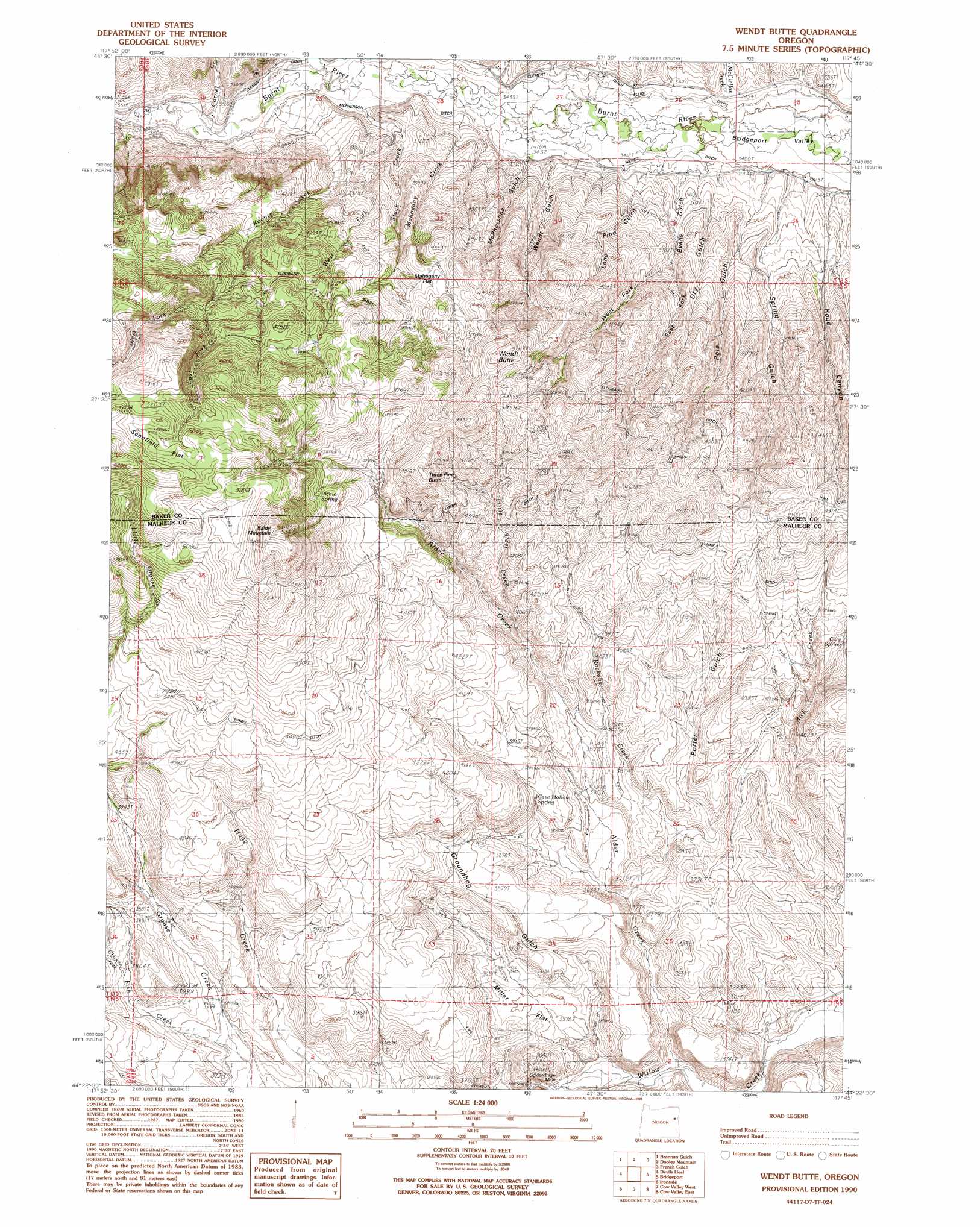
USGS Topo Quad 44117d7 - 1:24,000 scale
| Topo Map Name: | Wendt Butte |
| USGS Topo Quad ID: | 44117d7 |
| Print Size: | ca. 21 1/4" wide x 27" high |
| Southeast Coordinates: | 44.375° N latitude / 117.75° W longitude |
| Map Center Coordinates: | 44.4375° N latitude / 117.8125° W longitude |
| U.S. State: | OR |
| Filename: | o44117d7.jpg |
| Download Map JPG Image: | Wendt Butte topo map 1:24,000 scale |
| Map Type: | Topographic |
| Topo Series: | 7.5´ |
| Map Scale: | 1:24,000 |
| Source of Map Images: | United States Geological Survey (USGS) |
| Alternate Map Versions: |
Wendt Butte OR 1990, updated 1990 Download PDF Buy paper map Wendt Butte OR 2011 Download PDF Buy paper map Wendt Butte OR 2014 Download PDF Buy paper map |
| FStopo: | US Forest Service topo Wendt Butte is available: Download FStopo PDF Download FStopo TIF |
1:24,000 Topo Quads surrounding Wendt Butte
Phillips Lake |
Blue Canyon |
Bowen Valley |
Encina |
Oxman |
Beaverdam Creek |
Brannan Gulch |
Dooley Mountain |
French Gulch |
Lost Basin |
Hereford |
Devils Heel |
Wendt Butte |
Bridgeport |
Mormon Basin |
Eldorado Pass |
Ironside |
Cow Valley West |
Cow Valley East |
Becker Creek |
De Bord Peaks |
Clover Creek Ranch |
Scratch Post Mountain |
Juniper Mountain |
Brogan |
> Back to 44117a1 at 1:100,000 scale
> Back to 44116a1 at 1:250,000 scale
> Back to U.S. Topo Maps home
Wendt Butte topo map: Gazetteer
Wendt Butte: Canals
Clarks Creek Ditch elevation 1108m 3635′Clement Ditch elevation 1084m 3556′
Elliot Ditch elevation 1043m 3421′
Lynns Ditch elevation 1376m 4514′
McPherson Ditch elevation 1053m 3454′
Mill Ditch elevation 1089m 3572′
Wendt Butte: Flats
Mahogany Flat elevation 1307m 4288′Miller Flat elevation 1098m 3602′
Schofield Flat elevation 1595m 5232′
Wendt Butte: Gaps
Shasta Gap elevation 1123m 3684′Wendt Butte: Mines
Golden Eagle Mine elevation 1119m 3671′Wendt Butte: Reservoirs
Pole Gulch Reservoir elevation 1203m 3946′Wendt Butte: Springs
Cary Spring elevation 1240m 4068′Cave Hollow Spring elevation 1163m 3815′
Nickols Spring elevation 1341m 4399′
Picnic Spring elevation 1473m 4832′
Wendt Butte: Streams
Alder Creek elevation 1053m 3454′Chicken Creek elevation 1164m 3818′
Cornet Creek elevation 1060m 3477′
Dry Grouse Creek elevation 1357m 4452′
East Fork Koontz Creek elevation 1387m 4550′
Fish Creek elevation 1114m 3654′
Koontz Creek elevation 1059m 3474′
Little Alder Creek elevation 1199m 3933′
Mahogany Creek elevation 1054m 3458′
McClellan Creek elevation 1053m 3454′
Mill Creek elevation 1059m 3474′
Miller Creek elevation 1066m 3497′
Rockaby Creek elevation 1098m 3602′
Stack Creek elevation 1059m 3474′
West Fork Koontz Creek elevation 1387m 4550′
West Fork Stack Creek elevation 1106m 3628′
Wendt Butte: Summits
Baldy Mountain elevation 1649m 5410′Three Pine Butte elevation 1454m 4770′
Wendt Butte elevation 1439m 4721′
Wendt Butte: Valleys
Cave Hollow elevation 1123m 3684′Dry Gulch elevation 1040m 3412′
East Fork Evans Gulch elevation 1109m 3638′
Evans Gulch elevation 1049m 3441′
Glasgow Gulch elevation 1060m 3477′
Groundhog Gulch elevation 1060m 3477′
Indian Gulch elevation 1049m 3441′
Lone Pine Gulch elevation 1052m 3451′
McPherson Gulch elevation 1067m 3500′
Pole Gulch elevation 1038m 3405′
Porter Gulch elevation 1123m 3684′
Rattlesnake Gulch elevation 1183m 3881′
Road Canyon elevation 1040m 3412′
Spring Gulch elevation 1044m 3425′
Wendt Gulch elevation 1049m 3441′
West Fork Evans Gulch elevation 1109m 3638′
Wendt Butte digital topo map on disk
Buy this Wendt Butte topo map showing relief, roads, GPS coordinates and other geographical features, as a high-resolution digital map file on DVD: