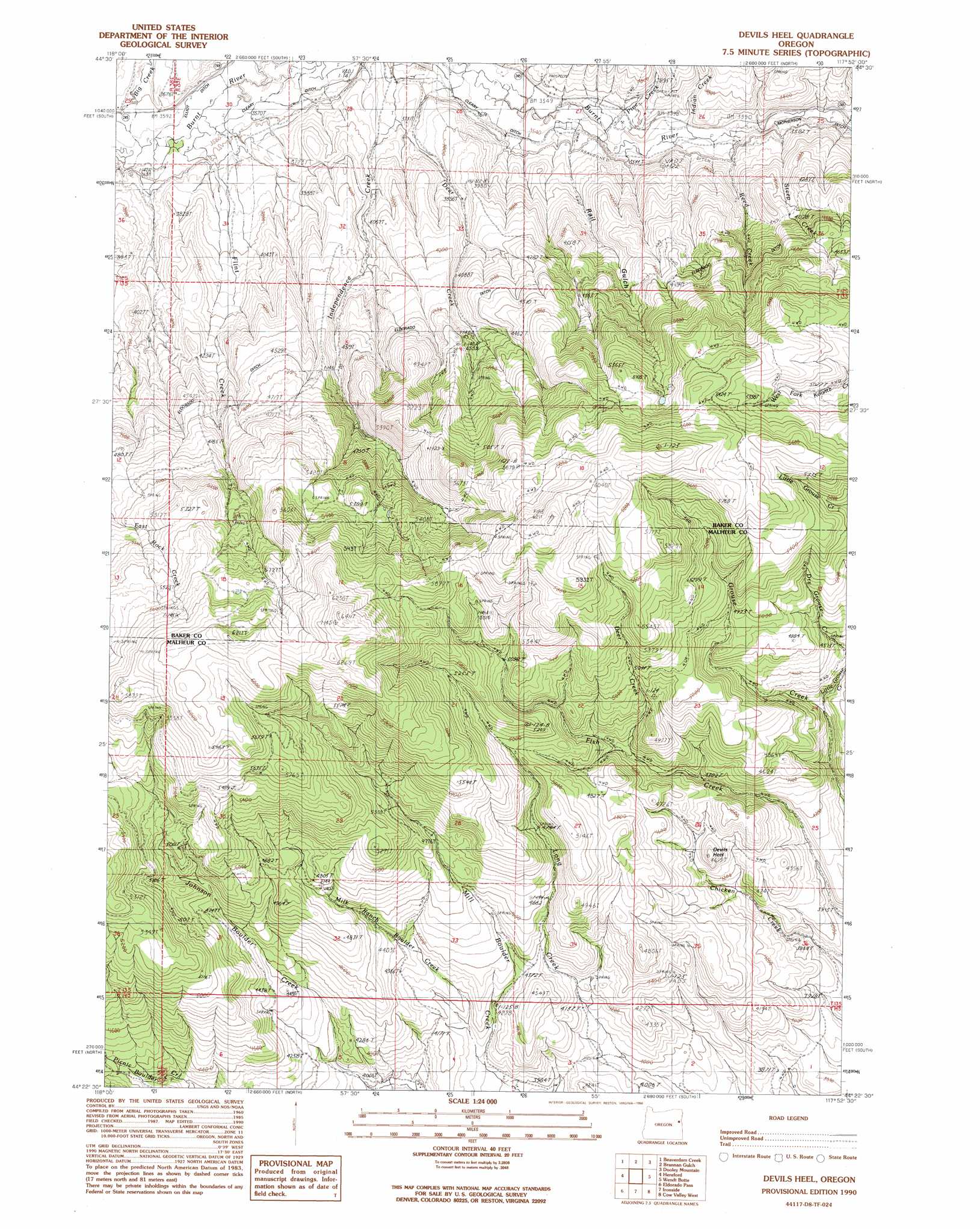
Devils Heel Topo Map Oregon
To zoom in, hover over the map of Devils Heel
USGS Topo Quad 44117d8 - 1:24,000 scale
| Topo Map Name: | Devils Heel |
| USGS Topo Quad ID: | 44117d8 |
| Print Size: | ca. 21 1/4" wide x 27" high |
| Southeast Coordinates: | 44.375° N latitude / 117.875° W longitude |
| Map Center Coordinates: | 44.4375° N latitude / 117.9375° W longitude |
| U.S. State: | OR |
| Filename: | o44117d8.jpg |
| Download Map JPG Image: | Devils Heel topo map 1:24,000 scale |
| Map Type: | Topographic |
| Topo Series: | 7.5´ |
| Map Scale: | 1:24,000 |
| Source of Map Images: | United States Geological Survey (USGS) |
| Alternate Map Versions: |
Devils Heel OR 1990, updated 1990 Download PDF Buy paper map Devils Heel OR 2011 Download PDF Buy paper map Devils Heel OR 2014 Download PDF Buy paper map |
| FStopo: | US Forest Service topo Devils Heel is available: Download FStopo PDF Download FStopo TIF |
1:24,000 Topo Quads surrounding Devils Heel
Sumpter |
Phillips Lake |
Blue Canyon |
Bowen Valley |
Encina |
Unity Reservoir |
Beaverdam Creek |
Brannan Gulch |
Dooley Mountain |
French Gulch |
Unity |
Hereford |
Devils Heel |
Wendt Butte |
Bridgeport |
Rastus Mountain |
Eldorado Pass |
Ironside |
Cow Valley West |
Cow Valley East |
Clevenger Butte |
De Bord Peaks |
Clover Creek Ranch |
Scratch Post Mountain |
Juniper Mountain |
> Back to 44117a1 at 1:100,000 scale
> Back to 44116a1 at 1:250,000 scale
> Back to U.S. Topo Maps home
Devils Heel topo map: Gazetteer
Devils Heel: Canals
Independence Creek Ditch elevation 1193m 3914′Reeds Ditch elevation 1082m 3549′
Devils Heel: Pillars
Devils Heel elevation 1330m 4363′Devils Heel: Streams
Big Creek elevation 1092m 3582′Deer Creek elevation 1379m 4524′
Deer Creek elevation 1081m 3546′
Flint Creek elevation 1091m 3579′
Independence Creek elevation 1101m 3612′
Indian Creek elevation 1073m 3520′
Little Grouse Creek elevation 1361m 4465′
Milk Ranch Boulder Creek elevation 1213m 3979′
Outhouse Creek elevation 1110m 3641′
Pine Creek elevation 1076m 3530′
Reed Creek elevation 1073m 3520′
Steep Creek elevation 1068m 3503′
Devils Heel: Valleys
Rail Gulch elevation 1122m 3681′Devils Heel digital topo map on disk
Buy this Devils Heel topo map showing relief, roads, GPS coordinates and other geographical features, as a high-resolution digital map file on DVD: