Durkee Topo Map Oregon
To zoom in, hover over the map of Durkee
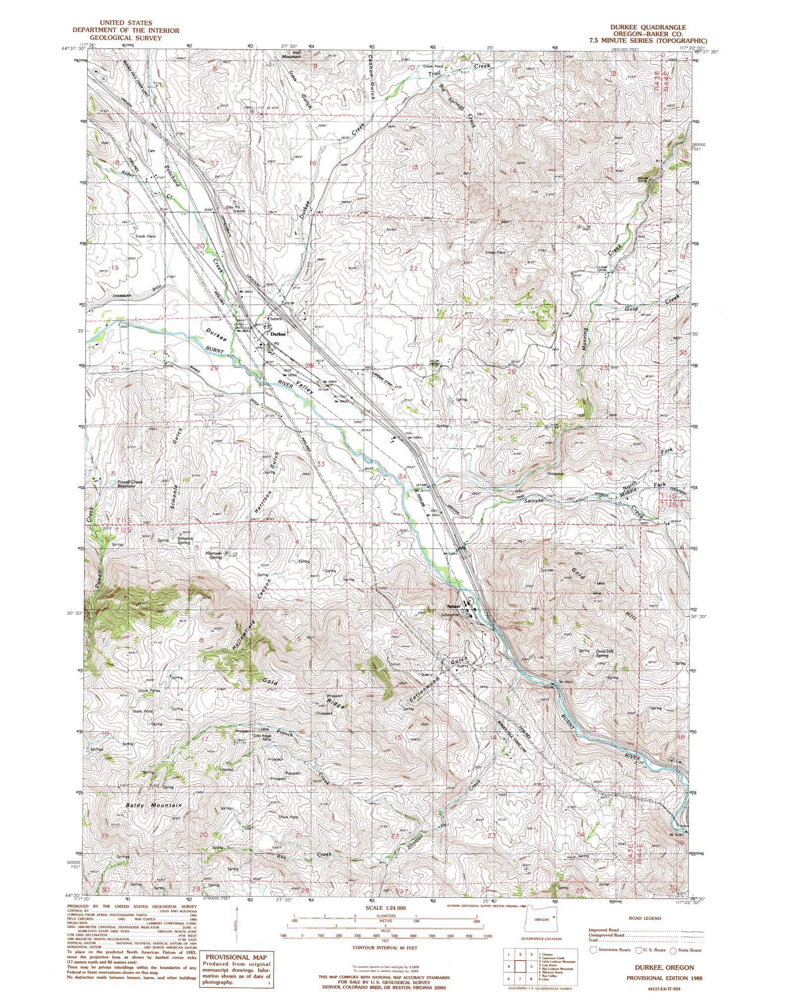
USGS Topo Quad 44117e4 - 1:24,000 scale
| Topo Map Name: | Durkee |
| USGS Topo Quad ID: | 44117e4 |
| Print Size: | ca. 21 1/4" wide x 27" high |
| Southeast Coordinates: | 44.5° N latitude / 117.375° W longitude |
| Map Center Coordinates: | 44.5625° N latitude / 117.4375° W longitude |
| U.S. State: | OR |
| Filename: | o44117e4.jpg |
| Download Map JPG Image: | Durkee topo map 1:24,000 scale |
| Map Type: | Topographic |
| Topo Series: | 7.5´ |
| Map Scale: | 1:24,000 |
| Source of Map Images: | United States Geological Survey (USGS) |
| Alternate Map Versions: |
Durkee OR 1988, updated 1988 Download PDF Buy paper map Durkee OR 2011 Download PDF Buy paper map Durkee OR 2014 Download PDF Buy paper map |
1:24,000 Topo Quads surrounding Durkee
Virtue Flat |
Keating |
Glasgow Butte |
Sparta |
Richland |
Encina |
Oxman |
Lawrence Creek |
Little Lookout Mountain |
Daly Creek |
French Gulch |
Lost Basin |
Durkee |
Big Lookout Mountain |
Connor Creek |
Bridgeport |
Mormon Basin |
Rye Valley |
Lime |
Henley Basin |
Cow Valley East |
Becker Creek |
Birch Creek Meadow |
Huntington |
Olds Ferry |
> Back to 44117e1 at 1:100,000 scale
> Back to 44116a1 at 1:250,000 scale
> Back to U.S. Topo Maps home
Durkee topo map: Gazetteer
Durkee: Canals
Banks Ditch elevation 804m 2637′Durkee: Mines
Gold Ridge Mine elevation 1303m 4274′Durkee: Parks
Rattlesnake Springs Wayside Park (historical) elevation 804m 2637′Durkee: Populated Places
Durkee elevation 808m 2650′Durkee: Post Offices
Durkee Post Office elevation 808m 2650′Plano Post Office (historical) elevation 781m 2562′
Durkee: Reservoirs
Moore Reservoir (historical) elevation 874m 2867′Powell Creek Reservoir elevation 919m 3015′
Durkee: Ridges
Gold Ridge elevation 1464m 4803′Durkee: Springs
Gold Hill Spring elevation 968m 3175′Harrison Spring elevation 962m 3156′
Simonis Spring elevation 994m 3261′
Durkee: Streams
Alder Creek elevation 819m 2687′Big Springs Creek elevation 899m 2949′
Crandall Creek elevation 789m 2588′
Durkee Creek elevation 793m 2601′
French Creek elevation 1020m 3346′
Gold Creek elevation 1018m 3339′
Manning Creek elevation 781m 2562′
Middle Fork Swayze Creek elevation 888m 2913′
North Fork Swayze Creek elevation 874m 2867′
Pritchard Creek elevation 798m 2618′
Ray Creek elevation 1046m 3431′
Shirttail Creek elevation 769m 2522′
Swayze Creek elevation 780m 2559′
Trail Creek elevation 1019m 3343′
Durkee: Summits
Baldy Mountain elevation 1665m 5462′Gold Hill elevation 1247m 4091′
Durkee: Valleys
Buckhorn Gulch elevation 1086m 3562′Cannon Gulch elevation 793m 2601′
Cottonwood Gulch elevation 770m 2526′
Dry Gulch elevation 949m 3113′
Durkee Valley elevation 781m 2562′
Harrison Gulch elevation 844m 2769′
Hollowfield Canyon elevation 978m 3208′
Iron Gulch elevation 867m 2844′
Simonis Gulch elevation 793m 2601′
Durkee digital topo map on disk
Buy this Durkee topo map showing relief, roads, GPS coordinates and other geographical features, as a high-resolution digital map file on DVD: