Bowen Valley Topo Map Oregon
To zoom in, hover over the map of Bowen Valley
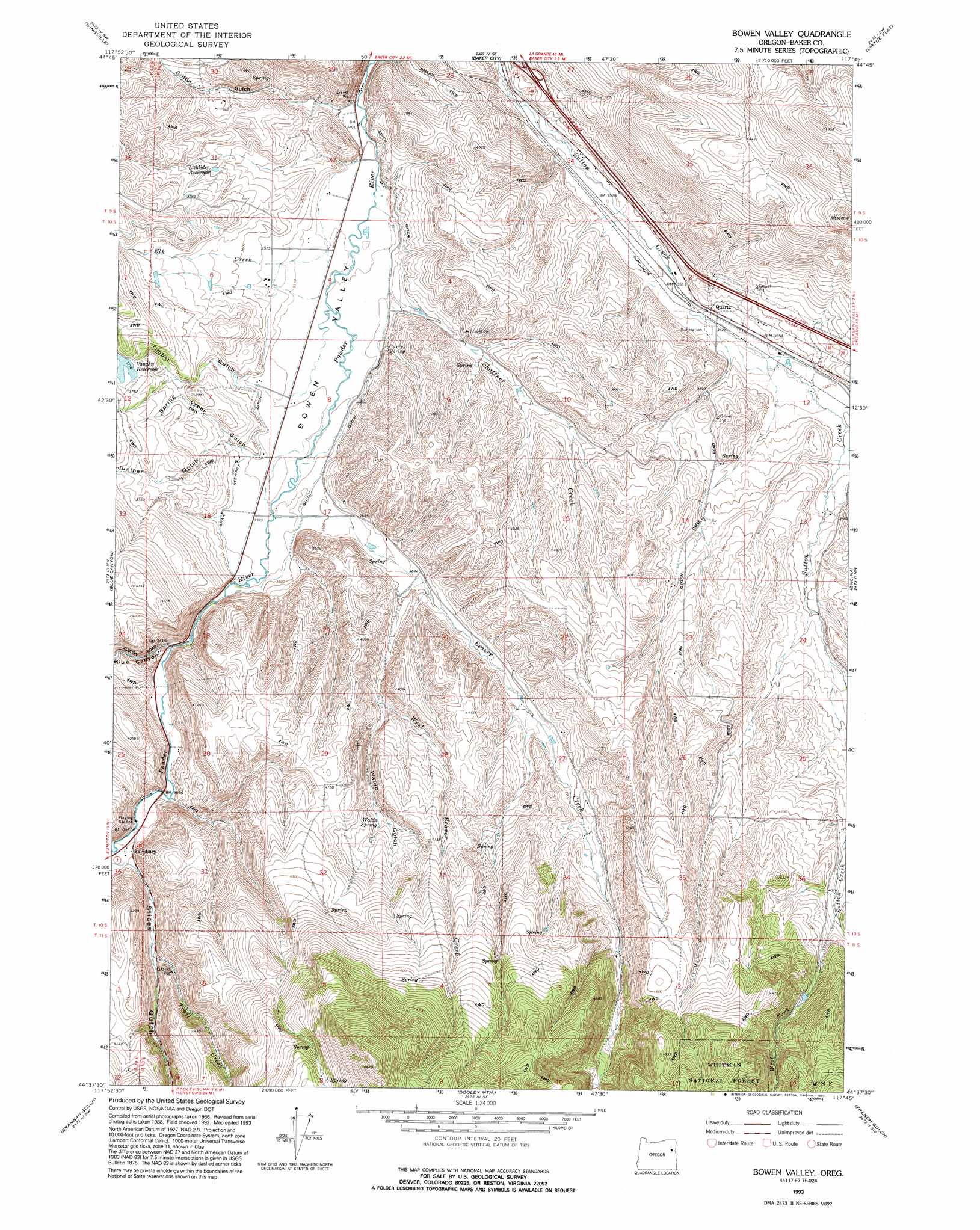
USGS Topo Quad 44117f7 - 1:24,000 scale
| Topo Map Name: | Bowen Valley |
| USGS Topo Quad ID: | 44117f7 |
| Print Size: | ca. 21 1/4" wide x 27" high |
| Southeast Coordinates: | 44.625° N latitude / 117.75° W longitude |
| Map Center Coordinates: | 44.6875° N latitude / 117.8125° W longitude |
| U.S. State: | OR |
| Filename: | o44117f7.jpg |
| Download Map JPG Image: | Bowen Valley topo map 1:24,000 scale |
| Map Type: | Topographic |
| Topo Series: | 7.5´ |
| Map Scale: | 1:24,000 |
| Source of Map Images: | United States Geological Survey (USGS) |
| Alternate Map Versions: |
Bowen Valley OR 1967, updated 1972 Download PDF Buy paper map Bowen Valley OR 1967, updated 1980 Download PDF Buy paper map Bowen Valley OR 1967, updated 1985 Download PDF Buy paper map Bowen Valley OR 1993, updated 1993 Download PDF Buy paper map Bowen Valley OR 2011 Download PDF Buy paper map Bowen Valley OR 2014 Download PDF Buy paper map |
| FStopo: | US Forest Service topo Bowen Valley is available: Download FStopo PDF Download FStopo TIF |
1:24,000 Topo Quads surrounding Bowen Valley
Rock Creek |
Haines |
Magpie Peak |
Keating Nw |
Sawtooth Ridge |
Elkhorn Peak |
Wingville |
Baker |
Virtue Flat |
Keating |
Phillips Lake |
Blue Canyon |
Bowen Valley |
Encina |
Oxman |
Beaverdam Creek |
Brannan Gulch |
Dooley Mountain |
French Gulch |
Lost Basin |
Hereford |
Devils Heel |
Wendt Butte |
Bridgeport |
Mormon Basin |
> Back to 44117e1 at 1:100,000 scale
> Back to 44116a1 at 1:250,000 scale
> Back to U.S. Topo Maps home
Bowen Valley topo map: Gazetteer
Bowen Valley: Canals
Shaw Stewart Ditch elevation 1095m 3592′Smith Ditch elevation 1102m 3615′
Bowen Valley: Dams
Licklider Dam elevation 1122m 3681′Vaughn Dam elevation 1149m 3769′
Bowen Valley: Post Offices
Salisbury Post Office (historical) elevation 1114m 3654′Bowen Valley: Reservoirs
Bennehoff Reservoir elevation 1111m 3645′Licklider Reservoir elevation 1126m 3694′
Nault Reservoir elevation 1267m 4156′
Prowell Reservoir elevation 1273m 4176′
S V Reservoir elevation 1108m 3635′
Vaughn Reservoir elevation 1151m 3776′
Bowen Valley: Springs
Currey Spring elevation 1090m 3576′Waldo Spring elevation 1207m 3959′
Bowen Valley: Streams
Beaver Creek elevation 1094m 3589′Ebell Creek elevation 1127m 3697′
Elk Creek elevation 1076m 3530′
Shaffner Creek elevation 1079m 3540′
Trail Creek elevation 1150m 3772′
West Beaver Creek elevation 1124m 3687′
West Fork Sutton Creek elevation 1272m 4173′
Bowen Valley: Valleys
Belgian Gulch elevation 1159m 3802′Blue Canyon elevation 1099m 3605′
Bowen Valley elevation 1068m 3503′
Griffin Gulch elevation 1068m 3503′
Juniper Gulch elevation 1095m 3592′
Spring Creek Gulch elevation 1091m 3579′
Stices Gulch elevation 1116m 3661′
Timber Gulch elevation 1083m 3553′
Waldo Gulch elevation 1165m 3822′
Bowen Valley digital topo map on disk
Buy this Bowen Valley topo map showing relief, roads, GPS coordinates and other geographical features, as a high-resolution digital map file on DVD: