Blue Canyon Topo Map Oregon
To zoom in, hover over the map of Blue Canyon
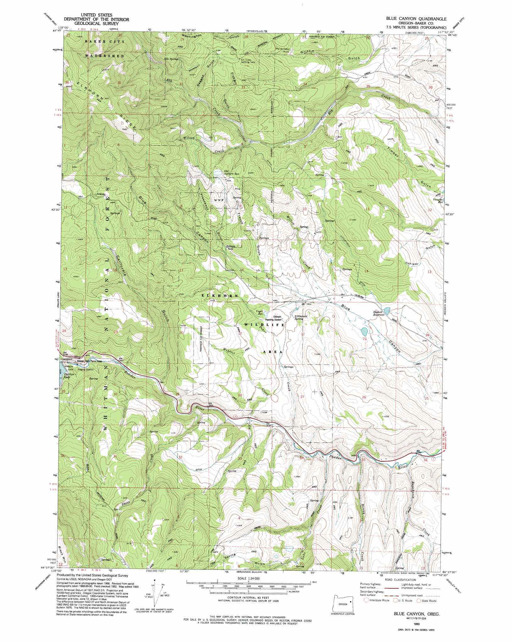
USGS Topo Quad 44117f8 - 1:24,000 scale
| Topo Map Name: | Blue Canyon |
| USGS Topo Quad ID: | 44117f8 |
| Print Size: | ca. 21 1/4" wide x 27" high |
| Southeast Coordinates: | 44.625° N latitude / 117.875° W longitude |
| Map Center Coordinates: | 44.6875° N latitude / 117.9375° W longitude |
| U.S. State: | OR |
| Filename: | o44117f8.jpg |
| Download Map JPG Image: | Blue Canyon topo map 1:24,000 scale |
| Map Type: | Topographic |
| Topo Series: | 7.5´ |
| Map Scale: | 1:24,000 |
| Source of Map Images: | United States Geological Survey (USGS) |
| Alternate Map Versions: |
Blue Canyon OR 1967, updated 1972 Download PDF Buy paper map Blue Canyon OR 1967, updated 1980 Download PDF Buy paper map Blue Canyon OR 1967, updated 1985 Download PDF Buy paper map Blue Canyon OR 1993, updated 1993 Download PDF Buy paper map Blue Canyon OR 2011 Download PDF Buy paper map Blue Canyon OR 2014 Download PDF Buy paper map |
| FStopo: | US Forest Service topo Blue Canyon is available: Download FStopo PDF Download FStopo TIF |
1:24,000 Topo Quads surrounding Blue Canyon
Anthony Lakes |
Rock Creek |
Haines |
Magpie Peak |
Keating Nw |
Bourne |
Elkhorn Peak |
Wingville |
Baker |
Virtue Flat |
Sumpter |
Phillips Lake |
Blue Canyon |
Bowen Valley |
Encina |
Unity Reservoir |
Beaverdam Creek |
Brannan Gulch |
Dooley Mountain |
French Gulch |
Unity |
Hereford |
Devils Heel |
Wendt Butte |
Bridgeport |
> Back to 44117e1 at 1:100,000 scale
> Back to 44116a1 at 1:250,000 scale
> Back to U.S. Topo Maps home
Blue Canyon topo map: Gazetteer
Blue Canyon: Canals
Littlefield Ditch elevation 1314m 4311′Blue Canyon: Dams
Mason Dam elevation 1242m 4074′Blue Canyon: Populated Places
Auburn (historical) elevation 1284m 4212′Blue Canyon: Post Offices
Auburn Post Office (historical) elevation 1284m 4212′Blue Canyon: Reservoirs
Elk Creek Settling Tank elevation 1563m 5127′Haskell Reservoir elevation 1160m 3805′
Miles Pond elevation 1354m 4442′
Old Auburn Reservoir elevation 1506m 4940′
Vogel Reservoir elevation 1226m 4022′
Blue Canyon: Springs
Elk Spring elevation 1610m 5282′Littlefield Spring elevation 1214m 3982′
Blue Canyon: Streams
Denny Creek elevation 1122m 3681′Lake Creek elevation 1130m 3707′
Poker Creek elevation 1138m 3733′
Rancheria Creek elevation 1115m 3658′
Sheep Creek elevation 1147m 3763′
Webfoot Creek elevation 1143m 3750′
Willow Creek elevation 1172m 3845′
Wilson Creek elevation 1351m 4432′
Blue Canyon: Swamps
Salisbury Marsh elevation 1117m 3664′Blue Canyon: Valleys
California Gulch elevation 1174m 3851′Fivebit Gulch elevation 1380m 4527′
Freezeout Gulch elevation 1265m 4150′
French Gulch elevation 1211m 3973′
Ragged Gulch elevation 1445m 4740′
Spring Gulch elevation 1337m 4386′
Washington Gulch elevation 1509m 4950′
Blue Canyon digital topo map on disk
Buy this Blue Canyon topo map showing relief, roads, GPS coordinates and other geographical features, as a high-resolution digital map file on DVD: