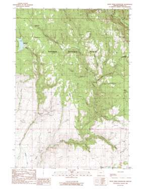
Balm Creek Reservoir Topo Map Oregon
To zoom in, hover over the map of Balm Creek Reservoir
USGS Topo Quad 44117h4 - 1:24,000 scale
| Topo Map Name: | Balm Creek Reservoir |
| USGS Topo Quad ID: | 44117h4 |
| Print Size: | ca. 21 1/4" wide x 27" high |
| Southeast Coordinates: | 44.875° N latitude / 117.375° W longitude |
| Map Center Coordinates: | 44.9375° N latitude / 117.4375° W longitude |
| U.S. State: | OR |
| Filename: | o44117h4.jpg |
| Download Map JPG Image: | Balm Creek Reservoir topo map 1:24,000 scale |
| Map Type: | Topographic |
| Topo Series: | 7.5´ |
| Map Scale: | 1:24,000 |
| Source of Map Images: | United States Geological Survey (USGS) |
| Alternate Map Versions: |
Balm Creek Reservoir OR 1988, updated 1988 Download PDF Buy paper map Balm Creek Reservoir OR 2011 Download PDF Buy paper map Balm Creek Reservoir OR 2014 Download PDF Buy paper map |
| FStopo: | US Forest Service topo Balm Creek Reservoir is available: Download FStopo PDF Download FStopo TIF |
1:24,000 Topo Quads surrounding Balm Creek Reservoir
> Back to 44117e1 at 1:100,000 scale
> Back to 44116a1 at 1:250,000 scale
> Back to U.S. Topo Maps home
Balm Creek Reservoir topo map: Gazetteer
Balm Creek Reservoir: Canals
Phillips Ditch elevation 957m 3139′Balm Creek Reservoir: Dams
Balm Creek Dam elevation 1380m 4527′Balm Creek Reservoir: Flats
Forshey Meadow elevation 1290m 4232′Balm Creek Reservoir: Lakes
Goose Lake elevation 1112m 3648′Balm Creek Reservoir: Mines
Balm Creek Shaft elevation 1058m 3471′Daddy Lode Mine elevation 1216m 3989′
Poorman Mine elevation 1133m 3717′
Sanger Mine elevation 1447m 4747′
Balm Creek Reservoir: Post Offices
Arthur Post Office (historical) elevation 1047m 3435′Sanger Post Office (historical) elevation 1440m 4724′
Balm Creek Reservoir: Reservoirs
Balm Creek Reservoir elevation 1380m 4527′Gover Reservoir elevation 1199m 3933′
Balm Creek Reservoir: Ridges
Red Ridge elevation 1391m 4563′Balm Creek Reservoir: Springs
Surprise Spring elevation 1351m 4432′Union Spring elevation 1459m 4786′
Balm Creek Reservoir: Streams
Bennet Creek elevation 1217m 3992′Bradley Creek elevation 1267m 4156′
Cottonwood Creek elevation 1004m 3293′
Cougar Creek elevation 1272m 4173′
East Fork Goose Creek elevation 1289m 4229′
Forshey Creek elevation 1121m 3677′
Larkspur Creek elevation 1232m 4041′
Ledge Creek elevation 1187m 3894′
O'Brien Creek elevation 1259m 4130′
Rattlesnake Creek elevation 1179m 3868′
Sawmill Creek elevation 1081m 3546′
Sheep Creek elevation 927m 3041′
Slide Creek elevation 1039m 3408′
Sucker Creek elevation 1186m 3891′
West Fork Goose Creek elevation 1231m 4038′
Balm Creek Reservoir: Summits
Red Knob elevation 1550m 5085′Balm Creek Reservoir: Valleys
Dark Canyon elevation 1269m 4163′Lost Gulch elevation 1306m 4284′
Red Gulch elevation 1227m 4025′
Sanger Gulch elevation 1344m 4409′
Balm Creek Reservoir digital topo map on disk
Buy this Balm Creek Reservoir topo map showing relief, roads, GPS coordinates and other geographical features, as a high-resolution digital map file on DVD:


