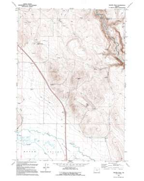
Magpie Peak Topo Map Oregon
To zoom in, hover over the map of Magpie Peak
USGS Topo Quad 44117h7 - 1:24,000 scale
| Topo Map Name: | Magpie Peak |
| USGS Topo Quad ID: | 44117h7 |
| Print Size: | ca. 21 1/4" wide x 27" high |
| Southeast Coordinates: | 44.875° N latitude / 117.75° W longitude |
| Map Center Coordinates: | 44.9375° N latitude / 117.8125° W longitude |
| U.S. State: | OR |
| Filename: | o44117h7.jpg |
| Download Map JPG Image: | Magpie Peak topo map 1:24,000 scale |
| Map Type: | Topographic |
| Topo Series: | 7.5´ |
| Map Scale: | 1:24,000 |
| Source of Map Images: | United States Geological Survey (USGS) |
| Alternate Map Versions: |
Magpie Peak OR 1967, updated 1971 Download PDF Buy paper map Magpie Peak OR 1967, updated 1971 Download PDF Buy paper map Magpie Peak OR 1994, updated 1994 Download PDF Buy paper map Magpie Peak OR 2011 Download PDF Buy paper map Magpie Peak OR 2014 Download PDF Buy paper map |
| FStopo: | US Forest Service topo Magpie Peak is available: Download FStopo PDF Download FStopo TIF |
1:24,000 Topo Quads surrounding Magpie Peak
> Back to 44117e1 at 1:100,000 scale
> Back to 44116a1 at 1:250,000 scale
> Back to U.S. Topo Maps home
Magpie Peak topo map: Gazetteer
Magpie Peak: Canals
Lillard Ditch elevation 1028m 3372′Swinger Ditch elevation 1038m 3405′
Magpie Peak: Dams
Colton Dam elevation 1016m 3333′Magpie Peak: Ranges
Farley Hills elevation 1226m 4022′Magpie Peak: Springs
Foley Spring elevation 1088m 3569′Sparta Spring (historical) elevation 1017m 3336′
Magpie Peak: Streams
Magpie Creek elevation 896m 2939′Magpie Peak: Summits
Magpie Peak elevation 1392m 4566′Magpie Peak digital topo map on disk
Buy this Magpie Peak topo map showing relief, roads, GPS coordinates and other geographical features, as a high-resolution digital map file on DVD:


