Jumpoff Joe Mountain Topo Map Oregon
To zoom in, hover over the map of Jumpoff Joe Mountain
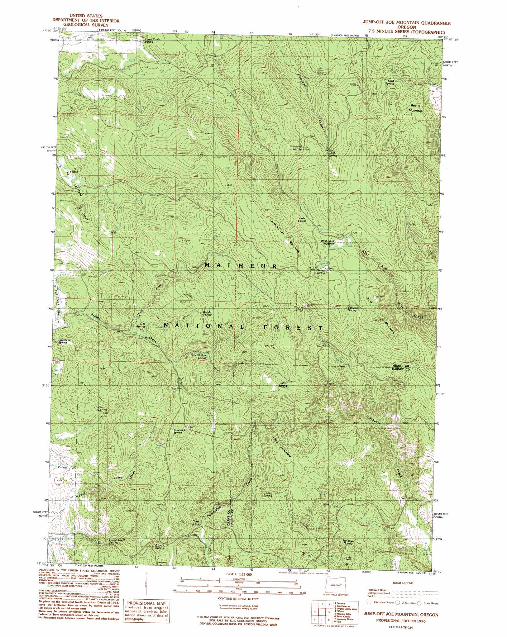
USGS Topo Quad 44118a7 - 1:24,000 scale
| Topo Map Name: | Jumpoff Joe Mountain |
| USGS Topo Quad ID: | 44118a7 |
| Print Size: | ca. 21 1/4" wide x 27" high |
| Southeast Coordinates: | 44° N latitude / 118.75° W longitude |
| Map Center Coordinates: | 44.0625° N latitude / 118.8125° W longitude |
| U.S. State: | OR |
| Filename: | o44118a7.jpg |
| Download Map JPG Image: | Jumpoff Joe Mountain topo map 1:24,000 scale |
| Map Type: | Topographic |
| Topo Series: | 7.5´ |
| Map Scale: | 1:24,000 |
| Source of Map Images: | United States Geological Survey (USGS) |
| Alternate Map Versions: |
Jump-Off Joe Mountain OR 1990, updated 1990 Download PDF Buy paper map Jump-Off Joe Mountain OR 1999, updated 2002 Download PDF Buy paper map Jump-off Joe Mountain OR 2011 Download PDF Buy paper map Jump-off Joe Mountain OR 2014 Download PDF Buy paper map |
| FStopo: | US Forest Service topo Jump-off Joe Mountain is available: Download FStopo PDF Download FStopo TIF |
1:24,000 Topo Quads surrounding Jumpoff Joe Mountain
Fall Mountain |
Canyon Mountain |
Pine Creek Mountain |
Strawberry Mountain |
Roberts Creek |
Scotty Creek |
Seneca |
Big Canyon |
Logan Valley West |
Logan Valley East |
Rail Creek Butte |
Silvies |
Jumpoff Joe Mountain |
Magpie Table |
Dollar Basin |
Myrtle Park Meadows |
Trout Creek |
Calamity Butte |
Van |
Moffit Table |
Mosquito Flat |
Devine Ridge North |
Telephone Butte |
Craft Point |
House Butte |
> Back to 44118a1 at 1:100,000 scale
> Back to 44118a1 at 1:250,000 scale
> Back to U.S. Topo Maps home
Jumpoff Joe Mountain topo map: Gazetteer
Jumpoff Joe Mountain: Flats
Bridge Creek Meadow elevation 1518m 4980′Wolf Creek Meadow elevation 1822m 5977′
Jumpoff Joe Mountain: Springs
Bear Wallow Spring elevation 1674m 5492′Bonde Spring elevation 1785m 5856′
Carson Spring elevation 1799m 5902′
Che Spring elevation 1600m 5249′
Cold Spring elevation 1767m 5797′
Cove Spring elevation 1533m 5029′
Davidson Spring elevation 1572m 5157′
Dry Spring elevation 1578m 5177′
Ewing Spring elevation 1866m 6122′
HCB Spring elevation 1633m 5357′
Holdout Spring elevation 1514m 4967′
House Creek Spring elevation 1575m 5167′
John S Spring elevation 1558m 5111′
Kent Spring elevation 1616m 5301′
Kirkwood Spring elevation 1779m 5836′
Long Spring elevation 1728m 5669′
Milk Spring elevation 1833m 6013′
Mullen Spring elevation 1674m 5492′
Pole Spring elevation 1831m 6007′
S B Spring elevation 1591m 5219′
Schurtz Spring elevation 1868m 6128′
Short Spring elevation 1746m 5728′
Tamarack Spring elevation 1656m 5433′
Three Cabin Spring elevation 1525m 5003′
Willow Spring elevation 1671m 5482′
Jumpoff Joe Mountain: Streams
West Fork Bridge Creek elevation 1555m 5101′Jumpoff Joe Mountain: Summits
Jump-off Joe Mountain elevation 1985m 6512′Long Mountain elevation 1817m 5961′
Round Mountain elevation 1710m 5610′
Wolf Mountain elevation 1943m 6374′
Jumpoff Joe Mountain digital topo map on disk
Buy this Jumpoff Joe Mountain topo map showing relief, roads, GPS coordinates and other geographical features, as a high-resolution digital map file on DVD: