Silvies Topo Map Oregon
To zoom in, hover over the map of Silvies
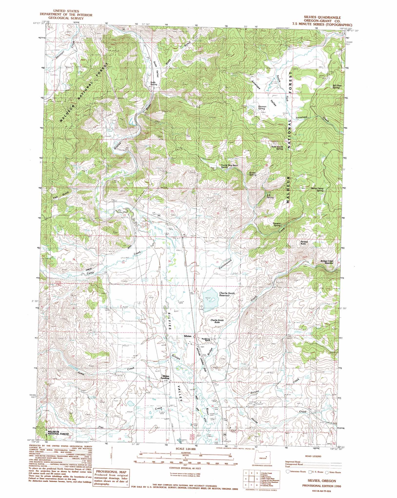
USGS Topo Quad 44118a8 - 1:24,000 scale
| Topo Map Name: | Silvies |
| USGS Topo Quad ID: | 44118a8 |
| Print Size: | ca. 21 1/4" wide x 27" high |
| Southeast Coordinates: | 44° N latitude / 118.875° W longitude |
| Map Center Coordinates: | 44.0625° N latitude / 118.9375° W longitude |
| U.S. State: | OR |
| Filename: | o44118a8.jpg |
| Download Map JPG Image: | Silvies topo map 1:24,000 scale |
| Map Type: | Topographic |
| Topo Series: | 7.5´ |
| Map Scale: | 1:24,000 |
| Source of Map Images: | United States Geological Survey (USGS) |
| Alternate Map Versions: |
Silvies OR 1990, updated 1990 Download PDF Buy paper map Silvies OR 1999, updated 2002 Download PDF Buy paper map Silvies OR 2011 Download PDF Buy paper map Silvies OR 2014 Download PDF Buy paper map |
| FStopo: | US Forest Service topo Silvies is available: Download FStopo PDF Download FStopo TIF |
1:24,000 Topo Quads surrounding Silvies
Mcclellan Mountain |
Fall Mountain |
Canyon Mountain |
Pine Creek Mountain |
Strawberry Mountain |
Logdell |
Scotty Creek |
Seneca |
Big Canyon |
Logan Valley West |
Five Hundred Flat |
Rail Creek Butte |
Silvies |
Jumpoff Joe Mountain |
Magpie Table |
West Myrtle Butte |
Myrtle Park Meadows |
Trout Creek |
Calamity Butte |
Van |
Landing Creek |
Mosquito Flat |
Devine Ridge North |
Telephone Butte |
Craft Point |
> Back to 44118a1 at 1:100,000 scale
> Back to 44118a1 at 1:250,000 scale
> Back to U.S. Topo Maps home
Silvies topo map: Gazetteer
Silvies: Airports
Maitland Landing Strip elevation 1395m 4576′Silvies: Canals
Owens Ditch elevation 1417m 4648′Silvies: Dams
Bennett Dam elevation 1439m 4721′Lake Pons Dam elevation 1405m 4609′
Silvies: Populated Places
Silvies elevation 1402m 4599′Silvies: Post Offices
Rann Post Office (historical) elevation 1395m 4576′Silvies Post Office (historical) elevation 1402m 4599′
Silvies: Reservoirs
Charlie Smith Reservoir elevation 1405m 4609′Lake Pons elevation 1405m 4609′
Silvies: Springs
Bill Pete Spring elevation 1526m 5006′Funny Bug Basin Spring elevation 1570m 5150′
Herman Spring elevation 1514m 4967′
S S Spring elevation 1526m 5006′
Scotty Spring elevation 1533m 5029′
Soda Smith Spring elevation 1585m 5200′
Soda Spring elevation 1417m 4648′
Stevens Spring elevation 1505m 4937′
Thirty-Thirty Spring elevation 1564m 5131′
Silvies: Streams
Bridge Creek elevation 1390m 4560′Camp Creek elevation 1398m 4586′
Cottonwood Creek elevation 1403m 4603′
Flat Creek elevation 1390m 4560′
House Creek elevation 1390m 4560′
Jack Andy Creek elevation 1439m 4721′
Jump Creek elevation 1390m 4560′
Poison Creek elevation 1398m 4586′
Silvies: Summits
Charlie Smith Butte elevation 1437m 4714′Parasol Butte elevation 1647m 5403′
Silvies: Valleys
Antelope Valley elevation 1483m 4865′Fisk Gulch elevation 1411m 4629′
Soda Gulch elevation 1426m 4678′
Soda Valley elevation 1428m 4685′
Silvies digital topo map on disk
Buy this Silvies topo map showing relief, roads, GPS coordinates and other geographical features, as a high-resolution digital map file on DVD: