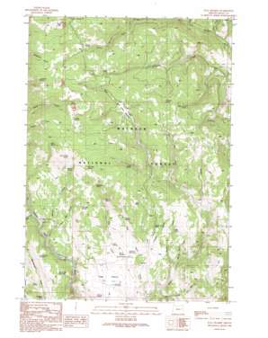
Flag Prairie Topo Map Oregon
To zoom in, hover over the map of Flag Prairie
USGS Topo Quad 44118b3 - 1:24,000 scale
| Topo Map Name: | Flag Prairie |
| USGS Topo Quad ID: | 44118b3 |
| Print Size: | ca. 21 1/4" wide x 27" high |
| Southeast Coordinates: | 44.125° N latitude / 118.25° W longitude |
| Map Center Coordinates: | 44.1875° N latitude / 118.3125° W longitude |
| U.S. State: | OR |
| Filename: | o44118b3.jpg |
| Download Map JPG Image: | Flag Prairie topo map 1:24,000 scale |
| Map Type: | Topographic |
| Topo Series: | 7.5´ |
| Map Scale: | 1:24,000 |
| Source of Map Images: | United States Geological Survey (USGS) |
| Alternate Map Versions: |
Flag Prairie OR 1990, updated 1991 Download PDF Buy paper map Flag Prairie OR 1999, updated 2002 Download PDF Buy paper map Flag Prairie OR 2011 Download PDF Buy paper map Flag Prairie OR 2014 Download PDF Buy paper map |
| FStopo: | US Forest Service topo Flag Prairie is available: Download FStopo PDF Download FStopo TIF |
1:24,000 Topo Quads surrounding Flag Prairie
> Back to 44118a1 at 1:100,000 scale
> Back to 44118a1 at 1:250,000 scale
> Back to U.S. Topo Maps home
Flag Prairie topo map: Gazetteer
Flag Prairie: Flats
Bear Creek Meadow elevation 1643m 5390′Flag Prairie elevation 1434m 4704′
Lost Dog Flat elevation 1488m 4881′
Flag Prairie: Reservoirs
Burned Tree Reservoir elevation 1496m 4908′Dutch Oven Reservoir elevation 1467m 4812′
JB Reservoir elevation 1437m 4714′
Lost Dog Reservoir elevation 1467m 4812′
Mud Flat Reservoir elevation 1448m 4750′
WPA Reservoir elevation 1456m 4776′
Flag Prairie: Ridges
Rattlesnake Ridge elevation 1610m 5282′Flag Prairie: Springs
Alarm Clock Spring elevation 1667m 5469′Aspen Spring elevation 1551m 5088′
Buck Spring elevation 1728m 5669′
Canteeno Spring elevation 1704m 5590′
Cold Spring elevation 1637m 5370′
ERA Spring elevation 1464m 4803′
Gib Spring elevation 1555m 5101′
Horseshoe Spring elevation 1720m 5643′
Hunter Spring elevation 1656m 5433′
Kate Spring elevation 1609m 5278′
Lava Spring elevation 1717m 5633′
Lightning Spring elevation 1538m 5045′
McKenzie Spring elevation 1658m 5439′
Pine Tree Spring elevation 1721m 5646′
Red Hill Spring elevation 1600m 5249′
Root Spring elevation 1668m 5472′
Sage Hen Spring elevation 1600m 5249′
Schlupe Spring elevation 1468m 4816′
Seven D Bar Spring elevation 1713m 5620′
Station Spring elevation 1627m 5337′
Tamarack Spring elevation 1747m 5731′
Tub Spring elevation 1735m 5692′
Turner Spring elevation 1508m 4947′
Willow Spring elevation 1554m 5098′
Flag Prairie: Streams
Aspen Creek elevation 1438m 4717′Camp Creek elevation 1460m 4790′
Canteen Creek elevation 1487m 4878′
Crane Creek elevation 1375m 4511′
Hunter Creek elevation 1610m 5282′
Kate Creek elevation 1386m 4547′
Monkey Run elevation 1456m 4776′
Raw Dog Creek elevation 1569m 5147′
Station Creek elevation 1390m 4560′
Flag Prairie: Summits
Bingham Point elevation 1643m 5390′Prairie Hill elevation 1801m 5908′
Flag Prairie: Valleys
Lost Dog Gulch elevation 1473m 4832′Sagehen Gulch elevation 1389m 4557′
Sheep Gulch elevation 1541m 5055′
Tongue Gulch elevation 1475m 4839′
Flag Prairie digital topo map on disk
Buy this Flag Prairie topo map showing relief, roads, GPS coordinates and other geographical features, as a high-resolution digital map file on DVD:


