Big Canyon Topo Map Oregon
To zoom in, hover over the map of Big Canyon
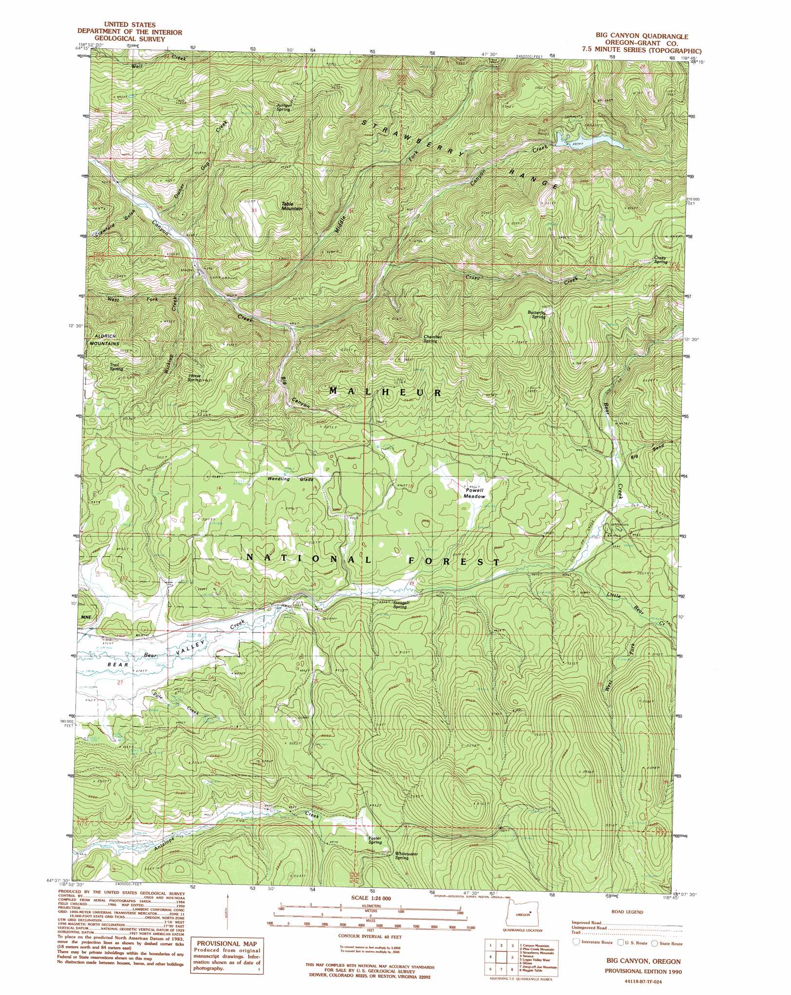
USGS Topo Quad 44118b7 - 1:24,000 scale
| Topo Map Name: | Big Canyon |
| USGS Topo Quad ID: | 44118b7 |
| Print Size: | ca. 21 1/4" wide x 27" high |
| Southeast Coordinates: | 44.125° N latitude / 118.75° W longitude |
| Map Center Coordinates: | 44.1875° N latitude / 118.8125° W longitude |
| U.S. State: | OR |
| Filename: | o44118b7.jpg |
| Download Map JPG Image: | Big Canyon topo map 1:24,000 scale |
| Map Type: | Topographic |
| Topo Series: | 7.5´ |
| Map Scale: | 1:24,000 |
| Source of Map Images: | United States Geological Survey (USGS) |
| Alternate Map Versions: |
Big Canyon OR 1990, updated 1990 Download PDF Buy paper map Big Canyon OR 1998, updated 2000 Download PDF Buy paper map Big Canyon OR 2011 Download PDF Buy paper map Big Canyon OR 2014 Download PDF Buy paper map |
| FStopo: | US Forest Service topo Big Canyon is available: Download FStopo PDF Download FStopo TIF |
1:24,000 Topo Quads surrounding Big Canyon
Mount Vernon |
John Day |
Castle Creek |
Prairie City |
Isham Creek |
Fall Mountain |
Canyon Mountain |
Pine Creek Mountain |
Strawberry Mountain |
Roberts Creek |
Scotty Creek |
Seneca |
Big Canyon |
Logan Valley West |
Logan Valley East |
Rail Creek Butte |
Silvies |
Jumpoff Joe Mountain |
Magpie Table |
Dollar Basin |
Myrtle Park Meadows |
Trout Creek |
Calamity Butte |
Van |
Moffit Table |
> Back to 44118a1 at 1:100,000 scale
> Back to 44118a1 at 1:250,000 scale
> Back to U.S. Topo Maps home
Big Canyon topo map: Gazetteer
Big Canyon: Canals
Byron Ditch elevation 1451m 4760′Big Canyon: Dams
Canyon Creek Meadows Dam elevation 1538m 5045′Big Canyon: Flats
Canyon Creek Meadow elevation 1537m 5042′Powell Meadow elevation 1500m 4921′
Wendling Glade elevation 1520m 4986′
Big Canyon: Lakes
Canyon Meadows Lake elevation 1538m 5045′Big Canyon: Springs
Betum Spring elevation 1305m 4281′Butterfly Spring elevation 1711m 5613′
Chamber Spring elevation 1660m 5446′
Crazy Spring elevation 1731m 5679′
Foster Spring elevation 1519m 4983′
Horse Spring elevation 1561m 5121′
Juniper Spring elevation 1620m 5314′
Little Rock Spring elevation 1480m 4855′
Rock Spring elevation 1515m 4970′
Steagall Spring elevation 1482m 4862′
Trail Spring elevation 1543m 5062′
Whitewater Spring elevation 1540m 5052′
Big Canyon: Streams
Crazy Creek elevation 1386m 4547′Little Bear Creek elevation 1492m 4895′
Lower Gap Creek elevation 1289m 4229′
Middle Fork Canyon Creek elevation 1318m 4324′
Pole Creek elevation 1453m 4767′
West Fork Little Bear Creek elevation 1510m 4954′
West Fork Wickiup Creek elevation 1359m 4458′
Wickiup Creek elevation 1341m 4399′
Big Canyon: Summits
Table Mountain elevation 1595m 5232′Big Canyon: Valleys
Big Bend elevation 1519m 4983′Big Canyon elevation 1357m 4452′
Crawford Gulch elevation 1289m 4229′
Big Canyon digital topo map on disk
Buy this Big Canyon topo map showing relief, roads, GPS coordinates and other geographical features, as a high-resolution digital map file on DVD: