Roberts Creek Topo Map Oregon
To zoom in, hover over the map of Roberts Creek
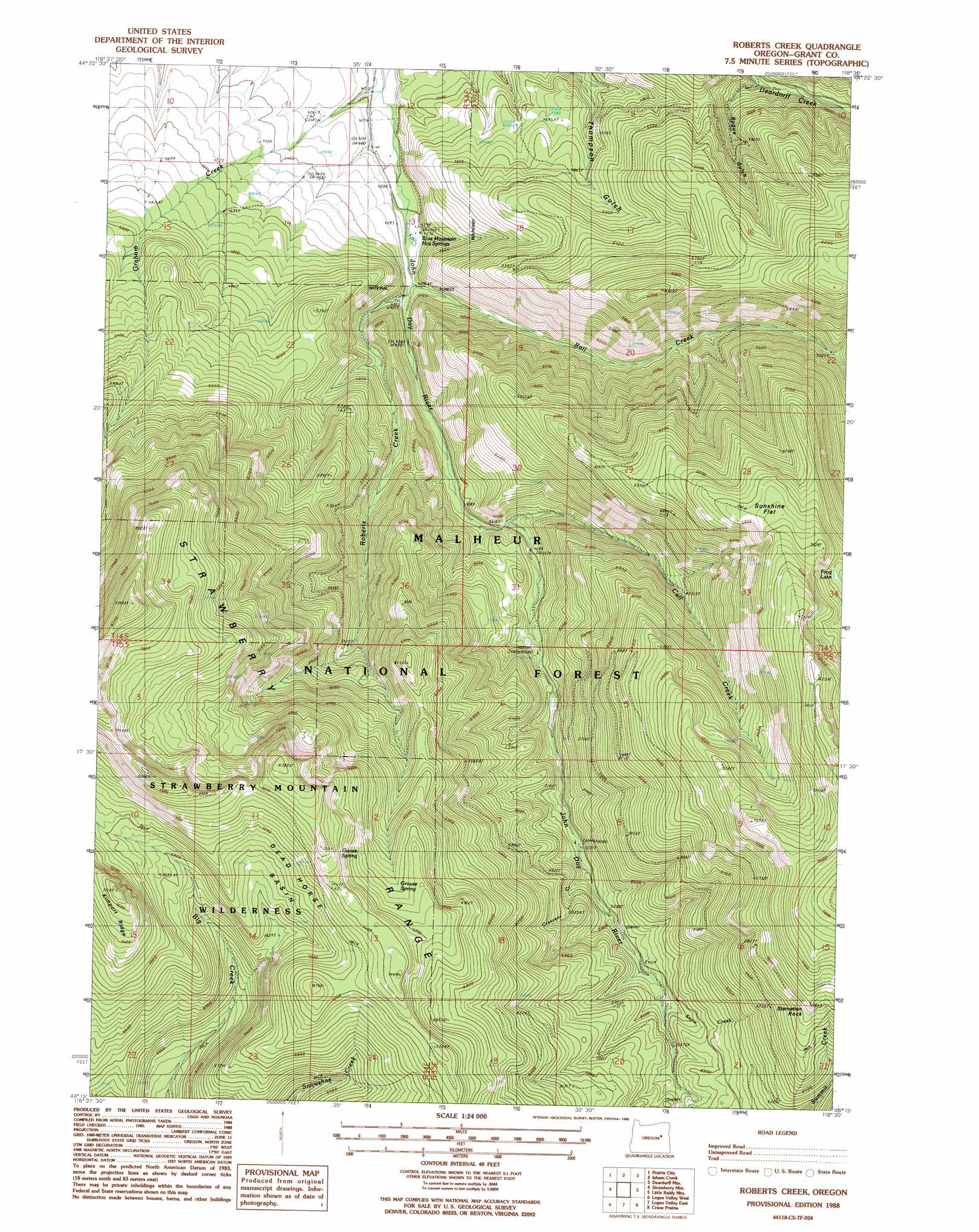
USGS Topo Quad 44118c5 - 1:24,000 scale
| Topo Map Name: | Roberts Creek |
| USGS Topo Quad ID: | 44118c5 |
| Print Size: | ca. 21 1/4" wide x 27" high |
| Southeast Coordinates: | 44.25° N latitude / 118.5° W longitude |
| Map Center Coordinates: | 44.3125° N latitude / 118.5625° W longitude |
| U.S. State: | OR |
| Filename: | o44118c5.jpg |
| Download Map JPG Image: | Roberts Creek topo map 1:24,000 scale |
| Map Type: | Topographic |
| Topo Series: | 7.5´ |
| Map Scale: | 1:24,000 |
| Source of Map Images: | United States Geological Survey (USGS) |
| Alternate Map Versions: |
Roberts Creek OR 1988, updated 1988 Download PDF Buy paper map Roberts Creek OR 1996, updated 1998 Download PDF Buy paper map Roberts Creek OR 2011 Download PDF Buy paper map Roberts Creek OR 2014 Download PDF Buy paper map |
| FStopo: | US Forest Service topo Roberts Creek is available: Download FStopo PDF Download FStopo TIF |
1:24,000 Topo Quads surrounding Roberts Creek
Cougar Rock |
Dixie Meadows |
Bates |
Austin |
Pogue Point |
Castle Creek |
Prairie City |
Isham Creek |
Deardorff Mountain |
Rail Gulch |
Pine Creek Mountain |
Strawberry Mountain |
Roberts Creek |
Little Baldy Mountain |
Bullrun Rock |
Big Canyon |
Logan Valley West |
Logan Valley East |
Crane Prairie |
Flag Prairie |
Jumpoff Joe Mountain |
Magpie Table |
Dollar Basin |
Knox Mountain |
Buck Trough Spring |
> Back to 44118a1 at 1:100,000 scale
> Back to 44118a1 at 1:250,000 scale
> Back to U.S. Topo Maps home
Roberts Creek topo map: Gazetteer
Roberts Creek: Basins
Dead Horse Basin elevation 2037m 6683′Roberts Creek: Flats
Little Meadows elevation 1480m 4855′Sunshine Flat elevation 2087m 6847′
Roberts Creek: Lakes
Frog Lake elevation 2064m 6771′Roberts Creek: Pillars
Starvation Rock elevation 2129m 6984′Roberts Creek: Post Offices
Margaret Post Office (historical) elevation 1289m 4229′Roberts Creek: Ranges
Strawberry Range elevation 1669m 5475′Roberts Creek: Reservoirs
Stanbro Reservoir elevation 1349m 4425′Roberts Creek: Ridges
Kimport Ridge elevation 2348m 7703′Roberts Creek: Springs
Blue Mountain Hot Springs elevation 1303m 4274′Goose Spring elevation 2157m 7076′
Grouse Spring elevation 2129m 6984′
Trout Farm Spring elevation 1504m 4934′
Roberts Creek: Streams
Black Mountain Creek elevation 1389m 4557′Call Creek elevation 1407m 4616′
Crescent Creek elevation 1591m 5219′
Graham Creek elevation 1259m 4130′
Rail Creek elevation 1313m 4307′
Roberts Creek elevation 1320m 4330′
Snow Creek elevation 1683m 5521′
Roberts Creek: Trails
Big Creek Trail elevation 2066m 6778′Grouse Spring Trail (historical) elevation 1996m 6548′
Rail Creek Trail elevation 1957m 6420′
Roberts Creek Trail (historical) elevation 1983m 6505′
Skyline Trail elevation 2272m 7454′
Snowshoe Creek Trail elevation 2151m 7057′
Roberts Creek: Valleys
Bogue Gulch elevation 1387m 4550′Roberts Creek digital topo map on disk
Buy this Roberts Creek topo map showing relief, roads, GPS coordinates and other geographical features, as a high-resolution digital map file on DVD: