Dixie Meadows Topo Map Oregon
To zoom in, hover over the map of Dixie Meadows
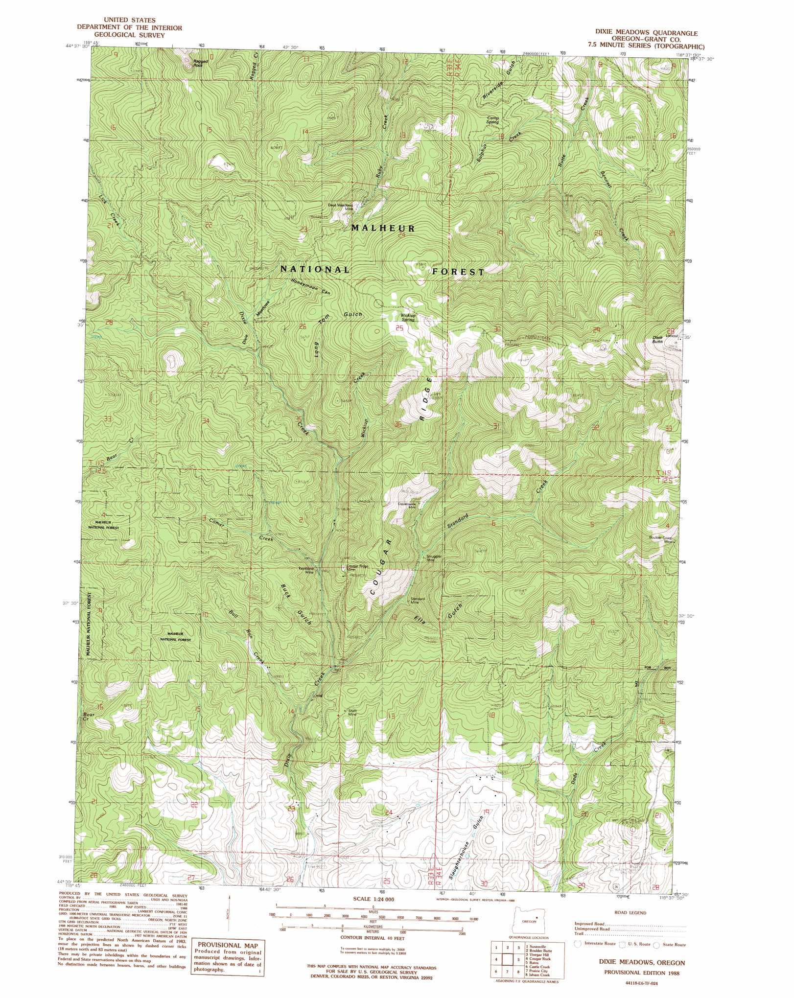
USGS Topo Quad 44118e6 - 1:24,000 scale
| Topo Map Name: | Dixie Meadows |
| USGS Topo Quad ID: | 44118e6 |
| Print Size: | ca. 21 1/4" wide x 27" high |
| Southeast Coordinates: | 44.5° N latitude / 118.625° W longitude |
| Map Center Coordinates: | 44.5625° N latitude / 118.6875° W longitude |
| U.S. State: | OR |
| Filename: | o44118e6.jpg |
| Download Map JPG Image: | Dixie Meadows topo map 1:24,000 scale |
| Map Type: | Topographic |
| Topo Series: | 7.5´ |
| Map Scale: | 1:24,000 |
| Source of Map Images: | United States Geological Survey (USGS) |
| Alternate Map Versions: |
Dixie Meadows OR 1988, updated 1988 Download PDF Buy paper map Dixie Meadows OR 1996, updated 1998 Download PDF Buy paper map Dixie Meadows OR 2011 Download PDF Buy paper map Dixie Meadows OR 2014 Download PDF Buy paper map |
| FStopo: | US Forest Service topo Dixie Meadows is available: Download FStopo PDF Download FStopo TIF |
1:24,000 Topo Quads surrounding Dixie Meadows
Wildcat Point |
Sharp Ridge |
Desolation Butte |
Olive Lake |
Granite |
Keeney Point |
Susanville |
Boulder Butte |
Vinegar Hill |
Greenhorn |
Magone Lake |
Cougar Rock |
Dixie Meadows |
Bates |
Austin |
John Day |
Castle Creek |
Prairie City |
Isham Creek |
Deardorff Mountain |
Canyon Mountain |
Pine Creek Mountain |
Strawberry Mountain |
Roberts Creek |
Little Baldy Mountain |
> Back to 44118e1 at 1:100,000 scale
> Back to 44118a1 at 1:250,000 scale
> Back to U.S. Topo Maps home
Dixie Meadows topo map: Gazetteer
Dixie Meadows: Flats
Dixie Meadows elevation 1544m 5065′Dixie Meadows: Mines
Boulder Group Mine elevation 1781m 5843′Copperopolis Mine elevation 1485m 4872′
Cougar Ridge Mine elevation 1593m 5226′
Dixie Meadows Mine elevation 1611m 5285′
Keystone Mine elevation 1435m 4708′
Shatt Mine elevation 1425m 4675′
Smuggler Mine elevation 1415m 4642′
Standard Mine elevation 1400m 4593′
Dixie Meadows: Post Offices
Comer Post Office (historical) elevation 1316m 4317′Dixie Meadows: Springs
Camp Spring elevation 1460m 4790′Wickiup Spring elevation 1920m 6299′
Dixie Meadows: Streams
Bennett Creek elevation 1274m 4179′Bull Run Creek elevation 1291m 4235′
Comer Creek elevation 1410m 4625′
Standard Creek elevation 1314m 4311′
Sulphur Creek elevation 1307m 4288′
Wickiup Creek elevation 1450m 4757′
Dixie Meadows: Summits
Dixie Butte elevation 2304m 7559′Ragged Rocks elevation 1911m 6269′
Dixie Meadows: Trails
Lick Creek Trail (historical) elevation 1559m 5114′Ragged Rocks Trail (historical) elevation 1886m 6187′
Dixie Meadows: Valleys
Buck Gulch elevation 1414m 4639′Ella Gulch elevation 1772m 5813′
Honeymoon Canyon elevation 1574m 5164′
Long Tom Gulch elevation 1487m 4878′
Dixie Meadows digital topo map on disk
Buy this Dixie Meadows topo map showing relief, roads, GPS coordinates and other geographical features, as a high-resolution digital map file on DVD: