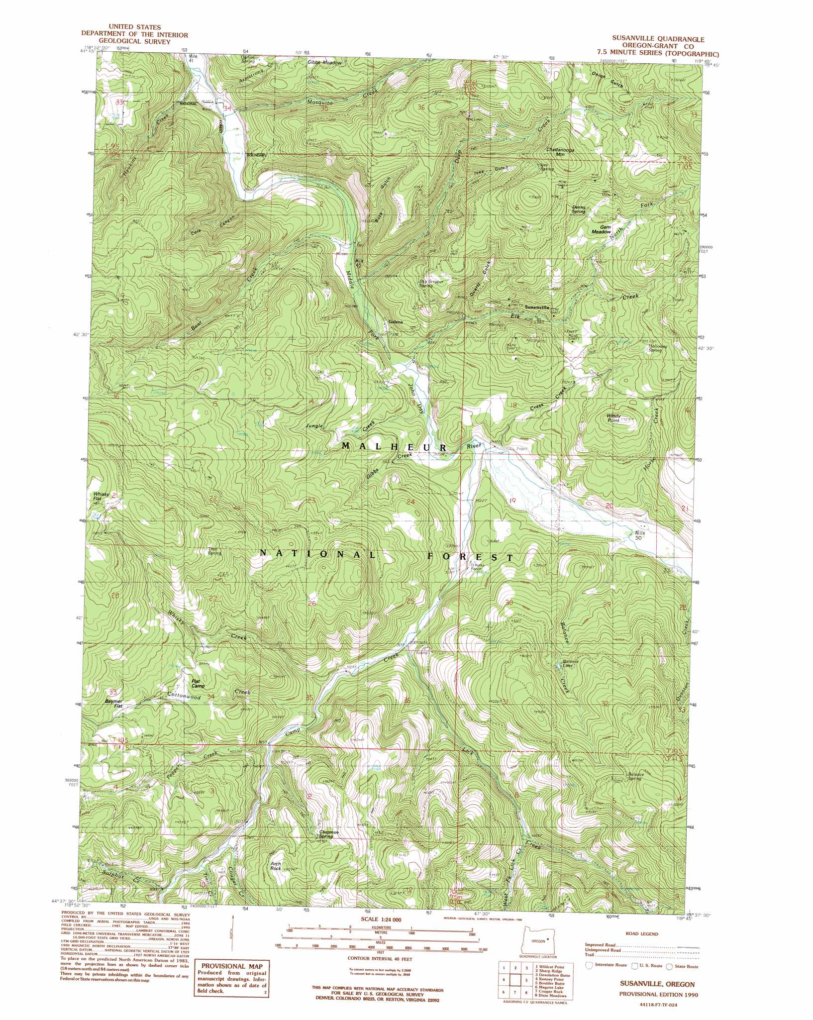
Susanville Topo Map Oregon
To zoom in, hover over the map of Susanville
USGS Topo Quad 44118f7 - 1:24,000 scale
| Topo Map Name: | Susanville |
| USGS Topo Quad ID: | 44118f7 |
| Print Size: | ca. 21 1/4" wide x 27" high |
| Southeast Coordinates: | 44.625° N latitude / 118.75° W longitude |
| Map Center Coordinates: | 44.6875° N latitude / 118.8125° W longitude |
| U.S. State: | OR |
| Filename: | o44118f7.jpg |
| Download Map JPG Image: | Susanville topo map 1:24,000 scale |
| Map Type: | Topographic |
| Topo Series: | 7.5´ |
| Map Scale: | 1:24,000 |
| Source of Map Images: | United States Geological Survey (USGS) |
| Alternate Map Versions: |
Susanville OR 1990, updated 1990 Download PDF Buy paper map Susanville OR 1999, updated 2002 Download PDF Buy paper map Susanville OR 2011 Download PDF Buy paper map Susanville OR 2014 Download PDF Buy paper map |
| FStopo: | US Forest Service topo Susanville is available: Download FStopo PDF Download FStopo TIF |
1:24,000 Topo Quads surrounding Susanville
Meadow Brook Summit |
Dale |
The Cockscomb |
Kelsay Butte |
Silver Butte |
Flowers Gulch |
Wildcat Point |
Sharp Ridge |
Desolation Butte |
Olive Lake |
Long Creek |
Keeney Point |
Susanville |
Boulder Butte |
Vinegar Hill |
Beech Creek Summit |
Magone Lake |
Cougar Rock |
Dixie Meadows |
Bates |
Mount Vernon |
John Day |
Castle Creek |
Prairie City |
Isham Creek |
> Back to 44118e1 at 1:100,000 scale
> Back to 44118a1 at 1:250,000 scale
> Back to U.S. Topo Maps home
Susanville topo map: Gazetteer
Susanville: Flats
Beymer Flat elevation 1391m 4563′Gem Meadows elevation 1319m 4327′
Gibbs Meadow elevation 1220m 4002′
Susanville: Lakes
Balance Lake elevation 1302m 4271′Susanville: Mines
Gem Mine elevation 1412m 4632′Susanville: Pillars
Arch Rock elevation 1393m 4570′Susanville: Populated Places
Galena elevation 1040m 3412′Susanville elevation 1173m 3848′
Susanville: Post Offices
Galena Post Office (historical) elevation 1040m 3412′Susanville Post Office (historical) elevation 1173m 3848′
Susanville: Springs
Balance Spring elevation 1532m 5026′Chapman Spring elevation 1331m 4366′
Denny Spring elevation 1397m 4583′
Holloway Spring elevation 1300m 4265′
Ives Spring elevation 1453m 4767′
Ogilvie Spring elevation 1173m 3848′
Sky Scraper Spring elevation 1255m 4117′
Trail Spring elevation 1523m 4996′
Susanville: Streams
Armstrong Creek elevation 1014m 3326′Balance Creek elevation 1067m 3500′
Bear Creek elevation 1037m 3402′
Camp Creek elevation 1058m 3471′
Cottonwood Creek elevation 1156m 3792′
Cougar Creek elevation 1211m 3973′
Cress Creek elevation 1061m 3480′
Deep Creek elevation 1038m 3405′
Dunston Creek elevation 1094m 3589′
Elk Creek elevation 1043m 3421′
Gibbs Creek elevation 1050m 3444′
Hawkins Creek elevation 1013m 3323′
Horse Creek elevation 1067m 3500′
Jungle Creek elevation 1049m 3441′
Lick Creek elevation 1116m 3661′
Mosquito Creek elevation 1017m 3336′
North Fork Elk Creek elevation 1214m 3982′
Pepper Creek elevation 1188m 3897′
Sulphur Creek elevation 1241m 4071′
Trail Creek elevation 1225m 4019′
West Fork Lick Creek elevation 1235m 4051′
Whisky Creek elevation 1144m 3753′
Susanville: Summits
Chattanooga Mountain elevation 1547m 5075′Crockett Knob elevation 1447m 4747′
Windy Point elevation 1323m 4340′
Susanville: Valleys
Buck Gulch elevation 1035m 3395′Cole Canyon elevation 1037m 3402′
Ives Gulch elevation 1172m 3845′
Quartz Gulch elevation 1108m 3635′
Susanville digital topo map on disk
Buy this Susanville topo map showing relief, roads, GPS coordinates and other geographical features, as a high-resolution digital map file on DVD: