Desolation Butte Topo Map Oregon
To zoom in, hover over the map of Desolation Butte
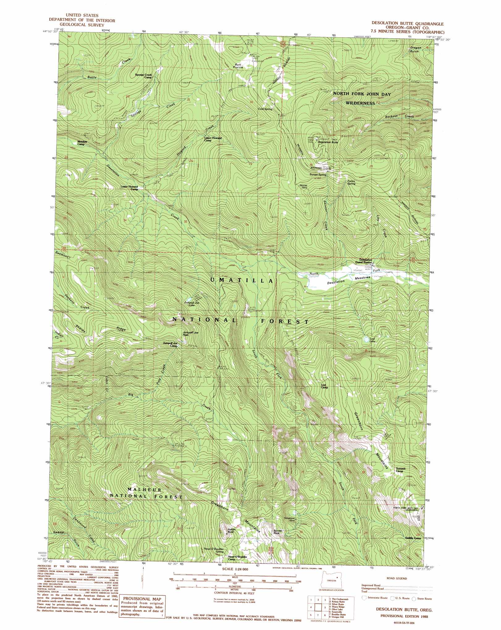
USGS Topo Quad 44118g6 - 1:24,000 scale
| Topo Map Name: | Desolation Butte |
| USGS Topo Quad ID: | 44118g6 |
| Print Size: | ca. 21 1/4" wide x 27" high |
| Southeast Coordinates: | 44.75° N latitude / 118.625° W longitude |
| Map Center Coordinates: | 44.8125° N latitude / 118.6875° W longitude |
| U.S. State: | OR |
| Filename: | o44118g6.jpg |
| Download Map JPG Image: | Desolation Butte topo map 1:24,000 scale |
| Map Type: | Topographic |
| Topo Series: | 7.5´ |
| Map Scale: | 1:24,000 |
| Source of Map Images: | United States Geological Survey (USGS) |
| Alternate Map Versions: |
Desolation Butte OR 1988, updated 1988 Download PDF Buy paper map Desolation Butte OR 1995, updated 1998 Download PDF Buy paper map Desolation Butte OR 2011 Download PDF Buy paper map Desolation Butte OR 2014 Download PDF Buy paper map |
| FStopo: | US Forest Service topo Desolation Butte is available: Download FStopo PDF Download FStopo TIF |
1:24,000 Topo Quads surrounding Desolation Butte
Bridge Creek |
Ukiah Se |
Pearson Ridge |
Tower Mountain |
Fly Valley |
Dale |
The Cockscomb |
Kelsay Butte |
Silver Butte |
Trout Meadows |
Wildcat Point |
Sharp Ridge |
Desolation Butte |
Olive Lake |
Granite |
Keeney Point |
Susanville |
Boulder Butte |
Vinegar Hill |
Greenhorn |
Magone Lake |
Cougar Rock |
Dixie Meadows |
Bates |
Austin |
> Back to 44118e1 at 1:100,000 scale
> Back to 44118a1 at 1:250,000 scale
> Back to U.S. Topo Maps home
Desolation Butte topo map: Gazetteer
Desolation Butte: Flats
Bull Prairie elevation 1866m 6122′Desolation Meadows elevation 1671m 5482′
Desolation Butte: Lakes
Jumpoff Joe Lake elevation 1838m 6030′Lost Lake elevation 1876m 6154′
Desolation Butte: Mines
Donaldson Mine elevation 2062m 6765′Skinner Mine elevation 1890m 6200′
Desolation Butte: Pillars
Squaw Rock elevation 2224m 7296′Desolation Butte: Springs
Cold Spring elevation 1942m 6371′Farley Spring elevation 1951m 6400′
Head O'Boulder Spring elevation 2141m 7024′
Sunset Spring elevation 1943m 6374′
Desolation Butte: Streams
Cabin Creek elevation 1591m 5219′Howard Creek elevation 1482m 4862′
Line Creek elevation 1671m 5482′
North Fork Desolation Creek elevation 1585m 5200′
Pole Creek elevation 1639m 5377′
Skinner Creek elevation 1668m 5472′
South Fork Desolation Creek elevation 1585m 5200′
Sponge Creek elevation 1466m 4809′
Desolation Butte: Summits
Desolation Butte elevation 2138m 7014′Indian Rock elevation 2235m 7332′
Jumpoff Joe Peak elevation 2068m 6784′
Desolation Butte: Trails
Battle Creek Trail elevation 1561m 5121′Cold Spring Trail elevation 1844m 6049′
Farley Spring Trail elevation 1882m 6174′
Indian Rock Trail elevation 1858m 6095′
Jumpoff Joe Trail elevation 1911m 6269′
Lost Camp Trail elevation 2057m 6748′
Lost Lake Trail elevation 2202m 7224′
Squaw Rock Trail elevation 1852m 6076′
Sunset Trail elevation 1776m 5826′
Desolation Butte digital topo map on disk
Buy this Desolation Butte topo map showing relief, roads, GPS coordinates and other geographical features, as a high-resolution digital map file on DVD: