Lewis Creek Topo Map Oregon
To zoom in, hover over the map of Lewis Creek
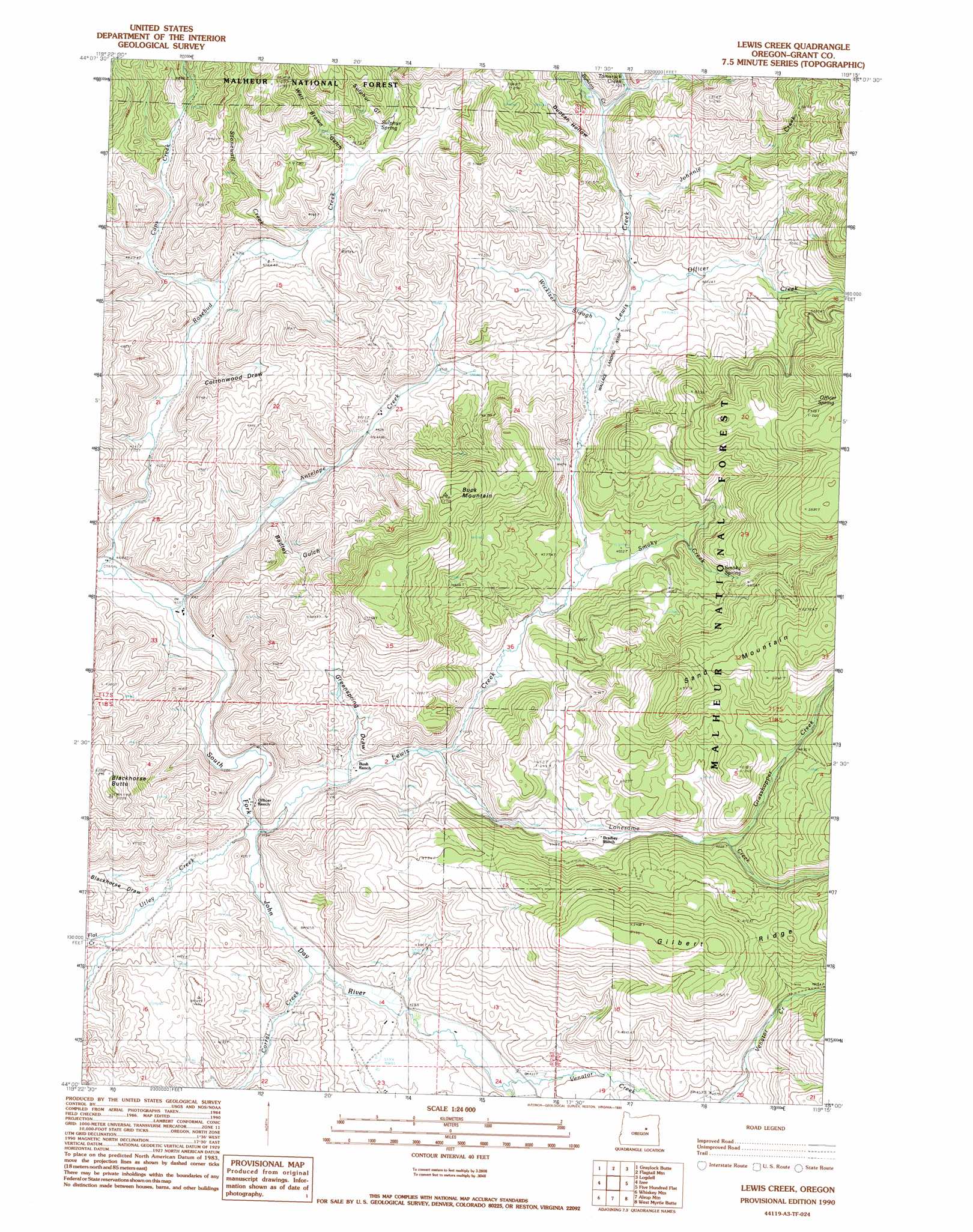
USGS Topo Quad 44119a3 - 1:24,000 scale
| Topo Map Name: | Lewis Creek |
| USGS Topo Quad ID: | 44119a3 |
| Print Size: | ca. 21 1/4" wide x 27" high |
| Southeast Coordinates: | 44° N latitude / 119.25° W longitude |
| Map Center Coordinates: | 44.0625° N latitude / 119.3125° W longitude |
| U.S. State: | OR |
| Filename: | o44119a3.jpg |
| Download Map JPG Image: | Lewis Creek topo map 1:24,000 scale |
| Map Type: | Topographic |
| Topo Series: | 7.5´ |
| Map Scale: | 1:24,000 |
| Source of Map Images: | United States Geological Survey (USGS) |
| Alternate Map Versions: |
Lewis Creek OR 1990, updated 1990 Download PDF Buy paper map Lewis Creek OR 1998, updated 2000 Download PDF Buy paper map Lewis Creek OR 2011 Download PDF Buy paper map Lewis Creek OR 2014 Download PDF Buy paper map |
| FStopo: | US Forest Service topo Lewis Creek is available: Download FStopo PDF Download FStopo TIF |
1:24,000 Topo Quads surrounding Lewis Creek
Aldrich Gulch |
Aldrich Mountain South |
Big Weasel Sprs |
Mcclellan Mountain |
Fall Mountain |
Suplee Butte |
Graylock Butte |
Flagtail Mountain |
Logdell |
Scotty Creek |
Funny Butte |
Izee |
Lewis Creek |
Five Hundred Flat |
Rail Creek Butte |
Big Mowich Mountain |
Whiskey Mountain |
Alsup Mountain |
West Myrtle Butte |
Myrtle Park Meadows |
Donnelly Butte |
Bear Canyon Butte |
Hughet Valley |
Landing Creek |
Mosquito Flat |
> Back to 44119a1 at 1:100,000 scale
> Back to 44118a1 at 1:250,000 scale
> Back to U.S. Topo Maps home
Lewis Creek topo map: Gazetteer
Lewis Creek: Airports
Wallace Ranch Airstrip elevation 1391m 4563′Lewis Creek: Reservoirs
Chappel Gulch Reservoir elevation 1507m 4944′Lewis Creek: Springs
Officer Spring elevation 1592m 5223′Smoky Spring elevation 1447m 4747′
Sulphur Spring elevation 1412m 4632′
Wickiser Spring elevation 1465m 4806′
Lewis Creek: Streams
Antelope Creek elevation 1255m 4117′Bunton Creek elevation 1423m 4668′
Caps Creek elevation 1311m 4301′
Corral Creek elevation 1290m 4232′
Flat Creek elevation 1279m 4196′
Grasshopper Creek elevation 1420m 4658′
Johnnie Creek elevation 1402m 4599′
Lewis Creek elevation 1280m 4199′
Lonesome Creek elevation 1315m 4314′
Officer Creek elevation 1388m 4553′
Smoky Creek elevation 1353m 4438′
Stonewall Creek elevation 1341m 4399′
Tamarack Creek elevation 1436m 4711′
Utley Creek elevation 1302m 4271′
Venator Creek elevation 1316m 4317′
Wickiser Slough elevation 1382m 4534′
Lewis Creek: Summits
Blackhorse Butte elevation 1596m 5236′Buck Mountain elevation 1607m 5272′
Sand Mountain elevation 1663m 5456′
Lewis Creek: Valleys
Badley Gulch elevation 1309m 4294′Blackhorse Draw elevation 1312m 4304′
Chappel Gulch elevation 1331m 4366′
Cottonwood Draw elevation 1309m 4294′
Duncan Hollow elevation 1422m 4665′
Greenspring Draw elevation 1302m 4271′
Road Gulch elevation 1382m 4534′
Sulphur Gulch elevation 1422m 4665′
Walt Brown Gulch elevation 1380m 4527′
Lewis Creek digital topo map on disk
Buy this Lewis Creek topo map showing relief, roads, GPS coordinates and other geographical features, as a high-resolution digital map file on DVD: