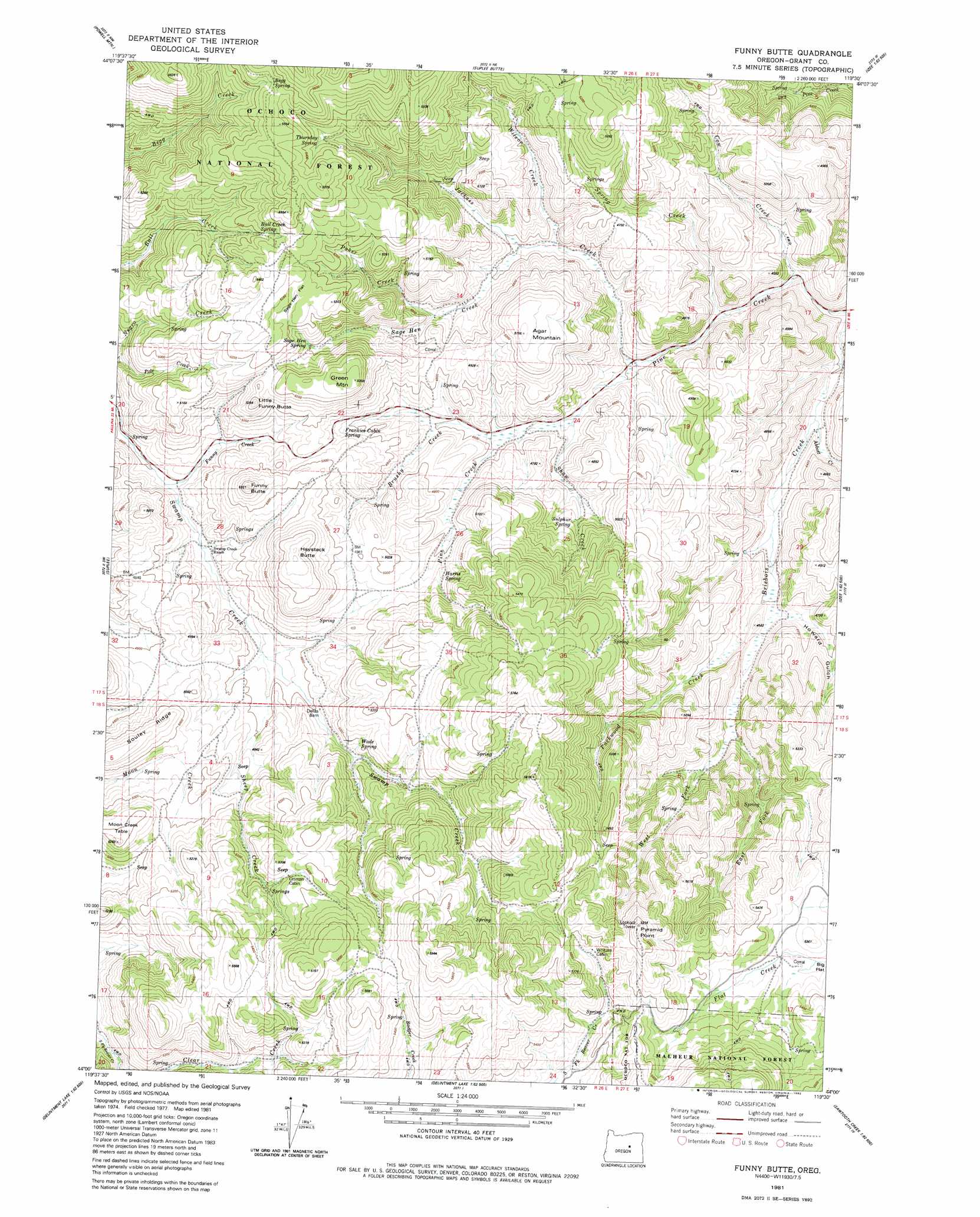
Funny Butte Topo Map Oregon
To zoom in, hover over the map of Funny Butte
USGS Topo Quad 44119a5 - 1:24,000 scale
| Topo Map Name: | Funny Butte |
| USGS Topo Quad ID: | 44119a5 |
| Print Size: | ca. 21 1/4" wide x 27" high |
| Southeast Coordinates: | 44° N latitude / 119.5° W longitude |
| Map Center Coordinates: | 44.0625° N latitude / 119.5625° W longitude |
| U.S. State: | OR |
| Filename: | o44119a5.jpg |
| Download Map JPG Image: | Funny Butte topo map 1:24,000 scale |
| Map Type: | Topographic |
| Topo Series: | 7.5´ |
| Map Scale: | 1:24,000 |
| Source of Map Images: | United States Geological Survey (USGS) |
| Alternate Map Versions: |
Funny Butte OR 1981, updated 1982 Download PDF Buy paper map Funny Butte OR 1992, updated 1997 Download PDF Buy paper map Funny Butte OR 2011 Download PDF Buy paper map Funny Butte OR 2014 Download PDF Buy paper map |
| FStopo: | US Forest Service topo Funny Butte is available: Download FStopo PDF Download FStopo TIF |
1:24,000 Topo Quads surrounding Funny Butte
Six Corners |
Wolf Mountain |
Aldrich Gulch |
Aldrich Mountain South |
Big Weasel Sprs |
Mud Spring |
Powell Mountain |
Suplee Butte |
Graylock Butte |
Flagtail Mountain |
Angell Butte |
Suplee |
Funny Butte |
Izee |
Lewis Creek |
Twelvemile Reservoir |
Delintment Lake |
Big Mowich Mountain |
Whiskey Mountain |
Alsup Mountain |
Mackey Butte |
Buck Spring |
Donnelly Butte |
Bear Canyon Butte |
Hughet Valley |
> Back to 44119a1 at 1:100,000 scale
> Back to 44118a1 at 1:250,000 scale
> Back to U.S. Topo Maps home
Funny Butte topo map: Gazetteer
Funny Butte: Flats
Sage Hen Flat elevation 1599m 5246′Funny Butte: Springs
Bull Creek Spring elevation 1589m 5213′Frankies Cabin Spring elevation 1473m 4832′
Sulphur Spring elevation 1445m 4740′
Thursday Spring elevation 1617m 5305′
Funny Butte: Streams
Abbott Creek elevation 1266m 4153′Brushy Creek elevation 1402m 4599′
East Fork Brisbois Creek elevation 1399m 4589′
Jackass Creek elevation 1340m 4396′
Parker Creek elevation 1431m 4694′
Shaw Creek elevation 1365m 4478′
Spring Creek elevation 1312m 4304′
Swamp Creek elevation 1416m 4645′
West Fork Brisbois Creek elevation 1399m 4589′
Wilson Creek elevation 1381m 4530′
Funny Butte: Summits
Funny Butte elevation 1578m 5177′Green Mountain elevation 1628m 5341′
Little Funny Butte elevation 1604m 5262′
Funny Butte digital topo map on disk
Buy this Funny Butte topo map showing relief, roads, GPS coordinates and other geographical features, as a high-resolution digital map file on DVD: