Mud Spring Topo Map Oregon
To zoom in, hover over the map of Mud Spring
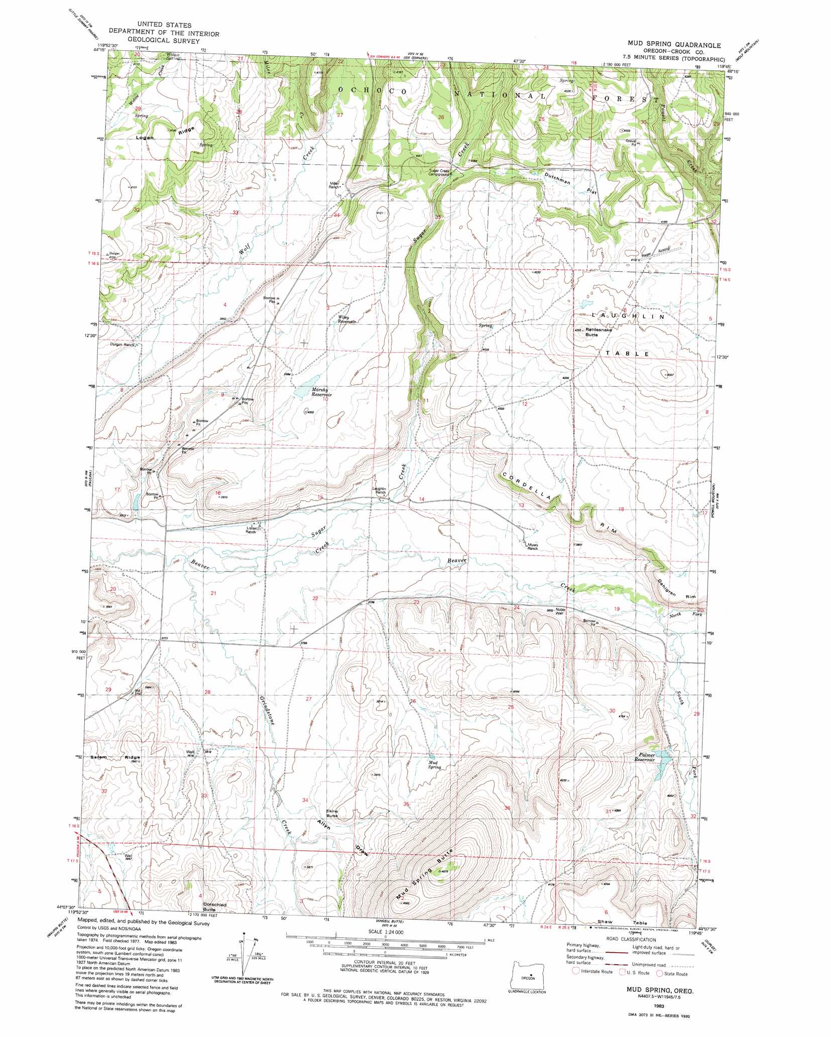
USGS Topo Quad 44119b7 - 1:24,000 scale
| Topo Map Name: | Mud Spring |
| USGS Topo Quad ID: | 44119b7 |
| Print Size: | ca. 21 1/4" wide x 27" high |
| Southeast Coordinates: | 44.125° N latitude / 119.75° W longitude |
| Map Center Coordinates: | 44.1875° N latitude / 119.8125° W longitude |
| U.S. State: | OR |
| Filename: | o44119b7.jpg |
| Download Map JPG Image: | Mud Spring topo map 1:24,000 scale |
| Map Type: | Topographic |
| Topo Series: | 7.5´ |
| Map Scale: | 1:24,000 |
| Source of Map Images: | United States Geological Survey (USGS) |
| Alternate Map Versions: |
Mud Spring OR 1983, updated 1983 Download PDF Buy paper map Mud Spring OR 1992, updated 1997 Download PDF Buy paper map Mud Spring OR 2011 Download PDF Buy paper map Mud Spring OR 2014 Download PDF Buy paper map |
| FStopo: | US Forest Service topo Mud Spring is available: Download FStopo PDF Download FStopo TIF |
1:24,000 Topo Quads surrounding Mud Spring
Peterson Point |
Derr Meadows |
Antone |
Day Basin |
Dayville |
Keys Creek |
Little Summit Prairie |
Six Corners |
Wolf Mountain |
Aldrich Gulch |
Rabbit Valley |
Paulina |
Mud Spring |
Powell Mountain |
Suplee Butte |
Liggett Table |
Maupin Butte |
Angell Butte |
Suplee |
Funny Butte |
Sand Hollow |
Hardin Ranch |
Twelvemile Reservoir |
Delintment Lake |
Big Mowich Mountain |
> Back to 44119a1 at 1:100,000 scale
> Back to 44118a1 at 1:250,000 scale
> Back to U.S. Topo Maps home
Mud Spring topo map: Gazetteer
Mud Spring: Airports
Rager Airstrip elevation 1281m 4202′Mud Spring: Cliffs
Cordella Rim elevation 1208m 3963′Dahlgren Rim elevation 1239m 4064′
Mud Spring: Dams
Palmer Dam elevation 1194m 3917′Mud Spring: Flats
Dutchman Flat elevation 1244m 4081′Mud Spring: Reservoirs
Marshy Reservoir elevation 1215m 3986′Palmer Reservoir elevation 1196m 3923′
Mud Spring: Ridges
Logan Ridge elevation 1263m 4143′Salem Ridge elevation 1208m 3963′
Mud Spring: Springs
Juniper Basin Spring elevation 1317m 4320′Mud Spring elevation 1185m 3887′
Sugar Creek Spring elevation 1267m 4156′
Widow Spring elevation 1260m 4133′
Mud Spring: Streams
Grindstone Creek elevation 1144m 3753′Miles Creek elevation 1182m 3877′
North Fork Beaver Creek elevation 1172m 3845′
South Fork Beaver Creek elevation 1172m 3845′
Sugar Creek elevation 1155m 3789′
Mud Spring: Summits
Elkins Butte elevation 1200m 3937′Laughlin Table elevation 1305m 4281′
Mud Spring Butte elevation 1278m 4192′
Powell Valley Butte elevation 1312m 4304′
Rattlesnake Butte elevation 1307m 4288′
Mud Spring: Valleys
Allyn Draw elevation 1163m 3815′Mud Spring: Wells
Noble Well elevation 1174m 3851′Mud Spring digital topo map on disk
Buy this Mud Spring topo map showing relief, roads, GPS coordinates and other geographical features, as a high-resolution digital map file on DVD: