Aldrich Mountain North Topo Map Oregon
To zoom in, hover over the map of Aldrich Mountain North
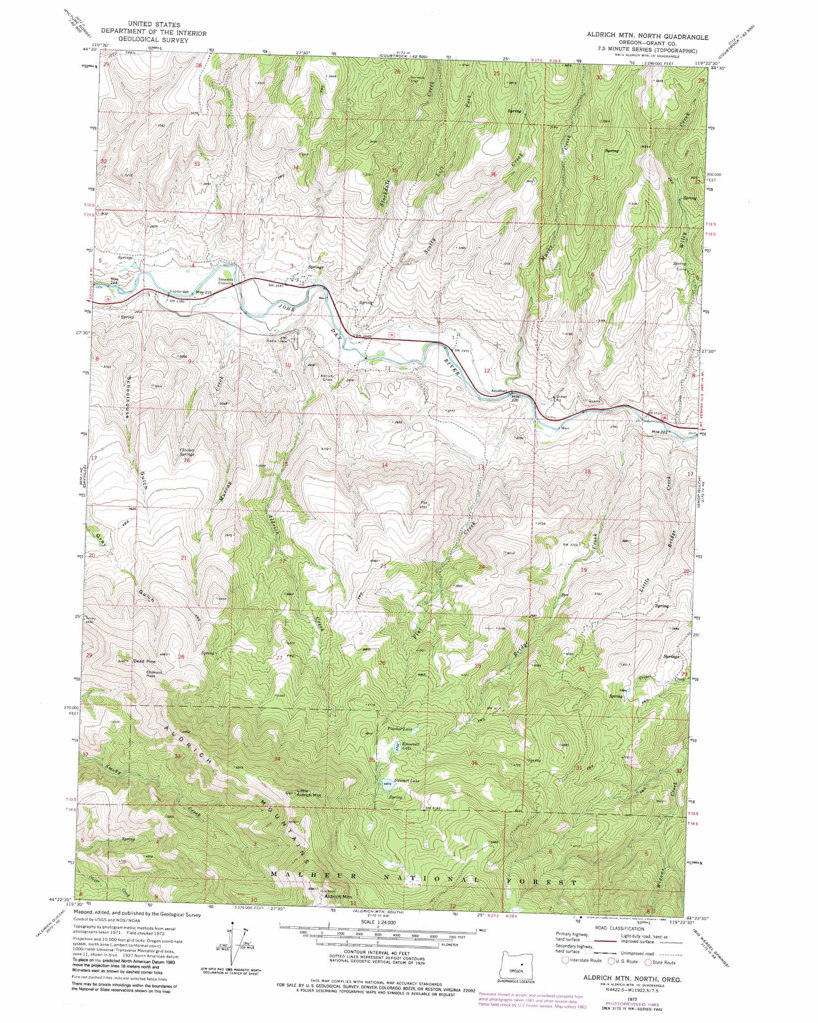
USGS Topo Quad 44119d4 - 1:24,000 scale
| Topo Map Name: | Aldrich Mountain North |
| USGS Topo Quad ID: | 44119d4 |
| Print Size: | ca. 21 1/4" wide x 27" high |
| Southeast Coordinates: | 44.375° N latitude / 119.375° W longitude |
| Map Center Coordinates: | 44.4375° N latitude / 119.4375° W longitude |
| U.S. State: | OR |
| Filename: | o44119d4.jpg |
| Download Map JPG Image: | Aldrich Mountain North topo map 1:24,000 scale |
| Map Type: | Topographic |
| Topo Series: | 7.5´ |
| Map Scale: | 1:24,000 |
| Source of Map Images: | United States Geological Survey (USGS) |
| Alternate Map Versions: |
Aldrich Mountain North OR 1972, updated 1976 Download PDF Buy paper map Aldrich Mountain North OR 1972, updated 1984 Download PDF Buy paper map Aldrich Mountain North OR 1998, updated 2000 Download PDF Buy paper map Aldrich Mountain North OR 2011 Download PDF Buy paper map Aldrich Mountain North OR 2014 Download PDF Buy paper map |
| FStopo: | US Forest Service topo Aldrich Mountain North is available: Download FStopo PDF Download FStopo TIF |
1:24,000 Topo Quads surrounding Aldrich Mountain North
Mount Misery |
Miller Flat |
Courthouse Rock |
Hamilton |
Fox |
Picture Gorge West |
Picture Gorge East |
Sheep Ridge |
Donaldson Creek |
Belshaw Meadows |
Day Basin |
Dayville |
Aldrich Mountain North |
Shop Gulch |
Wolfinger Butte |
Wolf Mountain |
Aldrich Gulch |
Aldrich Mountain South |
Big Weasel Sprs |
Mcclellan Mountain |
Powell Mountain |
Suplee Butte |
Graylock Butte |
Flagtail Mountain |
Logdell |
> Back to 44119a1 at 1:100,000 scale
> Back to 44118a1 at 1:250,000 scale
> Back to U.S. Topo Maps home
Aldrich Mountain North topo map: Gazetteer
Aldrich Mountain North: Canals
Steward Ditch elevation 756m 2480′Stewart Ditch elevation 756m 2480′
Aldrich Mountain North: Gaps
Chilkoot Pass elevation 1488m 4881′Aldrich Mountain North: Lakes
Stewart Lake elevation 1484m 4868′Aldrich Mountain North: Reservoirs
Pinchot Lake elevation 1411m 4629′Roosevelt Lake elevation 1444m 4737′
Aldrich Mountain North: Springs
Chicken Springs elevation 995m 3264′Lick Spring elevation 1245m 4084′
Aldrich Mountain North: Streams
Aldrich Creek elevation 740m 2427′Bridge Creek elevation 766m 2513′
Flat Creek elevation 759m 2490′
Left Fork Scotty Creek elevation 856m 2808′
Little Bridge Creek elevation 768m 2519′
Marks Creek elevation 751m 2463′
Murray Creek elevation 733m 2404′
Scotty Creek elevation 738m 2421′
Stockdale Creek elevation 734m 2408′
Wiley Creek elevation 767m 2516′
Aldrich Mountain North: Summits
Aldrich Mountain elevation 2127m 6978′Dead Pine elevation 1562m 5124′
Little Aldrich Mountain elevation 1898m 6227′
Aldrich Mountain North: Valleys
Schoolhouse Gulch elevation 716m 2349′Aldrich Mountain North digital topo map on disk
Buy this Aldrich Mountain North topo map showing relief, roads, GPS coordinates and other geographical features, as a high-resolution digital map file on DVD: