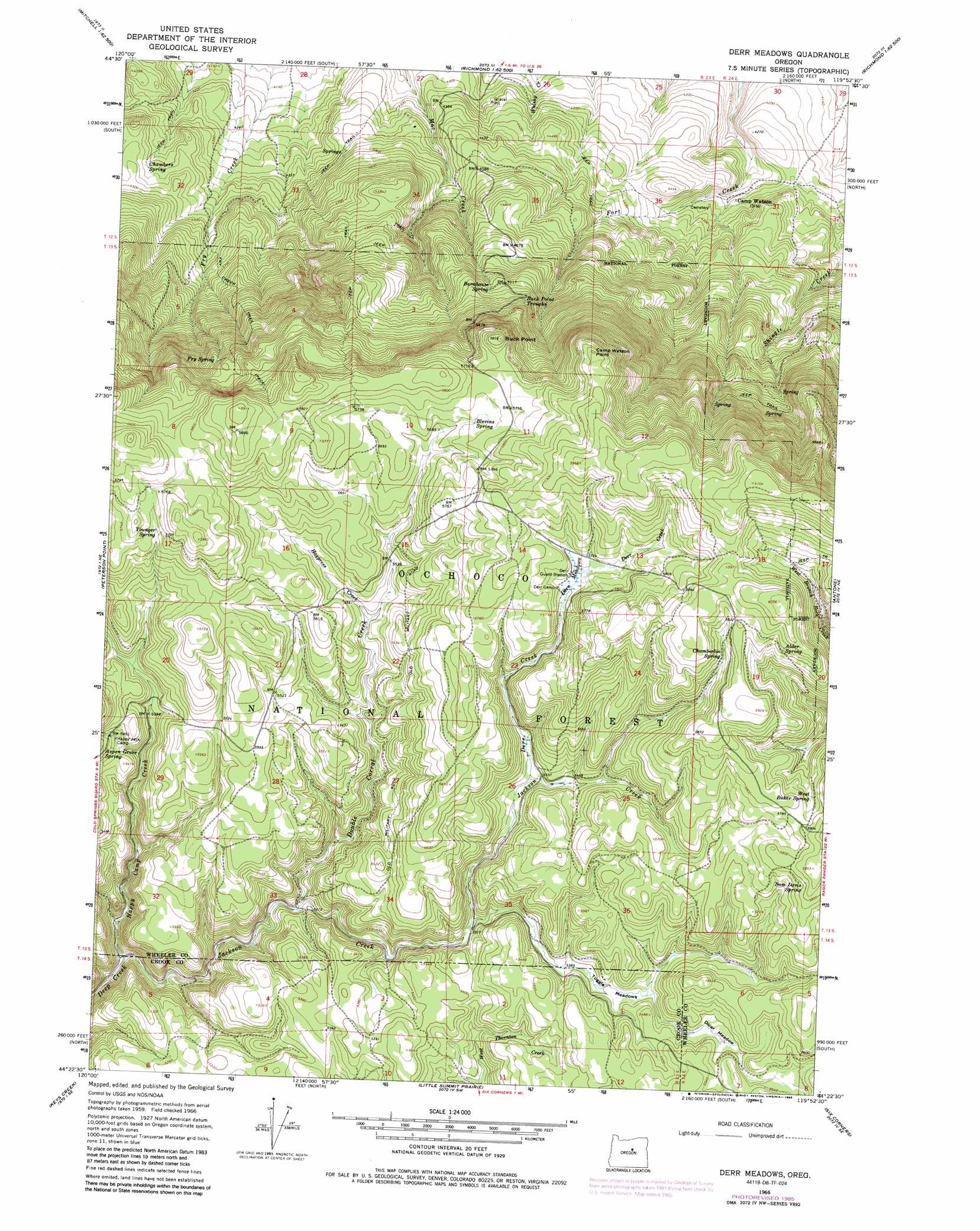
Derr Meadows Topo Map Oregon
To zoom in, hover over the map of Derr Meadows
USGS Topo Quad 44119d8 - 1:24,000 scale
| Topo Map Name: | Derr Meadows |
| USGS Topo Quad ID: | 44119d8 |
| Print Size: | ca. 21 1/4" wide x 27" high |
| Southeast Coordinates: | 44.375° N latitude / 119.875° W longitude |
| Map Center Coordinates: | 44.4375° N latitude / 119.9375° W longitude |
| U.S. State: | OR |
| Filename: | o44119d8.jpg |
| Download Map JPG Image: | Derr Meadows topo map 1:24,000 scale |
| Map Type: | Topographic |
| Topo Series: | 7.5´ |
| Map Scale: | 1:24,000 |
| Source of Map Images: | United States Geological Survey (USGS) |
| Alternate Map Versions: |
Derr Meadows OR 1966, updated 1968 Download PDF Buy paper map Derr Meadows OR 1966, updated 1985 Download PDF Buy paper map Derr Meadows OR 1992, updated 1997 Download PDF Buy paper map Derr Meadows OR 2011 Download PDF Buy paper map Derr Meadows OR 2014 Download PDF Buy paper map |
| FStopo: | US Forest Service topo Derr Meadows is available: Download FStopo PDF Download FStopo TIF |
1:24,000 Topo Quads surrounding Derr Meadows
Sutton Mountain |
Toney Butte |
Richmond |
Johnson Heights |
Mount Misery |
Mitchell |
Keyes Mountain |
Frog Hollow |
Tubb Spring |
Picture Gorge West |
Mount Pisgah |
Peterson Point |
Derr Meadows |
Antone |
Day Basin |
Williams Prairie |
Keys Creek |
Little Summit Prairie |
Six Corners |
Wolf Mountain |
Committee Creek |
Rabbit Valley |
Paulina |
Mud Spring |
Powell Mountain |
> Back to 44119a1 at 1:100,000 scale
> Back to 44118a1 at 1:250,000 scale
> Back to U.S. Topo Maps home
Derr Meadows topo map: Gazetteer
Derr Meadows: Capes
Camp Watson Point elevation 1798m 5898′Derr Meadows: Flats
Dicer Meadow elevation 1672m 5485′Toggle Meadows elevation 1649m 5410′
Derr Meadows: Post Offices
Camp Watson Post Office (historical) elevation 1289m 4229′Derr Meadows: Springs
Alder Spring elevation 1813m 5948′Aspen Grove Spring elevation 1662m 5452′
Barnhouse Spring elevation 1565m 5134′
Blevins Spring elevation 1745m 5725′
Buck Point Troughs elevation 1608m 5275′
Chamberlin Spring elevation 1780m 5839′
Chambers Spring elevation 1349m 4425′
Fry Spring elevation 1647m 5403′
Sam Davis Spring elevation 1772m 5813′
West Buker Spring elevation 1762m 5780′
Younger Spring elevation 1751m 5744′
Derr Meadows: Streams
Cabbage Creek elevation 1662m 5452′Derr Creek elevation 1661m 5449′
Double Corral Creek elevation 1579m 5180′
Happy Camp Creek elevation 1524m 5000′
Haypress Creek elevation 1676m 5498′
Jackson Creek elevation 1524m 5000′
Taggle Creek elevation 1621m 5318′
Derr Meadows: Summits
Buck Point elevation 1777m 5830′Derr Meadows: Swamps
Derr Meadows elevation 1741m 5711′Derr Meadows digital topo map on disk
Buy this Derr Meadows topo map showing relief, roads, GPS coordinates and other geographical features, as a high-resolution digital map file on DVD: