Gerow Butte Topo Map Oregon
To zoom in, hover over the map of Gerow Butte
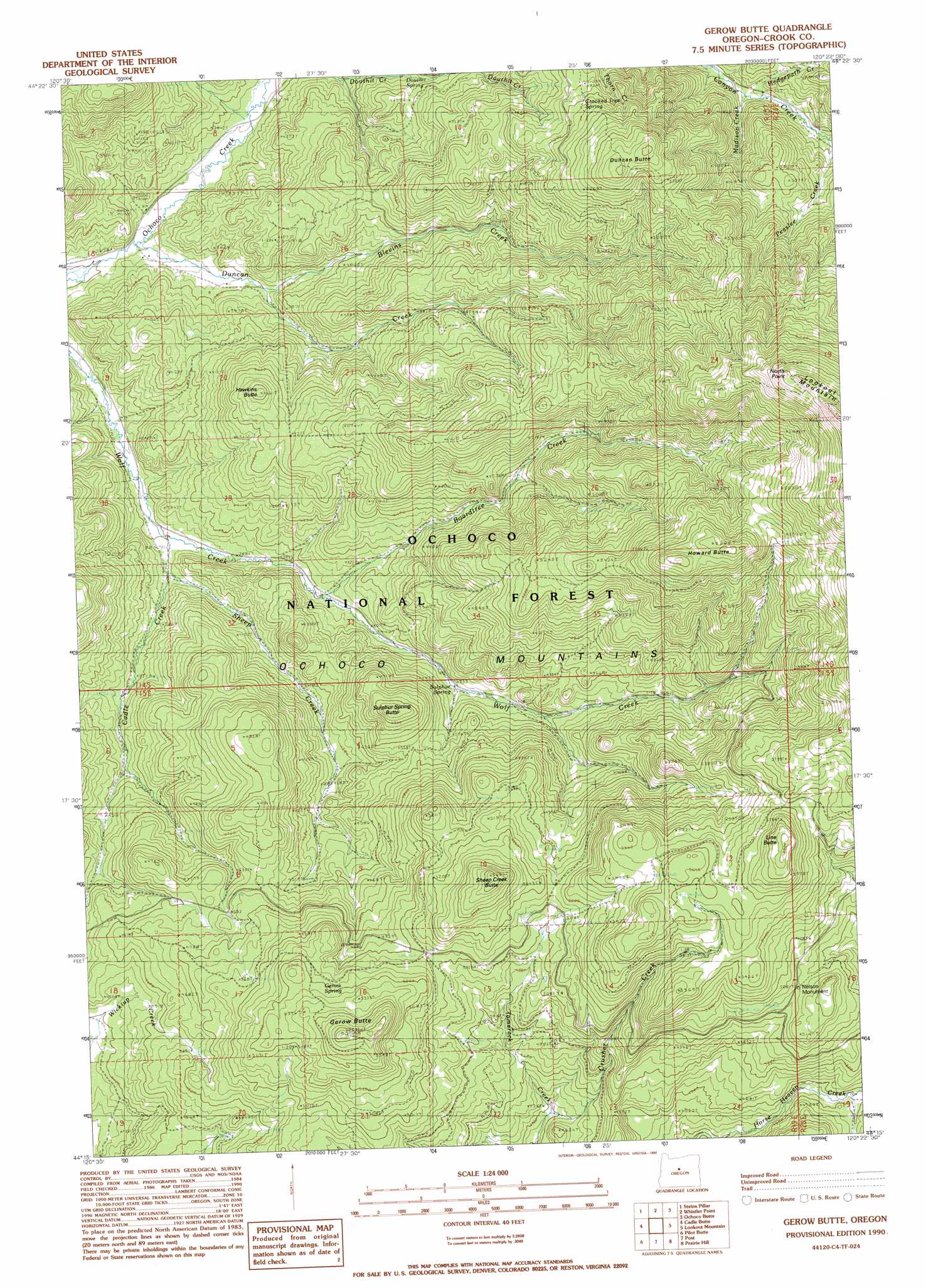
USGS Topo Quad 44120c4 - 1:24,000 scale
| Topo Map Name: | Gerow Butte |
| USGS Topo Quad ID: | 44120c4 |
| Print Size: | ca. 21 1/4" wide x 27" high |
| Southeast Coordinates: | 44.25° N latitude / 120.375° W longitude |
| Map Center Coordinates: | 44.3125° N latitude / 120.4375° W longitude |
| U.S. State: | OR |
| Filename: | o44120c4.jpg |
| Download Map JPG Image: | Gerow Butte topo map 1:24,000 scale |
| Map Type: | Topographic |
| Topo Series: | 7.5´ |
| Map Scale: | 1:24,000 |
| Source of Map Images: | United States Geological Survey (USGS) |
| Alternate Map Versions: |
Gerow Butte OR 1990, updated 1990 Download PDF Buy paper map Gerow Butte OR 1992, updated 1997 Download PDF Buy paper map Gerow Butte OR 2011 Download PDF Buy paper map Gerow Butte OR 2014 Download PDF Buy paper map |
| FStopo: | US Forest Service topo Gerow Butte is available: Download FStopo PDF Download FStopo TIF |
1:24,000 Topo Quads surrounding Gerow Butte
Dutchman Creek |
Opal Mountain |
Stephenson Mountain |
Lawson Mountain |
Mitchell |
Salt Butte |
Wildcat Mountain |
Whistler Point |
Ochoco Butte |
Mount Pisgah |
Ochoco Reservoir |
Cadle Butte |
Gerow Butte |
Lookout Mountain |
Williams Prairie |
Eagle Rock |
Pilot Butte |
Post |
Prairie Hill |
Committee Creek |
Alkali Flat |
Conant Basin |
Mule Deer Ridge |
Drake Butte |
Arrowwood Point |
> Back to 44120a1 at 1:100,000 scale
> Back to 44120a1 at 1:250,000 scale
> Back to U.S. Topo Maps home
Gerow Butte topo map: Gazetteer
Gerow Butte: Parks
Nelson Monument elevation 1549m 5082′Gerow Butte: Springs
Crooked Tree Spring elevation 1506m 4940′Gerow Spring elevation 1568m 5144′
Monument Spring elevation 1407m 4616′
Sulphur Spring elevation 1290m 4232′
Gerow Butte: Streams
Blevins Creek elevation 1162m 3812′Boardtree Creek elevation 1228m 4028′
Cadle Creek elevation 1159m 3802′
Crusher Creek elevation 1340m 4396′
Duncan Creek elevation 1111m 3645′
Hedgepath Creek elevation 1351m 4432′
Kyle Creek elevation 1396m 4580′
Madison Creek elevation 1349m 4425′
Peaslee Creek elevation 1391m 4563′
Sheep Creek elevation 1171m 3841′
Gerow Butte: Summits
Duncan Butte elevation 1709m 5606′Gerow Butte elevation 1732m 5682′
Hawkins Butte elevation 1419m 4655′
Howard Butte elevation 1831m 6007′
Line Butte elevation 1806m 5925′
North Point elevation 2037m 6683′
Sheep Creek Butte elevation 1723m 5652′
Sulphur Spring Butte elevation 1504m 4934′
Gerow Butte digital topo map on disk
Buy this Gerow Butte topo map showing relief, roads, GPS coordinates and other geographical features, as a high-resolution digital map file on DVD: