Peterson Point Topo Map Oregon
To zoom in, hover over the map of Peterson Point
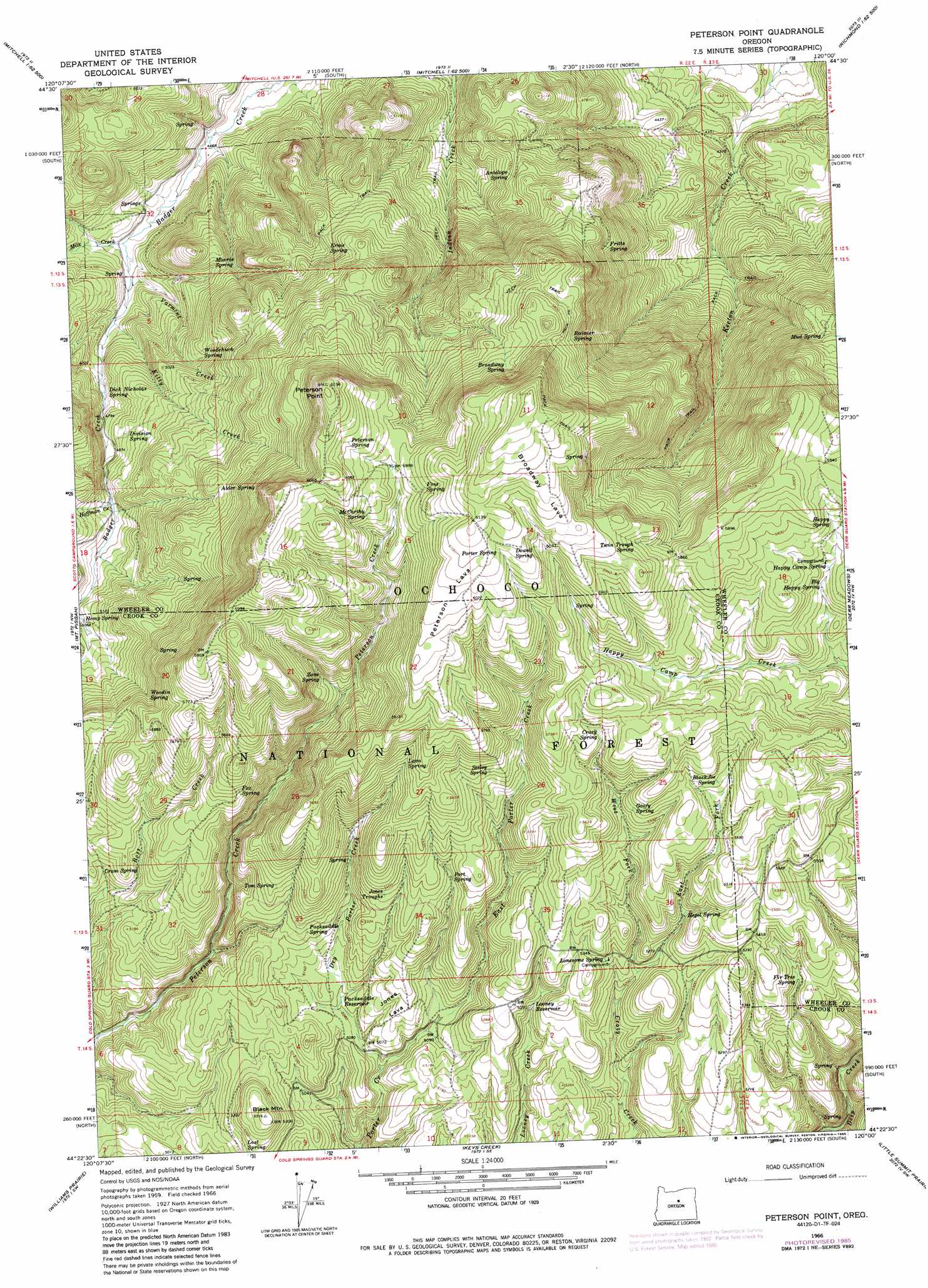
USGS Topo Quad 44120d1 - 1:24,000 scale
| Topo Map Name: | Peterson Point |
| USGS Topo Quad ID: | 44120d1 |
| Print Size: | ca. 21 1/4" wide x 27" high |
| Southeast Coordinates: | 44.375° N latitude / 120° W longitude |
| Map Center Coordinates: | 44.4375° N latitude / 120.0625° W longitude |
| U.S. State: | OR |
| Filename: | o44120d1.jpg |
| Download Map JPG Image: | Peterson Point topo map 1:24,000 scale |
| Map Type: | Topographic |
| Topo Series: | 7.5´ |
| Map Scale: | 1:24,000 |
| Source of Map Images: | United States Geological Survey (USGS) |
| Alternate Map Versions: |
Peterson Point OR 1966, updated 1968 Download PDF Buy paper map Peterson Point OR 1966, updated 1985 Download PDF Buy paper map Peterson Point OR 1992, updated 1997 Download PDF Buy paper map Peterson Point OR 2011 Download PDF Buy paper map Peterson Point OR 2014 Download PDF Buy paper map |
| FStopo: | US Forest Service topo Peterson Point is available: Download FStopo PDF Download FStopo TIF |
1:24,000 Topo Quads surrounding Peterson Point
Painted Hills |
Sutton Mountain |
Toney Butte |
Richmond |
Johnson Heights |
Lawson Mountain |
Mitchell |
Keyes Mountain |
Frog Hollow |
Tubb Spring |
Ochoco Butte |
Mount Pisgah |
Peterson Point |
Derr Meadows |
Antone |
Lookout Mountain |
Williams Prairie |
Keys Creek |
Little Summit Prairie |
Six Corners |
Prairie Hill |
Committee Creek |
Rabbit Valley |
Paulina |
Mud Spring |
> Back to 44120a1 at 1:100,000 scale
> Back to 44120a1 at 1:250,000 scale
> Back to U.S. Topo Maps home
Peterson Point topo map: Gazetteer
Peterson Point: Forests
Ochoco National Forest elevation 1527m 5009′Peterson Point: Lavas
Broadway Lava elevation 1876m 6154′Jones Lava elevation 1588m 5209′
Peterson Lava elevation 1847m 6059′
Peterson Point: Reservoirs
Looney Reservoir elevation 1590m 5216′Packsaddle Reservoir elevation 1552m 5091′
Peterson Point: Springs
Alder Spring elevation 1658m 5439′Antelope Spring elevation 1553m 5095′
Big Happy Spring elevation 1718m 5636′
Blackjoe Spring elevation 1692m 5551′
Broadway Spring elevation 1762m 5780′
Cram Spring elevation 1583m 5193′
Crazy Spring elevation 1724m 5656′
Dick Nickolas Spring elevation 1450m 4757′
Division Spring elevation 1510m 4954′
Dowell Spring elevation 1826m 5990′
Ernie Spring elevation 1593m 5226′
Fir Tree Spring elevation 1613m 5291′
Foss Spring elevation 1821m 5974′
Fox Spring elevation 1678m 5505′
Fritts Spring elevation 1580m 5183′
Go Spring elevation 1621m 5318′
Goofy Spring elevation 1692m 5551′
Happy Camp Spring elevation 1730m 5675′
Happy Spring elevation 1750m 5741′
Hegel Spring elevation 1630m 5347′
Jones Troughs elevation 1636m 5367′
Lava Spring elevation 1715m 5626′
Little Happy Spring elevation 1742m 5715′
Lonesome Spring elevation 1611m 5285′
Lost Spring elevation 1573m 5160′
McCarthy Spring elevation 1798m 5898′
Monroe Spring elevation 1487m 4878′
Mud Spring elevation 1640m 5380′
Packsaddle Spring elevation 1598m 5242′
Peter Spring elevation 1569m 5147′
Peterson Spring elevation 1837m 6026′
Port Spring elevation 1643m 5390′
Porter Spring elevation 1845m 6053′
Rainier Spring elevation 1738m 5702′
Seeley Spring elevation 1703m 5587′
Tom Spring elevation 1634m 5360′
Twin Trough Spring elevation 1796m 5892′
Woodchuck Spring elevation 1520m 4986′
Woodin Spring elevation 1654m 5426′
Zane Spring elevation 1688m 5538′
Peterson Point: Streams
Dry Porter Creek elevation 1533m 5029′East Fork Crazy Creek elevation 1591m 5219′
East Porter Creek elevation 1533m 5029′
Hoffman Creek elevation 1518m 4980′
Kitty Creek elevation 1418m 4652′
Milk Creek elevation 1394m 4573′
Varmint Creek elevation 1403m 4603′
West Fork Crazy Creek elevation 1591m 5219′
Peterson Point: Summits
Black Mountain elevation 1619m 5311′Peterson Point elevation 1891m 6204′
Peterson Point digital topo map on disk
Buy this Peterson Point topo map showing relief, roads, GPS coordinates and other geographical features, as a high-resolution digital map file on DVD: