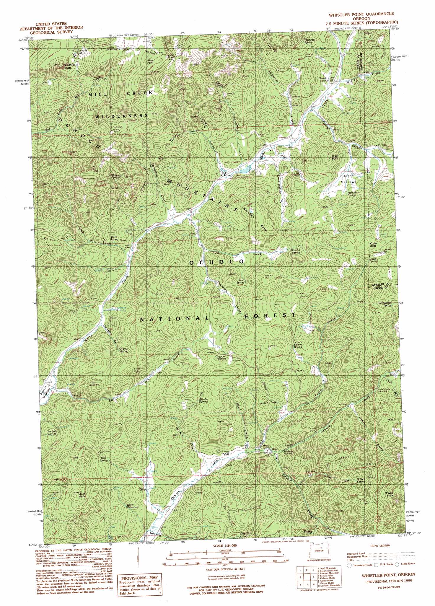
Whistler Point Topo Map Oregon
To zoom in, hover over the map of Whistler Point
USGS Topo Quad 44120d4 - 1:24,000 scale
| Topo Map Name: | Whistler Point |
| USGS Topo Quad ID: | 44120d4 |
| Print Size: | ca. 21 1/4" wide x 27" high |
| Southeast Coordinates: | 44.375° N latitude / 120.375° W longitude |
| Map Center Coordinates: | 44.4375° N latitude / 120.4375° W longitude |
| U.S. State: | OR |
| Filename: | o44120d4.jpg |
| Download Map JPG Image: | Whistler Point topo map 1:24,000 scale |
| Map Type: | Topographic |
| Topo Series: | 7.5´ |
| Map Scale: | 1:24,000 |
| Source of Map Images: | United States Geological Survey (USGS) |
| Alternate Map Versions: |
Whistler Point OR 1990, updated 1990 Download PDF Buy paper map Whistler Point OR 1992, updated 1997 Download PDF Buy paper map Whistler Point OR 1992, updated 1997 Download PDF Buy paper map Whistler Point OR 2011 Download PDF Buy paper map Whistler Point OR 2014 Download PDF Buy paper map |
| FStopo: | US Forest Service topo Whistler Point is available: Download FStopo PDF Download FStopo TIF |
1:24,000 Topo Quads surrounding Whistler Point
Axehandle Butte |
Horse Heaven Creek |
Sandrock Mountain |
Painted Hills |
Sutton Mountain |
Dutchman Creek |
Opal Mountain |
Stephenson Mountain |
Lawson Mountain |
Mitchell |
Salt Butte |
Wildcat Mountain |
Whistler Point |
Ochoco Butte |
Mount Pisgah |
Ochoco Reservoir |
Cadle Butte |
Gerow Butte |
Lookout Mountain |
Williams Prairie |
Eagle Rock |
Pilot Butte |
Post |
Prairie Hill |
Committee Creek |
> Back to 44120a1 at 1:100,000 scale
> Back to 44120a1 at 1:250,000 scale
> Back to U.S. Topo Maps home
Whistler Point topo map: Gazetteer
Whistler Point: Dams
Marks Lake Dam elevation 1321m 4333′Whistler Point: Flats
Carroll Flat elevation 1432m 4698′Grant Meadows elevation 1413m 4635′
Spears Meadow elevation 1235m 4051′
Whistler Point: Ranges
Ochoco Mountains elevation 1673m 5488′Whistler Point: Reservoirs
Cox Reservoir elevation 1448m 4750′Koch Reservoir elevation 1232m 4041′
Marks Lake elevation 1321m 4333′
Section Eight Reservoir elevation 1234m 4048′
Whitney Reservoir elevation 1437m 4714′
Whistler Point: Springs
Bandit Spring elevation 1389m 4557′Buck Spring elevation 1303m 4274′
Claypool Spring elevation 1418m 4652′
Coyle Spring elevation 1628m 5341′
Douthit Springs elevation 1248m 4094′
Downs Spring elevation 1439m 4721′
Garden Spring elevation 1401m 4596′
Halfway Spring elevation 1510m 4954′
Hamilton Spring elevation 1449m 4753′
Hon Spring elevation 1299m 4261′
Mahogany Spring elevation 1558m 5111′
Marks Spring elevation 1347m 4419′
Mud Spring elevation 1631m 5351′
O'Neil Spring elevation 1427m 4681′
Pothole Spring elevation 1309m 4294′
Rush Spring elevation 1406m 4612′
Stewart Spring elevation 1456m 4776′
Whistler Spring elevation 1711m 5613′
Wickheiser Spring elevation 1630m 5347′
Whistler Point: Streams
Buck Creek elevation 1269m 4163′Canyon Creek elevation 1228m 4028′
Cornez Creek elevation 1315m 4314′
Coyle Creek elevation 1216m 3989′
Crystal Creek elevation 1360m 4461′
Deadman Creek elevation 1322m 4337′
Douthit Creek elevation 1144m 3753′
Fisher Creek elevation 1296m 4251′
Garden Creek elevation 1191m 3907′
Hamilton Creek elevation 1289m 4229′
Judy Creek elevation 1341m 4399′
Little Hay Creek elevation 1232m 4041′
Long Hollow Creek elevation 1328m 4356′
McGinnis Creek elevation 1340m 4396′
Mercury Creek elevation 1241m 4071′
Metal Creek elevation 1216m 3989′
Nature Creek elevation 1382m 4534′
O'Neil Creek elevation 1257m 4124′
Rail Creek elevation 1330m 4363′
Reilly Creek elevation 1324m 4343′
Rush Creek elevation 1289m 4229′
Scissors Creek elevation 1350m 4429′
Shamrock Creek elevation 1248m 4094′
Thorn Creek elevation 1305m 4281′
Whitney Creek elevation 1432m 4698′
Wildcat Creek elevation 1232m 4041′
Willow Creek elevation 1285m 4215′
Whistler Point: Summits
Cougar Rock elevation 1702m 5583′Coyle Butte elevation 1685m 5528′
Grant Butte elevation 1519m 4983′
Hamilton Butte elevation 1538m 5045′
Koch Butte elevation 1516m 4973′
O'Neil Butte elevation 1737m 5698′
View Point elevation 1882m 6174′
Whistler Point elevation 1786m 5859′
Whistler Point digital topo map on disk
Buy this Whistler Point topo map showing relief, roads, GPS coordinates and other geographical features, as a high-resolution digital map file on DVD: