Lake Geneva Topo Map Oregon
To zoom in, hover over the map of Lake Geneva
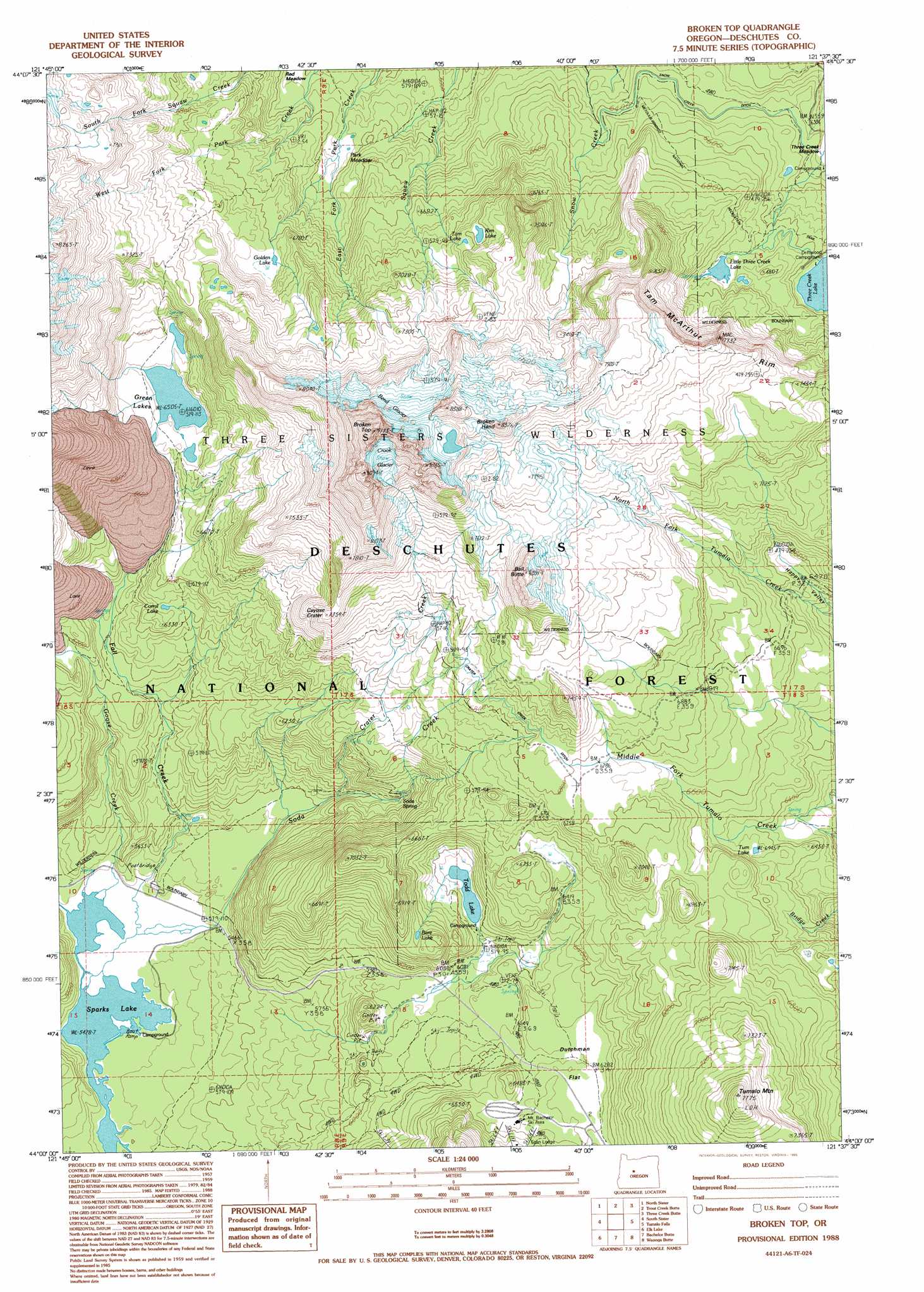
USGS Topo Quad 44121a6 - 1:24,000 scale
| Topo Map Name: | Lake Geneva |
| USGS Topo Quad ID: | 44121a6 |
| Print Size: | ca. 21 1/4" wide x 27" high |
| Southeast Coordinates: | 44° N latitude / 121.625° W longitude |
| Map Center Coordinates: | 44.0625° N latitude / 121.6875° W longitude |
| U.S. State: | OR |
| Filename: | o44121a6.jpg |
| Download Map JPG Image: | Lake Geneva topo map 1:24,000 scale |
| Map Type: | Topographic |
| Topo Series: | 7.5´ |
| Map Scale: | 1:24,000 |
| Source of Map Images: | United States Geological Survey (USGS) |
| Alternate Map Versions: |
Broken Top OR 1988, updated 1988 Download PDF Buy paper map Broken Top OR 1988, updated 1995 Download PDF Buy paper map Broken Top OR 1988, updated 1995 Download PDF Buy paper map Broken Top OR 2011 Download PDF Buy paper map Broken Top OR 2014 Download PDF Buy paper map |
| FStopo: | US Forest Service topo Broken Top is available: Download FStopo PDF Download FStopo TIF |
1:24,000 Topo Quads surrounding Lake Geneva
Clear Lake |
Mount Washington |
Black Crater |
Sisters |
Henkle Butte |
Linton Lake |
North Sister |
Trout Creek Butte |
Three Creek Butte |
Tumalo Dam |
Substitute Point |
South Sister |
Lake Geneva |
Tumalo Falls |
Shevlin Park |
Packsaddle Mountain |
Elk Lake |
Bachelor Butte |
Wanoga Butte |
Benham Falls |
Irish Mountain |
Crane Prairie Reservoir |
Round Mountain |
Pistol Butte |
Anns Butte |
> Back to 44121a1 at 1:100,000 scale
> Back to 44120a1 at 1:250,000 scale
> Back to U.S. Topo Maps home
Lake Geneva topo map: Gazetteer
Lake Geneva: Areas
Three Creek Meadow elevation 1926m 6318′Lake Geneva: Canals
Crater Creek Ditch elevation 2088m 6850′Lake Geneva: Cliffs
Tam McArthur Rim elevation 2216m 7270′Lake Geneva: Craters
Cayuse Crater elevation 2235m 7332′Lake Geneva: Dams
Little Three Creek Lake Dam elevation 2044m 6706′Lake Geneva: Flats
Dutchman Flat elevation 1915m 6282′Park Meadow elevation 1879m 6164′
Lake Geneva: Glaciers
Bend Glacier elevation 2384m 7821′Crook Glacier elevation 2574m 8444′
Lake Geneva: Lakes
Bare Lake elevation 1971m 6466′Corral Lake elevation 1913m 6276′
Golden Lake elevation 2021m 6630′
Green Lakes elevation 1984m 6509′
Little Three Creek Lake elevation 2044m 6706′
Rim Lake elevation 2133m 6998′
Sparks Lake elevation 1656m 5433′
Tam Lake elevation 2125m 6971′
Three Creek Lake elevation 1996m 6548′
Todd Lake elevation 1873m 6145′
Tum Lake elevation 1968m 6456′
Lake Geneva: Pillars
Broken Hand elevation 2533m 8310′Lake Geneva: Springs
Soda Spring elevation 1818m 5964′Lake Geneva: Streams
Crater Creek elevation 1731m 5679′Fall Creek elevation 1656m 5433′
Goose Creek elevation 1657m 5436′
Little Crater Creek elevation 1984m 6509′
Soda Creek elevation 1656m 5433′
Lake Geneva: Summits
Ball Butte elevation 2413m 7916′Broken Top elevation 2756m 9041′
Tumalo Mountain elevation 2370m 7775′
Lake Geneva: Trails
Broken Top Trail elevation 2056m 6745′Mud Lake Trail elevation 1689m 5541′
Three Creek Lake Trail elevation 2070m 6791′
Lake Geneva digital topo map on disk
Buy this Lake Geneva topo map showing relief, roads, GPS coordinates and other geographical features, as a high-resolution digital map file on DVD: