Three Creek Butte Topo Map Oregon
To zoom in, hover over the map of Three Creek Butte
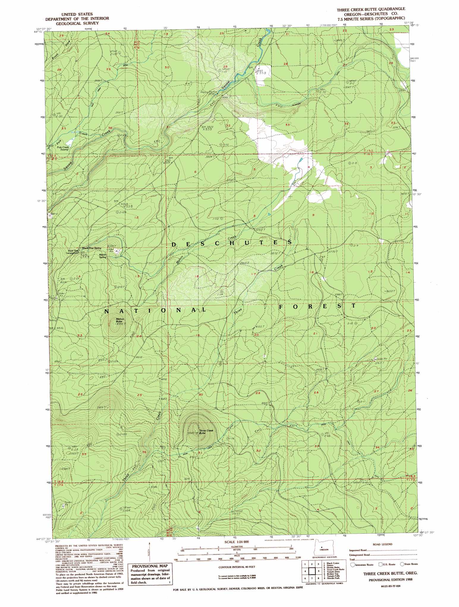
USGS Topo Quad 44121b5 - 1:24,000 scale
| Topo Map Name: | Three Creek Butte |
| USGS Topo Quad ID: | 44121b5 |
| Print Size: | ca. 21 1/4" wide x 27" high |
| Southeast Coordinates: | 44.125° N latitude / 121.5° W longitude |
| Map Center Coordinates: | 44.1875° N latitude / 121.5625° W longitude |
| U.S. State: | OR |
| Filename: | o44121b5.jpg |
| Download Map JPG Image: | Three Creek Butte topo map 1:24,000 scale |
| Map Type: | Topographic |
| Topo Series: | 7.5´ |
| Map Scale: | 1:24,000 |
| Source of Map Images: | United States Geological Survey (USGS) |
| Alternate Map Versions: |
Three Creek Butte OR 1988, updated 1988 Download PDF Buy paper map Three Creek Butte OR 2011 Download PDF Buy paper map Three Creek Butte OR 2014 Download PDF Buy paper map |
| FStopo: | US Forest Service topo Three Creek Butte is available: Download FStopo PDF Download FStopo TIF |
1:24,000 Topo Quads surrounding Three Creek Butte
Three Fingered Jack |
Black Butte |
Little Squaw Back |
Squaw Back Ridge |
Steelhead Falls |
Mount Washington |
Black Crater |
Sisters |
Henkle Butte |
Cline Falls |
North Sister |
Trout Creek Butte |
Three Creek Butte |
Tumalo Dam |
Tumalo |
South Sister |
Lake Geneva |
Tumalo Falls |
Shevlin Park |
Bend |
Elk Lake |
Bachelor Butte |
Wanoga Butte |
Benham Falls |
Lava Butte |
> Back to 44121a1 at 1:100,000 scale
> Back to 44120a1 at 1:250,000 scale
> Back to U.S. Topo Maps home
Three Creek Butte topo map: Gazetteer
Three Creek Butte: Canals
Maxwell Ditch elevation 1037m 3402′Pole Creek Ditch elevation 1188m 3897′
Three Creek Butte: Springs
Black Pine Spring elevation 1318m 4324′Melvin Spring elevation 1344m 4409′
Three Creek Butte: Streams
Lower Three Creek elevation 1475m 4839′Melvin Creek elevation 1130m 3707′
Three Creek elevation 1152m 3779′
Three Creek Butte: Summits
Melvin Butte elevation 1469m 4819′Three Creek Butte elevation 1673m 5488′
Three Creek Butte: Swamps
Pole Creek Swamp elevation 1231m 4038′Three Creek Butte digital topo map on disk
Buy this Three Creek Butte topo map showing relief, roads, GPS coordinates and other geographical features, as a high-resolution digital map file on DVD: