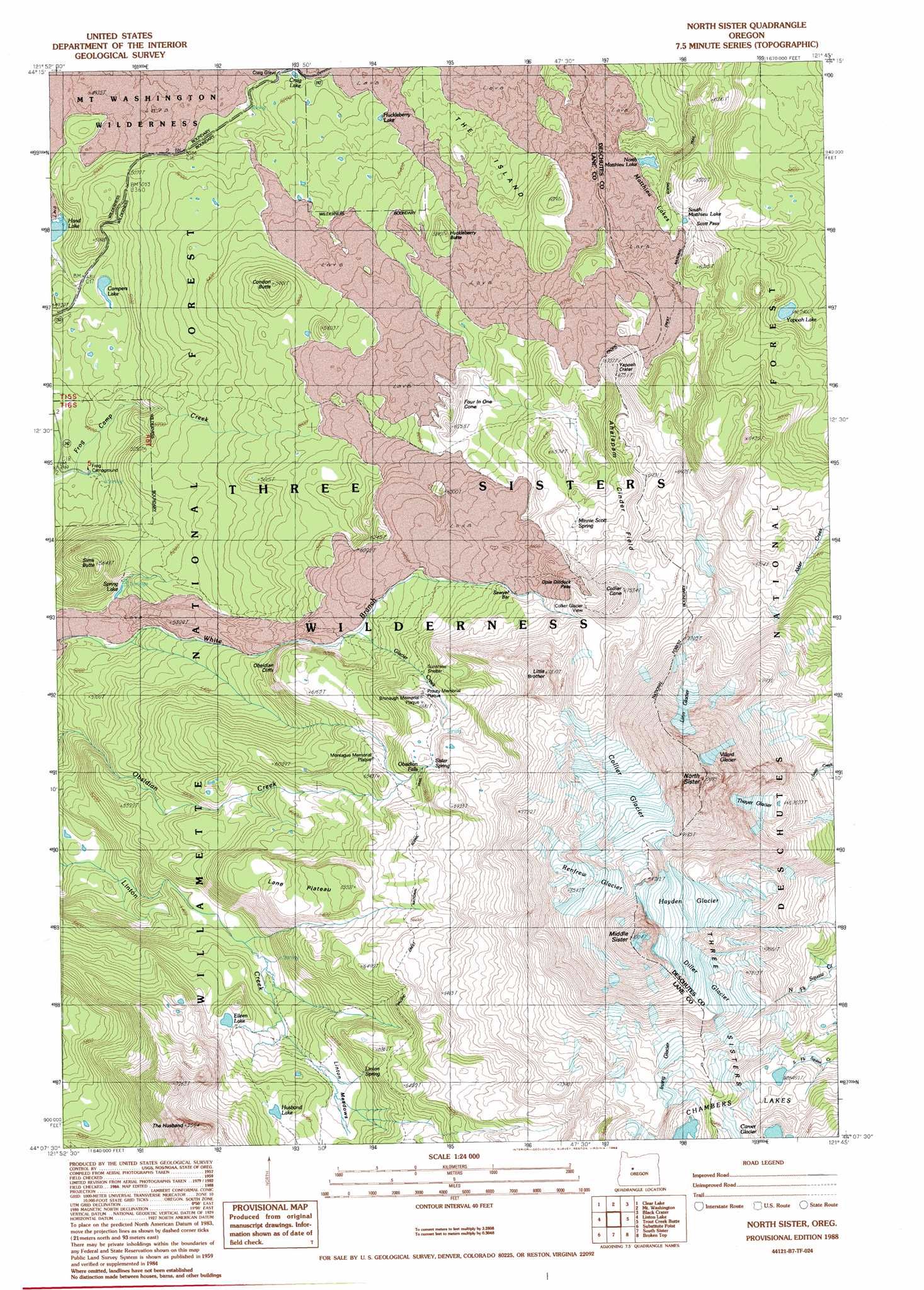
North Sister Topo Map Oregon
To zoom in, hover over the map of North Sister
USGS Topo Quad 44121b7 - 1:24,000 scale
| Topo Map Name: | North Sister |
| USGS Topo Quad ID: | 44121b7 |
| Print Size: | ca. 21 1/4" wide x 27" high |
| Southeast Coordinates: | 44.125° N latitude / 121.75° W longitude |
| Map Center Coordinates: | 44.1875° N latitude / 121.8125° W longitude |
| U.S. State: | OR |
| Filename: | o44121b7.jpg |
| Download Map JPG Image: | North Sister topo map 1:24,000 scale |
| Map Type: | Topographic |
| Topo Series: | 7.5´ |
| Map Scale: | 1:24,000 |
| Source of Map Images: | United States Geological Survey (USGS) |
| Alternate Map Versions: |
North Sister OR 1988, updated 1988 Download PDF Buy paper map North Sister OR 1988, updated 1988 Download PDF Buy paper map North Sister OR 1988, updated 1988 Download PDF Buy paper map North Sister OR 1997, updated 2001 Download PDF Buy paper map North Sister OR 2011 Download PDF Buy paper map North Sister OR 2014 Download PDF Buy paper map |
| FStopo: | US Forest Service topo North Sister is available: Download FStopo PDF Download FStopo TIF |
1:24,000 Topo Quads surrounding North Sister
Echo Mountain |
Santiam Junction |
Three Fingered Jack |
Black Butte |
Little Squaw Back |
Tamolitch Falls |
Clear Lake |
Mount Washington |
Black Crater |
Sisters |
Belknap Springs |
Linton Lake |
North Sister |
Trout Creek Butte |
Three Creek Butte |
French Mountain |
Substitute Point |
South Sister |
Lake Geneva |
Tumalo Falls |
Chucksney Mountain |
Packsaddle Mountain |
Elk Lake |
Bachelor Butte |
Wanoga Butte |
> Back to 44121a1 at 1:100,000 scale
> Back to 44120a1 at 1:250,000 scale
> Back to U.S. Topo Maps home
North Sister topo map: Gazetteer
North Sister: Bars
Sawyer Bar elevation 1991m 6532′North Sister: Cliffs
Obsidian Cliffs elevation 1855m 6085′North Sister: Craters
Harlow Crater elevation 1892m 6207′Yapoah Crater elevation 2047m 6715′
North Sister: Falls
Obsidian Falls elevation 2016m 6614′North Sister: Flats
Chief Joseph Island elevation 1892m 6207′Linton Meadows elevation 1823m 5980′
The Island elevation 1670m 5479′
North Sister: Gaps
Opie Dilldock Pass elevation 2112m 6929′Scott Pass elevation 1857m 6092′
North Sister: Glaciers
Collier Glacier elevation 2578m 8458′Diller Glacier elevation 2556m 8385′
Hayden Glacier elevation 2642m 8667′
Irving Glacier elevation 2330m 7644′
Linn Glacier elevation 2642m 8667′
Renfrew Glacier elevation 2603m 8540′
Thayer Glacier elevation 2339m 7673′
Villard Glacier elevation 2710m 8891′
North Sister: Lakes
Camp Lake elevation 2121m 6958′Campers Lake elevation 1475m 4839′
Chambers Lakes elevation 2202m 7224′
Craig Lake elevation 1574m 5164′
Eileen Lake elevation 1776m 5826′
Huckleberry Lake elevation 1608m 5275′
Husband Lake elevation 1850m 6069′
Matthieu Lakes elevation 1846m 6056′
North Matthieu Lake elevation 1768m 5800′
South Matthieu Lake elevation 1842m 6043′
Spring Lake elevation 1510m 4954′
Yapoah Lake elevation 1667m 5469′
North Sister: Lavas
Ahalapam Cinder Field elevation 2094m 6870′North Sister: Parks
Bronaugh Memorial Plaque elevation 2017m 6617′Montague Memorial Plaque elevation 1927m 6322′
Prouty Memorial Plaque elevation 1999m 6558′
North Sister: Plains
Frazier Upland elevation 2280m 7480′Lane Plateau elevation 1930m 6332′
North Sister: Springs
Linton Spring elevation 1870m 6135′Minnie Scott Spring elevation 2039m 6689′
Sister Spring elevation 2021m 6630′
North Sister: Streams
Glacier Creek elevation 1803m 5915′West Lava Creek elevation 1562m 5124′
North Sister: Summits
Collier Cone elevation 2276m 7467′Condon Butte elevation 1794m 5885′
Four in One Cone elevation 1893m 6210′
Huckleberry Butte elevation 1774m 5820′
Little Brother elevation 2335m 7660′
Middle Sister elevation 3051m 10009′
North Sister elevation 3039m 9970′
Sims Butte elevation 1675m 5495′
The Husband elevation 2244m 7362′
Three Sisters elevation 2345m 7693′
North Sister: Trails
Glacier Way elevation 1864m 6115′Millican Crater Trail elevation 1737m 5698′
Obsidian Trail elevation 1609m 5278′
Scott Trail elevation 1726m 5662′
North Sister digital topo map on disk
Buy this North Sister topo map showing relief, roads, GPS coordinates and other geographical features, as a high-resolution digital map file on DVD: