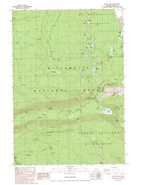
Linton Lake Topo Map Oregon
To zoom in, hover over the map of Linton Lake
USGS Topo Quad 44121b8 - 1:24,000 scale
| Topo Map Name: | Linton Lake |
| USGS Topo Quad ID: | 44121b8 |
| Print Size: | ca. 21 1/4" wide x 27" high |
| Southeast Coordinates: | 44.125° N latitude / 121.875° W longitude |
| Map Center Coordinates: | 44.1875° N latitude / 121.9375° W longitude |
| U.S. State: | OR |
| Filename: | o44121b8.jpg |
| Download Map JPG Image: | Linton Lake topo map 1:24,000 scale |
| Map Type: | Topographic |
| Topo Series: | 7.5´ |
| Map Scale: | 1:24,000 |
| Source of Map Images: | United States Geological Survey (USGS) |
| Alternate Map Versions: |
Linton Lake OR 1988, updated 1988 Download PDF Buy paper map Linton Lake OR 1997, updated 2001 Download PDF Buy paper map Linton Lake OR 2011 Download PDF Buy paper map Linton Lake OR 2014 Download PDF Buy paper map |
| FStopo: | US Forest Service topo Linton Lake is available: Download FStopo PDF Download FStopo TIF |
1:24,000 Topo Quads surrounding Linton Lake
> Back to 44121a1 at 1:100,000 scale
> Back to 44120a1 at 1:250,000 scale
> Back to U.S. Topo Maps home
Linton Lake topo map: Gazetteer
Linton Lake: Basins
Lake Valley elevation 1457m 4780′Linton Lake: Falls
Linton Falls elevation 1312m 4304′Proxy Falls elevation 960m 3149′
Linton Lake: Flats
Fingerboard Prairie elevation 1221m 4005′Spruce Meadow elevation 1394m 4573′
Linton Lake: Lakes
Benson Lake elevation 1583m 5193′Coffee Lake elevation 1524m 5000′
Elf Lake elevation 1608m 5275′
Glaze Lake elevation 1601m 5252′
Hand Lake elevation 1445m 4740′
Irish Camp Lake elevation 1422m 4665′
Island Lake elevation 1571m 5154′
Linton Lake elevation 1069m 3507′
Melakwa Lake elevation 1496m 4908′
Prince Lake elevation 1289m 4229′
Scott Lake elevation 1466m 4809′
Tenas Lakes elevation 1664m 5459′
Linton Lake: Springs
Alder Springs elevation 1135m 3723′Butler Spring elevation 1236m 4055′
Butte Spring elevation 1274m 4179′
Payne Spring elevation 792m 2598′
Linton Lake: Streams
Frog Camp Creek elevation 1254m 4114′Gold Creek elevation 1015m 3330′
Linton Creek elevation 1069m 3507′
Obsidian Creek elevation 1069m 3507′
Proxy Creek elevation 829m 2719′
Shadow Creek elevation 1299m 4261′
Linton Lake: Summits
Deer Butte elevation 1615m 5298′Proxy Point elevation 1891m 6204′
Scott Mountain elevation 1855m 6085′
The Knobs elevation 1316m 4317′
Two Butte elevation 1625m 5331′
Linton Lake: Trails
Benson Trail elevation 1533m 5029′Hand Lake Trail elevation 1565m 5134′
Linton Lake digital topo map on disk
Buy this Linton Lake topo map showing relief, roads, GPS coordinates and other geographical features, as a high-resolution digital map file on DVD:


