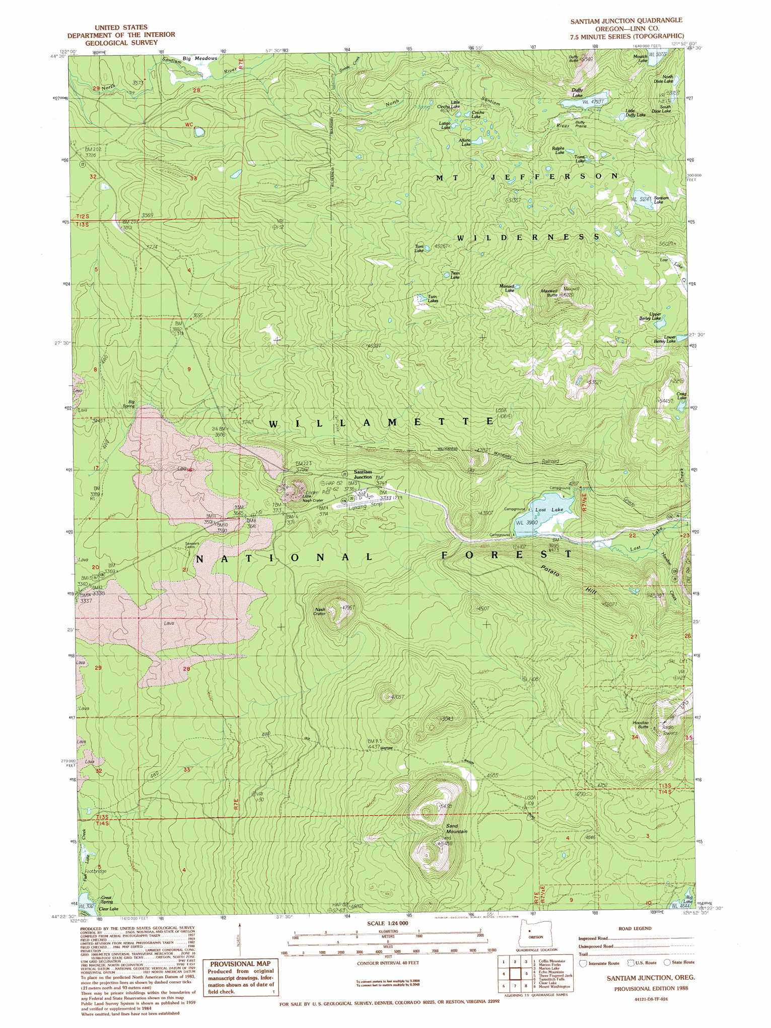
Santiam Junction Topo Map Oregon
To zoom in, hover over the map of Santiam Junction
USGS Topo Quad 44121d8 - 1:24,000 scale
| Topo Map Name: | Santiam Junction |
| USGS Topo Quad ID: | 44121d8 |
| Print Size: | ca. 21 1/4" wide x 27" high |
| Southeast Coordinates: | 44.375° N latitude / 121.875° W longitude |
| Map Center Coordinates: | 44.4375° N latitude / 121.9375° W longitude |
| U.S. State: | OR |
| Filename: | o44121d8.jpg |
| Download Map JPG Image: | Santiam Junction topo map 1:24,000 scale |
| Map Type: | Topographic |
| Topo Series: | 7.5´ |
| Map Scale: | 1:24,000 |
| Source of Map Images: | United States Geological Survey (USGS) |
| Alternate Map Versions: |
Santiam Junction OR 1988, updated 1988 Download PDF Buy paper map Santiam Junction OR 1988, updated 1988 Download PDF Buy paper map Santiam Junction OR 1997, updated 2001 Download PDF Buy paper map Santiam Junction OR 2011 Download PDF Buy paper map Santiam Junction OR 2014 Download PDF Buy paper map |
| FStopo: | US Forest Service topo Santiam Junction is available: Download FStopo PDF Download FStopo TIF |
1:24,000 Topo Quads surrounding Santiam Junction
Detroit |
Idanha |
Mount Bruno |
Mount Jefferson |
Lionshead |
Chimney Peak |
Coffin Mountain |
Marion Forks |
Marion Lake |
Candle Creek |
Harter Mountain |
Echo Mountain |
Santiam Junction |
Three Fingered Jack |
Black Butte |
Carpenter Mountain |
Tamolitch Falls |
Clear Lake |
Mount Washington |
Black Crater |
Mckenzie Bridge |
Belknap Springs |
Linton Lake |
North Sister |
Trout Creek Butte |
> Back to 44121a1 at 1:100,000 scale
> Back to 44120a1 at 1:250,000 scale
> Back to U.S. Topo Maps home
Santiam Junction topo map: Gazetteer
Santiam Junction: Airports
Santiam Junction State Airport elevation 1143m 3750′Santiam Junction: Craters
Little Nash Crater elevation 1203m 3946′Nash Crater elevation 1439m 4721′
Santiam Junction: Flats
Duffy Prairie elevation 1462m 4796′Santiam Junction: Lakes
Alforja Lake elevation 1421m 4662′Cincha Lake elevation 1387m 4550′
Craig Lake elevation 1619m 5311′
Duffy Lake elevation 1462m 4796′
Latigo Lake elevation 1396m 4580′
Little Cincha Lake elevation 1400m 4593′
Little Duffy Lake elevation 1474m 4835′
Lost Lake elevation 1220m 4002′
Lower Berley Lake elevation 1623m 5324′
Maxwell Lake elevation 1665m 5462′
North Dixie Lake elevation 1600m 5249′
Ralphs Lake elevation 1500m 4921′
Santiam Lake elevation 1579m 5180′
South Dixie Lake elevation 1618m 5308′
Toms Lake elevation 1514m 4967′
Toni Lake elevation 1466m 4809′
Train Lake elevation 1507m 4944′
Twin Lakes elevation 1479m 4852′
Upper Berley Lake elevation 1644m 5393′
Santiam Junction: Springs
Big Spring elevation 1046m 3431′Great Spring elevation 927m 3041′
Santiam Junction: Streams
Hoodoo Creek elevation 1239m 4064′Lost Lake Creek elevation 1550m 5085′
Swede Creek elevation 1166m 3825′
Santiam Junction: Summits
Duffy Butte elevation 1647m 5403′Hogg Rock elevation 1485m 4872′
Hoodoo Butte elevation 1709m 5606′
Maxwell Butte elevation 1831m 6007′
Potato Hill elevation 1579m 5180′
Sand Mountain elevation 1634m 5360′
Santiam Junction: Trails
Duffy Lake Trail elevation 1212m 3976′Lava Trail elevation 1515m 4970′
Maxwell Trail elevation 1410m 4625′
Santiam Junction digital topo map on disk
Buy this Santiam Junction topo map showing relief, roads, GPS coordinates and other geographical features, as a high-resolution digital map file on DVD: