Prairie Farm Spring Topo Map Oregon
To zoom in, hover over the map of Prairie Farm Spring
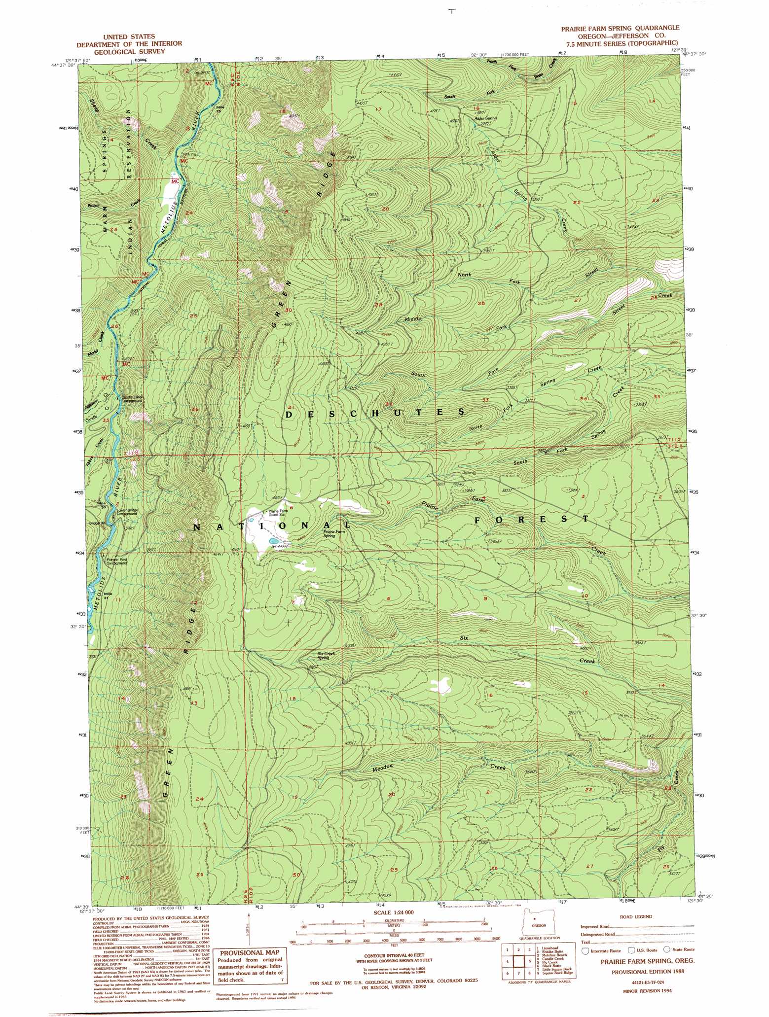
USGS Topo Quad 44121e5 - 1:24,000 scale
| Topo Map Name: | Prairie Farm Spring |
| USGS Topo Quad ID: | 44121e5 |
| Print Size: | ca. 21 1/4" wide x 27" high |
| Southeast Coordinates: | 44.5° N latitude / 121.5° W longitude |
| Map Center Coordinates: | 44.5625° N latitude / 121.5625° W longitude |
| U.S. State: | OR |
| Filename: | o44121e5.jpg |
| Download Map JPG Image: | Prairie Farm Spring topo map 1:24,000 scale |
| Map Type: | Topographic |
| Topo Series: | 7.5´ |
| Map Scale: | 1:24,000 |
| Source of Map Images: | United States Geological Survey (USGS) |
| Alternate Map Versions: |
Prairie Farm Spring OR 1988, updated 1988 Download PDF Buy paper map Prairie Farm Spring OR 1988, updated 1994 Download PDF Buy paper map Prairie Farm Spring OR 2011 Download PDF Buy paper map Prairie Farm Spring OR 2014 Download PDF Buy paper map |
| FStopo: | US Forest Service topo Prairie Farm Spring is available: Download FStopo PDF Download FStopo TIF |
1:24,000 Topo Quads surrounding Prairie Farm Spring
Olallie Butte |
Boulder Lake |
Sawmill Butte |
Potters Ponds |
Warm Springs |
Mount Jefferson |
Lionshead |
Shitike Butte |
Metolius Bench |
Seekseequa Junction |
Marion Lake |
Candle Creek |
Prairie Farm Spring |
Fly Creek |
Round Butte Dam |
Three Fingered Jack |
Black Butte |
Little Squaw Back |
Squaw Back Ridge |
Steelhead Falls |
Mount Washington |
Black Crater |
Sisters |
Henkle Butte |
Cline Falls |
> Back to 44121e1 at 1:100,000 scale
> Back to 44120a1 at 1:250,000 scale
> Back to U.S. Topo Maps home
Prairie Farm Spring topo map: Gazetteer
Prairie Farm Spring: Bridges
Bridge 99 elevation 831m 2726′Prairie Farm Spring: Ridges
Green Ridge elevation 1468m 4816′Prairie Farm Spring: Springs
Alder Spring elevation 1216m 3989′Prairie Farm Spring elevation 1312m 4304′
Six Creek Spring elevation 1307m 4288′
Prairie Farm Spring: Streams
Abbot Creek elevation 834m 2736′Alder Spring Creek elevation 863m 2831′
Candle Creek elevation 818m 2683′
Jefferson Creek elevation 818m 2683′
Mariel Creek elevation 829m 2719′
Meadow Creek elevation 912m 2992′
Middle Fork Street Creek elevation 882m 2893′
North Fork Bean Creek elevation 1078m 3536′
North Fork Spring Creek elevation 888m 2913′
North Fork Street Creek elevation 802m 2631′
Sheep Creek elevation 781m 2562′
South Fork Bean Creek elevation 1078m 3536′
South Fork Spring Creek elevation 888m 2913′
South Fork Street Creek elevation 882m 2893′
Walker Creek elevation 784m 2572′
Prairie Farm Spring: Trails
Reservation Trail elevation 979m 3211′Prairie Farm Spring digital topo map on disk
Buy this Prairie Farm Spring topo map showing relief, roads, GPS coordinates and other geographical features, as a high-resolution digital map file on DVD: