Pinhead Buttes Topo Map Oregon
To zoom in, hover over the map of Pinhead Buttes
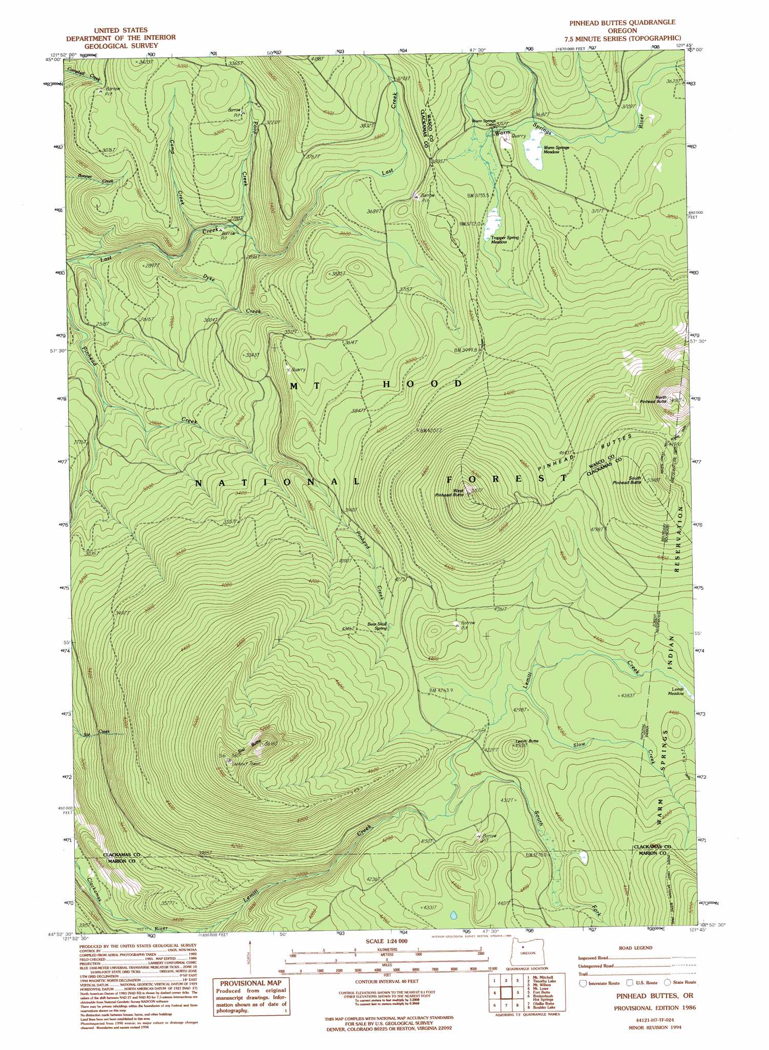
USGS Topo Quad 44121h7 - 1:24,000 scale
| Topo Map Name: | Pinhead Buttes |
| USGS Topo Quad ID: | 44121h7 |
| Print Size: | ca. 21 1/4" wide x 27" high |
| Southeast Coordinates: | 44.875° N latitude / 121.75° W longitude |
| Map Center Coordinates: | 44.9375° N latitude / 121.8125° W longitude |
| U.S. State: | OR |
| Filename: | o44121h7.jpg |
| Download Map JPG Image: | Pinhead Buttes topo map 1:24,000 scale |
| Map Type: | Topographic |
| Topo Series: | 7.5´ |
| Map Scale: | 1:24,000 |
| Source of Map Images: | United States Geological Survey (USGS) |
| Alternate Map Versions: |
Pinhead Buttes OR 1986, updated 1988 Download PDF Buy paper map Pinhead Buttes OR 1986, updated 1994 Download PDF Buy paper map Pinhead Buttes OR 1986, updated 1994 Download PDF Buy paper map Pinhead Buttes OR 1997, updated 1999 Download PDF Buy paper map Pinhead Buttes OR 2011 Download PDF Buy paper map Pinhead Buttes OR 2014 Download PDF Buy paper map |
| FStopo: | US Forest Service topo Pinhead Buttes is available: Download FStopo PDF Download FStopo TIF |
1:24,000 Topo Quads surrounding Pinhead Buttes
Three Lynx |
High Rock |
Wolf Peak |
Wapinitia Pass |
Post Point |
Fish Creek Mountain |
Mount Mitchell |
Timothy Lake |
Mount Wilson |
Beaver Butte |
Bull Of The Woods |
Mount Lowe |
Pinhead Buttes |
Fort Butte |
Sidwalter Buttes |
Mother Lode Mountain |
Breitenbush Hot Spring |
Olallie Butte |
Boulder Lake |
Sawmill Butte |
Idanha |
Mount Bruno |
Mount Jefferson |
Lionshead |
Shitike Butte |
> Back to 44121e1 at 1:100,000 scale
> Back to 44120a1 at 1:250,000 scale
> Back to U.S. Topo Maps home
Pinhead Buttes topo map: Gazetteer
Pinhead Buttes: Flats
Lemiti Meadow elevation 1325m 4347′Trapper Spring Meadow elevation 1152m 3779′
Pinhead Buttes: Springs
Bear Skull Spring elevation 1300m 4265′Pinhead Buttes: Streams
Camp Creek elevation 837m 2746′Dyke Creek elevation 791m 2595′
Fall Creek elevation 740m 2427′
Poop Creek elevation 847m 2778′
Slow Creek elevation 1296m 4251′
South Fork Lemiti Creek elevation 1250m 4101′
Pinhead Buttes: Summits
Lemiti Butte elevation 1379m 4524′North Pinhead Butte elevation 1641m 5383′
Pinhead Buttes elevation 1432m 4698′
Red Box elevation 1221m 4005′
Sisi Butte elevation 1689m 5541′
South Pinhead Butte elevation 1628m 5341′
West Pinhead Butte elevation 1688m 5538′
Pinhead Buttes: Swamps
Warm Springs Meadow elevation 1130m 3707′Pinhead Buttes: Trails
Boundary Trail elevation 1308m 4291′Fire Springs Trail elevation 1133m 3717′
Pinhead Buttes digital topo map on disk
Buy this Pinhead Buttes topo map showing relief, roads, GPS coordinates and other geographical features, as a high-resolution digital map file on DVD: