Harvey Mountain Topo Map Oregon
To zoom in, hover over the map of Harvey Mountain
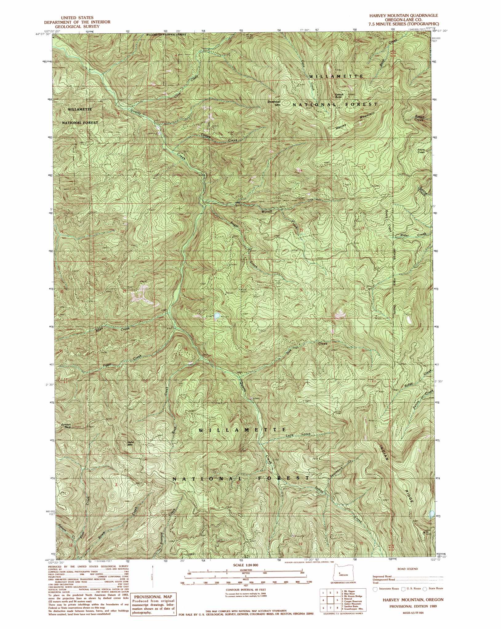
USGS Topo Quad 44122a3 - 1:24,000 scale
| Topo Map Name: | Harvey Mountain |
| USGS Topo Quad ID: | 44122a3 |
| Print Size: | ca. 21 1/4" wide x 27" high |
| Southeast Coordinates: | 44° N latitude / 122.25° W longitude |
| Map Center Coordinates: | 44.0625° N latitude / 122.3125° W longitude |
| U.S. State: | OR |
| Filename: | o44122a3.jpg |
| Download Map JPG Image: | Harvey Mountain topo map 1:24,000 scale |
| Map Type: | Topographic |
| Topo Series: | 7.5´ |
| Map Scale: | 1:24,000 |
| Source of Map Images: | United States Geological Survey (USGS) |
| Alternate Map Versions: |
Harvey Mountain OR 1989, updated 1989 Download PDF Buy paper map Harvey Mountain OR 1989, updated 1989 Download PDF Buy paper map Harvey Mountain OR 1997, updated 2001 Download PDF Buy paper map Harvey Mountain OR 2011 Download PDF Buy paper map Harvey Mountain OR 2014 Download PDF Buy paper map |
| FStopo: | US Forest Service topo Harvey Mountain is available: Download FStopo PDF Download FStopo TIF |
1:24,000 Topo Quads surrounding Harvey Mountain
Farmers Butte |
Swamp Mountain |
Tidbits Mountain |
Carpenter Mountain |
Tamolitch Falls |
Vida |
Mount Hagan |
Blue River |
Mckenzie Bridge |
Belknap Springs |
Goat Mountain |
Nimrod |
Harvey Mountain |
Cougar Reservoir |
French Mountain |
Saddleblanket Mountain |
Sinker Mountain |
Sardine Butte |
Grasshopper Mountain |
Chucksney Mountain |
Westfir West |
Westfir East |
Huckleberry Mountain |
Blair Lake |
Waldo Mountain |
> Back to 44122a1 at 1:100,000 scale
> Back to 44122a1 at 1:250,000 scale
> Back to U.S. Topo Maps home
Harvey Mountain topo map: Gazetteer
Harvey Mountain: Pillars
Symbol Rock elevation 1089m 3572′Harvey Mountain: Ridges
Indian Ridge elevation 1593m 5226′Harvey Mountain: Streams
Allen Creek elevation 510m 1673′Briem Creek elevation 570m 1870′
Buck Creek elevation 548m 1797′
Cane Creek elevation 349m 1145′
Coffee Creek elevation 400m 1312′
Doe Creek elevation 574m 1883′
Fawn Creek elevation 507m 1663′
Indian Creek elevation 736m 2414′
Lytle Creek elevation 676m 2217′
Rosey Creek elevation 856m 2808′
Saturn Creek elevation 586m 1922′
Sugar Creek elevation 464m 1522′
Switch Back Creek elevation 868m 2847′
Wycoff Creek elevation 475m 1558′
Harvey Mountain: Summits
Deathball Mountain elevation 1399m 4589′Harvey Mountain elevation 1475m 4839′
Hehe Mountain elevation 1208m 3963′
Katsuk Butte elevation 1452m 4763′
Harvey Mountain: Trails
Fall Creek Trail (historical) elevation 806m 2644′Pernot Trail (historical) elevation 1145m 3756′
Harvey Mountain digital topo map on disk
Buy this Harvey Mountain topo map showing relief, roads, GPS coordinates and other geographical features, as a high-resolution digital map file on DVD: