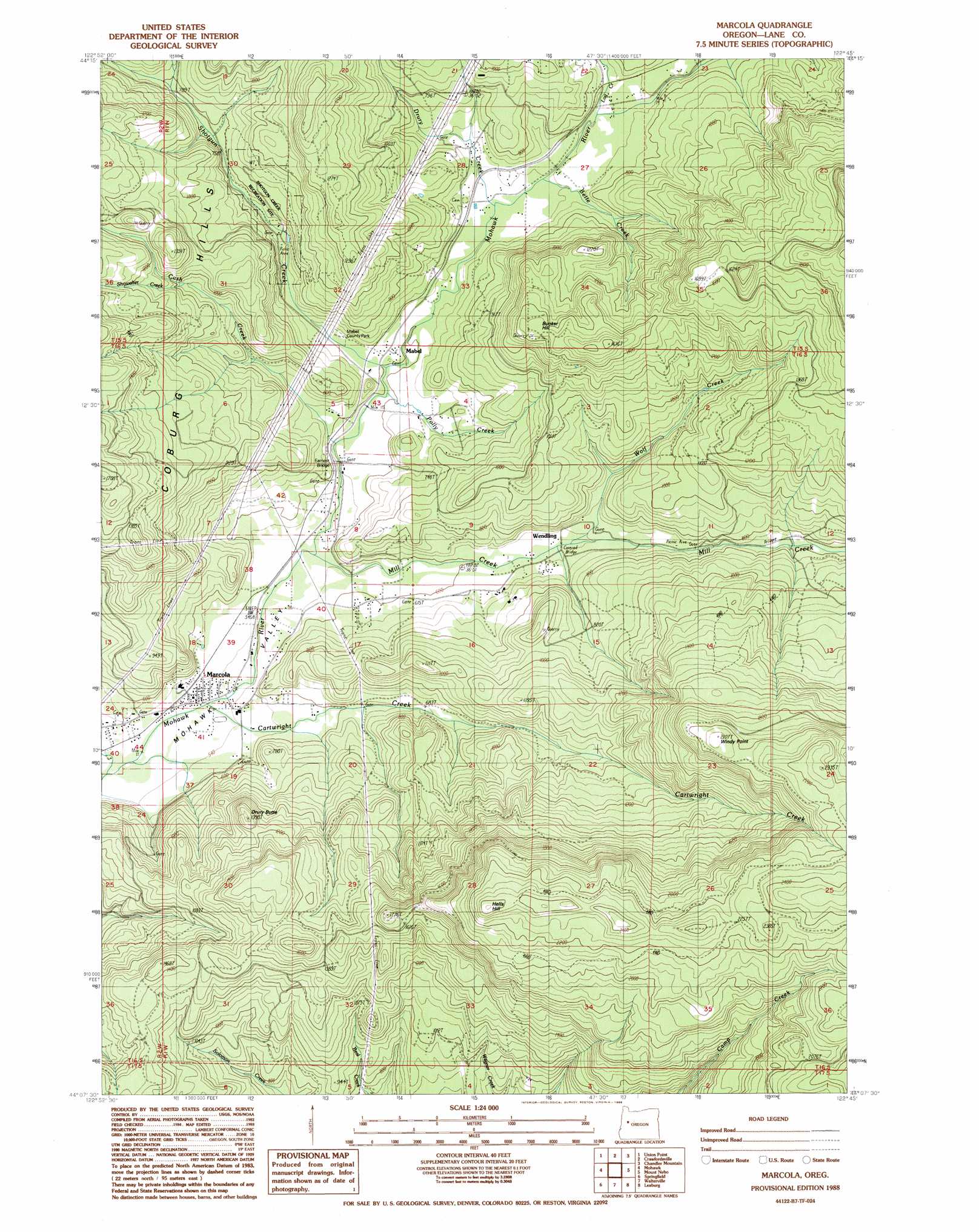
Marcola Topo Map Oregon
To zoom in, hover over the map of Marcola
USGS Topo Quad 44122b7 - 1:24,000 scale
| Topo Map Name: | Marcola |
| USGS Topo Quad ID: | 44122b7 |
| Print Size: | ca. 21 1/4" wide x 27" high |
| Southeast Coordinates: | 44.125° N latitude / 122.75° W longitude |
| Map Center Coordinates: | 44.1875° N latitude / 122.8125° W longitude |
| U.S. State: | OR |
| Filename: | o44122b7.jpg |
| Download Map JPG Image: | Marcola topo map 1:24,000 scale |
| Map Type: | Topographic |
| Topo Series: | 7.5´ |
| Map Scale: | 1:24,000 |
| Source of Map Images: | United States Geological Survey (USGS) |
| Alternate Map Versions: |
Marcola OR 1988, updated 1988 Download PDF Buy paper map Marcola OR 2011 Download PDF Buy paper map Marcola OR 2014 Download PDF Buy paper map |
1:24,000 Topo Quads surrounding Marcola
Halsey |
Brownsville |
Waterloo |
Sweet Home |
Green Peter |
Indian Head |
Union Point |
Crawfordsville |
Chandler Mountain |
Farmers Butte |
Coburg |
Mohawk |
Marcola |
Mount Nebo |
Vida |
Eugene East |
Springfield |
Walterville |
Leaburg |
Goat Mountain |
Creswell |
Jasper |
Lowell |
Fall Creek Lake |
Saddleblanket Mountain |
> Back to 44122a1 at 1:100,000 scale
> Back to 44122a1 at 1:250,000 scale
> Back to U.S. Topo Maps home
Marcola topo map: Gazetteer
Marcola: Bridges
Earnest Bridge elevation 171m 561′Marcola: Parks
Mabel Park elevation 194m 636′Shotgun Recreational Site elevation 248m 813′
Marcola: Populated Places
Mabel elevation 186m 610′Marcola elevation 162m 531′
Wendling elevation 195m 639′
Marcola: Post Offices
Mabel Post Office (historical) elevation 186m 610′Marcola Post Office elevation 162m 531′
Wendling Post Office (historical) elevation 195m 639′
Marcola: Reservoirs
Bedortha Reservoir elevation 253m 830′Marcola: Streams
Beaver Creek elevation 194m 636′Bette Creek elevation 213m 698′
Carolyn Creek elevation 235m 770′
Cartwright Creek elevation 164m 538′
Cash Creek elevation 172m 564′
Crooked Creek elevation 257m 843′
Dorothy Creek elevation 211m 692′
Drury Creek elevation 198m 649′
Ethel Creek elevation 226m 741′
Log Creek elevation 211m 692′
Mill Creek elevation 169m 554′
Parsons Creek elevation 161m 528′
Polly Creek elevation 183m 600′
Rock Creek elevation 189m 620′
Seeley Creek elevation 297m 974′
Shotgun Creek elevation 183m 600′
Showalter Creek elevation 279m 915′
Wolf Creek elevation 195m 639′
Marcola: Summits
Bunker Hill elevation 444m 1456′Drury Butte elevation 397m 1302′
Hells Hill elevation 746m 2447′
Windy Point elevation 639m 2096′
Marcola digital topo map on disk
Buy this Marcola topo map showing relief, roads, GPS coordinates and other geographical features, as a high-resolution digital map file on DVD: